![]()
Diferencia entre revisiones de «ENG:Piedra Numerada»
(Página creada con «{{Google Translate}} ES:Piedra Numerada {{Indexada}} category:KMZconTrack {{RutaForme |Actividad=Trekking, Randonnée |País=Chile |CiudadesChile=Santiago |VallesSt...») |
|||
| Línea 1: | Línea 1: | ||
| − | |||
[[ES:Piedra Numerada]] | [[ES:Piedra Numerada]] | ||
{{Indexada}} | {{Indexada}} | ||
| Línea 14: | Línea 13: | ||
|Señalizacion=Inexistente | |Señalizacion=Inexistente | ||
|Infraestructura=Inexistente | |Infraestructura=Inexistente | ||
| − | + | |ComparteIdayRetorno=Ida y Retorno por la misma ruta | |
| − | |ComparteIdayRetorno= | + | |
|Distancia=26116 | |Distancia=26116 | ||
|MetrosAscenso=1107 | |MetrosAscenso=1107 | ||
| Línea 27: | Línea 25: | ||
|Primer Autor=[[Usuario:Joaquin.baranao|Joaquín Barañao]] | |Primer Autor=[[Usuario:Joaquin.baranao|Joaquín Barañao]] | ||
|Imágen Principal=Piedra Numerada (6).jpg | |Imágen Principal=Piedra Numerada (6).jpg | ||
| − | |ComentariosImagen= | + | |ComentariosImagen=Cepo valley, looking towards Piedra Numerada, 9/9/07 |
|m=https://www.google.com/maps/d/u/0/embed?mid=1U0Wd4_CWFqUPKjdcMGosvk2SlTnuCGe2 | |m=https://www.google.com/maps/d/u/0/embed?mid=1U0Wd4_CWFqUPKjdcMGosvk2SlTnuCGe2 | ||
| − | |KMLZ= | + | |KMLZ=Macizo Plomo.kmz |
|ComentariosMapa= | |ComentariosMapa= | ||
| − | {{colores|red| | + | {{colores|red|Trek to the base camp}} |
| − | {{colores|blue| | + | {{colores|blue|Other routes in the area: [[Travesía_Federación_-_Cancha_de_Carreras|Federación - Cancha Carrera]]}} |
| − | + | {{colores|yellow|Ascents in the area: [[Cerro_El_Plomo|El Plomo]], [[Cerro_Leonera|Leonera]], [[Cerro_Pintor|Pintor]], [[Cerro_La_Parva|Parva]]}} | |
| − | {{colores|yellow| | + | {{colores|green|Roads}} |
| − | {{colores|green| | + | {{colores|black|Ski lifts}} |
| − | {{colores|black| | + | |
|TipoDeMap=hybrid | |TipoDeMap=hybrid | ||
}} | }} | ||
| − | |||
| − | == | + | ==Season == |
| − | + | [[File:Climograma_farellones.png|thumb|Climograph of Farellones, village close to El Plomo]] | |
| − | + | [[File:Pistas Valle Nevado2.jpg|thumb|Map of Valle Nevado ski pistes. The red circle marks the exit where the treks [[Piedra Numerada]] and El Plomo Base camp start.]] | |
| − | + | [[File:Perfil_de_ascenso_Cerro_El_Plomo_desde_Valle_Nevado.PNG|thumb|Perfil de ascenso Cerro El Plomo desde el máximo vehicular de Valle Nevado]] | |
| − | [[File: | + | [[File:Piedra Numerada (5).jpg|thumb|Starting the descent from the dam. 9/9/07]] |
| − | + | [[File:Piedra Numerada (2).jpg|thumb|View after the valley, 9/9/07]] | |
| − | + | [[File:Piedra Numerada2.jpg|thumb|Piedra Numerada from the first viewpoint. Point 2 on the map]] | |
| − | [[File:Piedra Numerada ( | + | [[File:Piedra Numerada (7).jpg|thumb|Piedra Numerada. 9/9/07]] |
| − | [[File: | + | [[Archivo:Piedra_Numerada_por_Carlos_Hevia_Patagon_Journal.jpg|thumb|Piedra Numerada, por Carlos Hevia, Patagon Journal]] |
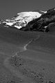
| − | + | [[File:Piedra Numerada (9).jpg|thumb|Valle del Cepo desde Piedra Numerada. 9 de septiembre de 2007]] | |
| − | + | *'''Mountaineering''': Between November and April. Summer weekends can get crowded, so if you’re looking for a wild high mountain experience, either choose a different destination or visit on a weekday. | |
| − | + | *'''Ski Touring''': From June to generally the first half of October. | |
| − | + | ||
| − | + | ||
| − | + | ||
| − | + | {{Access to Valle Nevado Dam}} | |
| − | + | ==Route description== | |
| − | {{ | + | |
| − | ==== | + | |
| − | + | ||
| − | + | ||
| − | + | ||
| − | + | ||
| − | + | === Valle Nevado Hotel - Dam (if it can't be driven)=== | |
| − | + | ====Summer==== | |
| − | + | ||
| − | + | ||
| − | + | The first part of hiking route is different than the motorable road, because it avoids the ascent to Cerro Mirador, and hence is described below. | |
| − | + | ||
| − | + | ||
| − | + | ||
| − | + | ||
| − | + | ||
| − | + | ||
| − | + | ||
| − | + | ||
| − | + | ||
| − | + | ||
| − | + | ||
| − | + | ||
| − | + | ||
| − | + | ||
| − | + | ||
| − | + | ||
| − | + | ||
| − | + | ||
| − | + | ||
| − | + | ||
| − | + | ||
| + | By foot, instead of taking the road at the left of the slope, advance along the road that ascends straight facing the slope, keeping the wooden fences at your immediate left. At 3150m there will be a bifurcation: take the right. It will go down a few meters. The road starts to progressively bend to the east, in an area almost flat. You will reach a small dam (different to the two described in the access section). Circle the dam along its right, and then carry on to the north. From then onwards, you will walk along a pedestrian trail, which resulted from the construction of a pipe. Following this trail you will Las Ballicas station. From there, follow the same road described above, all the way to the dam on top. Only at the beginning take the shortcut straight along the bottom of the valley instead of walking the ample curve of the motorable road. | ||
| + | ====Winter==== | ||
| + | Take the lift ''El Mirador''. It will get you to the ridge that links to the valley located to the east. Ski down the gentle ‘’El Trote’’ along the slope till the base of the lift ''Tres Puntas''. This second lift will get you to 3667m. Ski down ‘’Vals’’ and in the vicinity of the dam take your right to start your way outbound. | ||
| + | {{Dam - Piedra Numerada}} | ||
| − | == Weather | + | ==Weather forecast== |
{{AccuWeatherValleMapocho}} | {{AccuWeatherValleMapocho}} | ||
| + | {{Permits Fees Valle Nevado}} | ||
| − | {{Trekkings Chile}} | + | {{Horses Farellones}} |
| + | ==Photo gallery== | ||
| + | <gallery> | ||
| + | File:Cerro_el_plomo_.JPG|Trail, by '''[http://www.joseguridi.cl/ José Guridi]''' | ||
| + | El_Plomo_y_Altar_Santiago.JPG|Cerro El Plomo and [[Cerro Altar]] from Santiago. | ||
| + | File:Piuquencillo_de_cumbre.jpg|Cerro El Plomo, [[Nevado Juncal]] and [[Nevado El Plomo]] from the summit of [[Piuquencillo]]. Looking north, august 2002 | ||
| + | File:Piuquencillo1.jpg|[[Cerro El Plomo]] and [[Leonera]] from [[Piuquencillo]]. August 2002 | ||
| + | </gallery> | ||
| + | {{Trekkings Chile english}} | ||
Revisión del 15:54 3 ene 2019

| |


|
|
|
| |||||||||||||||||||||||||||||||||||||||||||||||||||||||||||||||||||||||
.jpg)


Season


.jpg)
.jpg)

.jpg)

.jpg)
- Mountaineering: Between November and April. Summer weekends can get crowded, so if you’re looking for a wild high mountain experience, either choose a different destination or visit on a weekday.
- Ski Touring: From June to generally the first half of October.
Access
The first section of this route can be made from Valle Nevado or from La Parva. It is described from Valle Nevado because it is much shorter if the dam can be reachead by car (from December to May). To start from La Parva, se the respective explanation.
By car
From Santiago, take the paved road G-21 towards the ski centers and “Los Bronces” mine. Distance is 15,8 km towards the fork that leads to the mine, measured from Terpel gas station which is located at the end of Las Condes Av (meeting ground for skiers, cyclists, and mountaineers that venture into the valley). Take a right at the fork and continue on a very narrow paved road that abruptly ascends on closed curves. Road protection is poor and you should drive with caution especially during the winter months. An additional 16km on this mountain road will take you to the town of Farellones, on curve 40, 32km from Santiago. From Farellones, it is 13km more on a road that ascends many more curves up to the 3025 AMSL of Valle Nevado hotel, where there is a spacious parking lot.
From Valle Nevado to the dam by car
If a 4x4 vehicle is available, a permit to drive along the ski area can be asked for. Beyond the barrier, at the beginning of the ski slopes, a dirt road starts climbing right in front of the hotel. After a curve it goes along the left slope of the hill. There will be a road that goes down to the left and another one that goes up to the right, but you must keep driving on the one you have been following until reaching the upper part of the ridge that extends to the hotel. This point is also distinguishable by the end of El Mirador lift. From here head down eastward till you reach a small dam, by Las Ballicas station. Once there, start climbing again along the long road that ascends northward until the second dam. Park a couple of meters beyond the dam, the road to the north ends.
By public transportation
During the ski season (mid June to the end of September), the following companies make the trip:
- SNOWTOURS
- Address: Huerfanos 502, next to Santa Lucia hill, Bellas Artes neighbourhood, near Santa Lucia (red line 1) and Bellas Artes (green line 5) metro stations
- Phone: (2) 2982 8200 - (2) 3216 1106 - Whatsapp: +569 7997 3170
- reservas@snowtours.cl
- Departures from: Airport, Downtown Santiago (on Huerfanos and Santa Lucia), hotels and other spots.
- They also do trips from the airport to downtown, vineyard tours, Valparaiso and Vina del Mar, Isla Negra and other spots.
They are the cheapest and leave the earliest. It is very easy to get to them and their meeting spots
- KL Adventure
- Address: Santa Isabel Supermarket Cantagallo, Las Condes, Santiago
- Fono: (2) 217 91 01
- Departures from: Airport, Santa Isabel Supermarket Cantagallo, Ski Rental.
They are located almost at the entrance of the road to the ski centers, service is only from the hotel.
- Ski Total
- Address: Avda. Apoquindo 4900 Local 37-46 (Omnium building), Santiago
- Phone: (2) 246 68 81
- Departures from: Omnium building, Santa Isabel Supermarket Cantagallo, Los Trapenses mall.
Route description
Valle Nevado Hotel - Dam (if it can't be driven)
Summer
The first part of hiking route is different than the motorable road, because it avoids the ascent to Cerro Mirador, and hence is described below.
By foot, instead of taking the road at the left of the slope, advance along the road that ascends straight facing the slope, keeping the wooden fences at your immediate left. At 3150m there will be a bifurcation: take the right. It will go down a few meters. The road starts to progressively bend to the east, in an area almost flat. You will reach a small dam (different to the two described in the access section). Circle the dam along its right, and then carry on to the north. From then onwards, you will walk along a pedestrian trail, which resulted from the construction of a pipe. Following this trail you will Las Ballicas station. From there, follow the same road described above, all the way to the dam on top. Only at the beginning take the shortcut straight along the bottom of the valley instead of walking the ample curve of the motorable road.
Winter
Take the lift El Mirador. It will get you to the ridge that links to the valley located to the east. Ski down the gentle ‘’El Trote’’ along the slope till the base of the lift Tres Puntas. This second lift will get you to 3667m. Ski down ‘’Vals’’ and in the vicinity of the dam take your right to start your way outbound.
Dam - Piedra Numerada
Meeting Point for Valle Nevado and La Parva paths
Altitude: 3.550 AMSL | Km:0
Upon reaching this area of the dam, you must continue on the path that descends the hillside in direction to the northeast, or in other words, to the creek and green valley.
Creek (Point 2)
Altitude: 3.425 AMSL | Km:1
You will reach a small creek of crystal clear water (ok to drink), which is a good spot to fill up. After crossing the creek, the path begins to ascend. You must skip through rocks which during the winter will creep from under the snow. After 1,1km and a 90m altitude difference, you will reach the highest part of the hill: a nice overlook of the Cepo valley. First Lookout Point (Point 3) Altitude: 3.512 AMSL | Km:2,1 From this point you can clearly see the Cepo river valley and the impressive glaciers of “El Plomo” on the background. The vegetated plateau on the Cepo river bed up the valley, belongs to “Piedra Numerada”, a very good spot for camping. Immediately after this flat, you will see rocky walls that mark its abrupt south border. You must continue on the path that now has a north direction and softly descends.
Detour to “Piedra Numerada” (Point 4)
Altitude: 3.407 AMSL | Km:3,8
You have arrived to the wetlands of “Piedra Numerada”, a peaceful valley with plenty of water and vegetation. If you would like to go to the camping area you must abandon the path and walk towards the center of the wetland, where you will find good camping spots.
Weather forecast
Permits | Fees
Fortunately, still no permit or fee is required to know the area or climb its summits. However, Valle Nevado demands to inform in advance of the visit, in order to keep a log:
- E-mail: lsepulveda@vallenevado.com
- Phone: +56224777000
- Free.
Through La Parva, on the contrary, there is no control whatsoever.
Hire mules and/or horses

- Luis Polanco Leal: 02-28236973 - +56990873117. Los Refugios 16573, Lo Barnechea
- Javier Morales: +56992918057
- Marco Berrioz: +56993478505
- Luis Patricio Quiroz Robles, alias "Pato-Lucho": 3215886, +56997790735 y +56992660628
- Javier Pinto: +56990973965
Prices are in the area of CLP$25000 (US$ 27.2 as of June 2024) per animal per day. On top of that, add the value of the arriero (owner).
Photo gallery
Trail, by José Guridi
Cerro El Plomo and Cerro Altar from Santiago.
Cerro El Plomo, Nevado Juncal and Nevado El Plomo from the summit of Piuquencillo. Looking north, august 2002
Cerro El Plomo and Leonera from Piuquencillo. August 2002

