![]()
ENG:Refugio Plantat

| |


|
|
| |||||||||||||||||||||||||||||||||||||||||||||||||


Season


- Trekking: From late October, when there is still some snow left, till the beginning of May. Ideal in November and December
- Randonee: Between mid June to August. Unless it has snowed recently, it’s very likely that skies will have to be carried the first half an hour or so.
Access
By car
From the intersection at las Vizcachas (Avenida Camilo Enríquez and Avenida Eyzaguirre, km 0), take the road G-25 towards Cajón del Maipo, and follow it until km 65.1 (asphalt ends in the km 66.3 just before Lo Valdés) where there is a bifurcation. To the left, it leads to Baños Morales along a dirt road, located on the other side of the El Volcán river. Between June and September this road might be closed if there have been recent snowstorms. You can check the road status with Carabineros at San Gabriel (+56228611008 y +56228612290) although their answers tend to be on the conservative side.. This will be the last place to resupply. Continue along the main road, without taking the detour to Baños Morales. 1.5 kms beyond that fork the mining settlement of Lo Valdés is reached. 6 kms ahead, having past a steep ascent with pavement in very poor condition (“Cuesta de los Afligidos”, or ascent of the afflicted), there is a bridge that crosses the river Colina. Just 120 meters after the bridge you will be in El Cabrerío ("the goat place"), distinguishable by a big boulder with a chimney on top. It’s the place to park
Public transport and hitchhiking
Public busses to Cajón del Maipo
- Public busses (subsidized): El Alfalfal – San José de Maipo; Baños Morales (Lo Valdés) – El Volcán – San José de Maipo and El Volcán–San José de Maipo cost CLP$1200 (US$ 1.2 as of April 2024). It can cost as little as $300 for shorter distances.
- Turmaipo: From October to January first, Saturdays, Sundays and holidays. Daily in January and February. Departures at 7:30 AM and from Baños Morales at 18:000. It departures from Terminal de Metrobuses Bellavista de la Florida, platform E, or from Las Mercedes (Puente Alto) around 7:50. In San José de Maipo at about 8:35, to finally reach Baños Morales around 10:15. CLP$8000 (US$ 8.1 as of April 2024) round trip to Baños Morales, cheaper for shorter distances. Phone: +56228424208, +56222830082, +56228611518, cell +56982896718
- Buses TurMarzur: Phone +56993357800
Private vans to Cajón del Maipo
- Turismontaña: +56991219203
- Baños Morales: CLP$10000 (US$ 10.2 as of April 2024) round trip, per person, $12000 if you return a different day.
- Embalse El Yeso: CLP$10000 (US$ 10.2 as of April 2024) per person
- Turismo Arpue: CLP$10000 (US$ 10.2 as of April 2024) per person. Bookings at least 24 hours in advnace +56222117165 - +56226818475 cel: +56999320108
Both companies depart from Baquedano Metro Station (red and green lines), at the side of Telefónica building. The departure is at 7:30, to reach Baños Morales at about 10:00.
Route

Tres horas ida
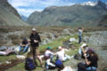
La ruta parte rodeando el Morro Negro. Se comenzar caminando por el camino vehicular que comienza a rodearlo en dirección opuesta al cerro mismo, hacia el oeste. Tan sólo 240 metros más adelante, surge un sendero peatonal hacia la derecha, en tanto que el camino vehicular continúa en dirección al Glaciar del Morado. El sendero enfila hacia el norte en medio de un escorial de rocas y boulders. Tras media hora de este paisaje eminentemente rocoso aparece majestuoso el Volcán San José hacia el este y se extiende el Valle de la Engorda en la misma dirección. Son los primeros metros de fértiles pastos los que dan nombre al valle. Al comienzo del valle hay un puente peatonal para cruzar el estero de la Engorda, aunque con la vista al frente uno tiende a cruzarlo más adelante, en cuyo caso, especialmente durante los meses de noviembre a enero, puede ser necesario sacarse los zapatos.
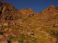
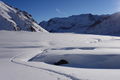
Se cruzarán varios cursos menores y se pasará -lamentablemente- muy cerca de las recientes instalaciones de la central hidroeléctrica Alto Maipo. Tras 2 kilómetros de caminata desde el inicio del valle de la Engorda se llega al pie de la quebrada sur (ver imagen), a 2615 msnm. Notar que también hay una quebrada norte. No se debe ingresar en la quebrada Sur, sino seguir en dirección Este hacia el San José. Junto a una gran roca se inicia el acenso.
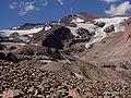
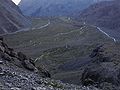
A partir de este lugar la huella es clara hasta el refugio mismo. Se comienza a ganar altura en forma pronunciada, pues el sendero zigzaguea por la empinada ladera, siguiendo a un pequeño curso de agua, que se debe cruzar. A 2700 msnm el sendero gira bruscamente hacia el norte, para volver a cruzar el estero. Luego da un nuevo giro hacia el sur, y se vuelve a cruzar el estero. A 2.887 msnm, ya más lejos de la húmeda quebrada, se vuelve a girar hacia el norte. Se debe entonces avanzar en esa dirección por un sector de menor pendiente, y volver a cruzar el curso de agua. Tras 600 metros de este sector más bien plano (ver imagen), el sendero, ascendiendo entre una zona de pasto, gira progresiva pero definitivamente hacia el sureste. Desde este punto, son 670 metros más de caminata hasta el pequeño pero confortable refugio de Plantat (3.130 m), ubicado a orillas del mismo estero que hemos venido siguiendo. Plantat corresponds also to the first stage of the climb of Volcán San José.
Refugio Plantat - Mirador del San José
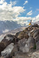
1 hour, one way If there is some time to spare, it’s advisable to carry on hiking along the same path to reach, after an ascent of about one hour, to the viewpoint of Volcán San José. The trail is well marked, as it used by the climbers on their way to the summit. Immediately after the cabin the path starts to climb close to the stream that feeds Plantat. After two minutes it separates from the stream to continue on a slope. Half an hour later, after 500 meters, a flat area is reached, easily distinguishable by a memorial plaque dedicated to a tragedy that took place in the Northern Icefield of Patagonia. The trail continues at the north of this little plain pointing to the volcano, following for a couple of minutes a gentle edge. Then, it crossed to the north of the slope and the inclination increases, to finally reach the edge that reveals the volcano in all its might. The area is recognizable by a hill of slabs right to the north (see image). Besides, the clear trail ends, and there are stone walls to protect from the wind. Fifteen minutes ahead, there is a cairn with a Chilean flag, although the view from there is rather the same. From the viewpoint ascend the hill of slabs to the north. That’s counterintuitive, as the natural choice would be to go on along the valley, flatter and easier. Once reaching the top (five minutes) the path that follows the edges is visible again. Ten minutes later, it leads to the cairn.
Expected time
Consider three hours from El Cabrerio, and a little more than two hours on the way back.
Permits / fees
On occasions, there is people charging CLP$1000 (US$ 1 as of April 2024) per person at El Cabrerío. It’s not clear whether this fee is legal, but for such a small amount is better to avoid problems. Sometimes they charge CLP$3000 (US$ 3.1 as of April 2024) per vehicle to park there as well.
Note: This fee applies to La Engorda Valley, not to Arenas Valley (the realm of Glaciar del Morado and so many others).
Recommendations
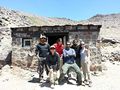
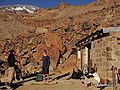
- The Plantat cabin was built in 1937 by Enrique Plantat and his sister Elizabeth, modelled after its alpine counterparts, due to their love for skiing. When inaugurated it boasted running water and a chimney. Today is maintained by their descendants and the mountain community. Please help us preserve it.
Hiring horses and/or mules
Roberto Molina and Katerina Cáceres offer horses and mules, departing from Baños Morales: +56287100051, +56991667566. Consider about CLP$15000 (US$ 15.3 as of April 2024) per day per horse.
Photo gallery
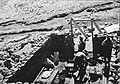
Construction of Plantat, 1937
Plantat 07-12-2013. Club Deportivo OKW V Region
Plantat half-buried by the snow. 22-11-09
Plantat, April 2010
San José viewpoint, April 2010
On the way to Plantat, April 2010
Looking to La Engorda from the top of the ravine, April 2010
Plantat half-buried by the snow. 21-11-09
Resting just before starting the ascent of the ravine. Looking west, November 04
Ravine
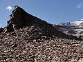
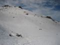
Morro Lajas (“slab hill”)
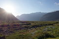
La Engorda during the summer, December 2016
La Engorda during the winter, June 2016
San Josecito, by Michel Baez

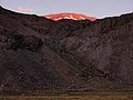
Sunset at Plantat. 21-11-09
Cerro Arenas from la Engorda. December 2014. By Jorge Alvarez Besa (@jorgealvarezbe)


