ENG:Glaciar del Morado

|
|
| |||||||||||||||||||||||||||||||||||||||||||||||||||||||||
 ATENCIÓN: No cometer el error habitual de confundir esta ruta con el trek al Glaciar San Francisco y la Laguna de Morales (a veces mal llamada Laguna del Morado), ubicado en el Monumento Natural el Morado ATENCIÓN: No cometer el error habitual de confundir esta ruta con el trek al Glaciar San Francisco y la Laguna de Morales (a veces mal llamada Laguna del Morado), ubicado en el Monumento Natural el Morado
|
When to visit
- Trekking:From October to May. During October and November there could be a considerable amount of snow to hinder the hike and make it impossible to reach the end of the road by car, but this will be rewarded with an even more beautiful landscape than in the summer months.
- Ski Touring: Between June and mid-October. Keep in mind that starting mid-August it might be necessary to carry your skis on first stretch. On the other hand, in mid-winter the car path is cut at Lo Valdés mining facilities, so you might have to start at Baños Morales.
Acess by Car and Road Condition
From Santiago you must take the G-25 to “Cajón del Maipo.” From the intersection at “Vizcachas” (0 km), its 47 kilometers of pavemented road until you reach the police control in “San Gabriel” (phones +56228611008 y +56228612290, in case you want to confirm the conditions of the road farther ahead, although the answers tend to be excessively “conservative”
The detour at “Baños Morales” the mountain village located at the north side of the “Volcán” river is found at the 65.1km mark (the pavement ends at 66.3 kilometers just before the plaster mine of “Lo Valdés.” between june and september this route may not be in the right conditions in there has been recent snow. If this is the case you must take the road to the left, cross the river and ascend a rough but brief uphill road to the village. Once there, you must park (the bus parking lot is a recommended place) and walk to CONAF, located west of the village crossing the creek.
After 1,6 kilometers from the fork at Baños Morales, the paved road ends and you will pass Lo Valdés mining facilities, where there is some accumulation from the gypsum mine. Six kilometers further from the fork to Banos Morales, and after the "Cuesta de los Afligidos" hill, you will reach a bridge that crosses the Colina river. Just 120 meters after this bridge you will reach "Cabrerío" (ver foto del lugar), to the left of the main path.
"Cabrerío" consists of basically a shelter that is frequented by herders. You can recognize it by a large rock with a small chimney on the top. Here is where the main road is abandoned by turning left on the fork in front of "Cabrerío" to venture into the Arenas mountain valley (set the kilometer marker to zero at this point).
This new dirt road (marked blue on the map) is kept by Alto Maipo hydroelectric power station, and is in excellent condition and good for any vehicle.
The power station has closed the old road on their work area, but has opened a new one that goes further up. On kilometer 6,5 it joins with the old road and reaches a nice plateau, popularly known as "El Choriboulder" due to the large amount of climbing boulders in the area, and a bouldering event that took place here in 2004.
When the road begins to separate from the valley and ascend on the hillside (kilometer 8,05 from Cabrerio), find a wide space to park and begin the hike.
If you drive a 4x4 you can continue for two more kilometers on the old road in very bad condition. The drive here is almost at walking pace, so the usefulness of this road is debatable.
Access by Public Transportation and Autostop
Plantilla:Public transportation Cajon del Maipo
If you take the bus to Banos Morales, there are good chances to make the autostop up to Cabrerio. Getting an autostop from Cabrerio to the parking space (red route) is harder but possible, especially during the summer weekends. If you decide to take the bus and you don't want to try autostop, walk the yellow route.
Route Description
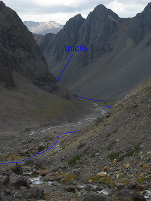
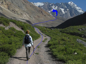
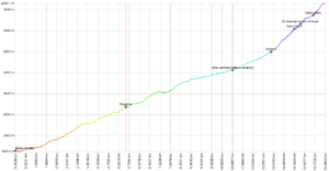
Having parked the car, abandon the main route to take a car path in bad condition, that will become progressively in very bad condition. On the first two kilometers, the path will go by the back of the valley on the west side of the river, where it will slowly gain altitude. At 2.805 AMSL you will pass next to a flag.
Afterwards, the path will begin to distance itself from the main river of the valley, each time higher on the mountain hillside. The slope becomes considerably steeper than on the first stretch of the trek. You will have to continuously cross small creeks on the path. The route is always visible since most of it takes place on the old car path.
Luego habrá que cruzar un estero (3.039 msnm) que viene del noroeste, y comenzar a remontarlo por su flanco este (flanco derecho, según el sentido de marcha). Es el tramo más empinado
Poco después de cruzado el pequeño estero, a 3.079 msnm, se llega al fin absoluto del camino vehicular (Nota: en marzo de 2013 aún era posible llegar a este punto en vehículo, pues un Suzuki Samurai estaba estacionado ahí). Pero llegar hasta acá en vehículo es muy difícil y arriesgado: en la parte más alta, este antiguo camino vehicular no es más que una simple huella con grandes piedras sueltas. (ver foto del lugar hasta donde se puede llegar en vehículo 4x4)
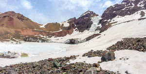
A pesar de que el sendero es notorio, esta zona estará cubierto de nieve hasta principios del verano. ver imagen La laguna está situada en una olla que se forma al oeste de este valle, por lo que se debe avanzar en esa dirección.
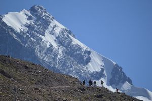
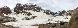
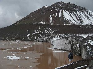
Luego viene una zona más plana, siempre por el flanco derecho del estero. Éste se debe cruzar por segunda vez en esta zona plana, a 3.150 msnm, y luego remontar la morrena final, donde se vuelve a ganar pendiente. El sendero no enfrenta la pendiente en forma directa hacia el oeste, sino oblicua, en dirección noroeste. Inmediatamente al final de la subida nos recompensará la espectacular panorámica del glaciar colgante del Cerro Morado, de sus glaciares aledaños y de su laguna con témpanos.
Retornar por la misma ruta.
Tramo Baños Morales - Empalme ruta principal (para Randonnée o transporte público)
Si al llegar a la yesera de Lo Valdés el camino está cortado (lo que es probable entre principios de junio y septiembre) habrá que volver y tomar el desvío a Baños Morales, y avanzar a lo largo de la ribera norte del río Volcán. Son 5,6 kilómetros a lo largo de la ruta amarilla, por un antiguo camino vehicular -muy apropiado para esquiar- hasta el empalme con el camino que parte desde el Cabrerío, subiendo desde los 1860m hasta 2275m. Ello debiera tomar poco menos de dos horas. Desde ese empalme, son 5,4 kilómetros más a lo largo de la ruta azul hasta el inicio descrito en la sección anterior y que se puede alcanzar en vehículo cuando no hay nieve. Este tramo exige subir desde los 2275m hasta los 2628m, lo cual debiera tomar otra hora y media al menos.
Panorama 360° Virtual de la La Laguna del Morado
Imagen obtenida desde el centro de la Laguna del Morado a mediados de octubre 2014
Tiempo esperado
Si se llega hasta el final de la ruta, a ritmo normal la caminata debe tomar 3 horas de subida y 2,5 horas de bajada. Agregar 1 hora adicional si se empezó antes del sector de "choriboulders"
Permisos / Tarifas (nuevo procedimiento, instaurado en julio de 2019)
Las solicitudes para acceder al Valle las Arenas se hacen a ParqueArenas@gmail.com en día hábil hasta las 17 hrs y con a lo menos 24 hrs de anticipación. Sin excepción. Indicar:
- Nombres, Rut o pasaporte.
- Fechas de ingreso y salida (Las visitas se autorizan solo por la fecha indicada. Si van por mas días señalar fecha con un máximo de 3 días)
- Descripción de actividad.
- Placa patente.
- Hay que utilizar el área de estacionamiento designada ubicada en la garita junto a Puente Engorda. (Otras áreas de estacionamiento están en una zona de avalancha peligrosa). Se puede solicitar permiso para dejar pasajeros o equipo en el "camino turístico" ubicado junto al campamento de Alto Maipo, pero todos los vehículos deben permanecer en el estacionamiento designado.
Contratar Guías
Es posible realizar este trekking en forma guiada:
 Trekking Andino: Viajes personalizados de alta calidad a atractivos Naturales, Patrimoniales y Culturales
 Contacto: info@trekkingandino.cl
 Facebook: Trekking Andino
 Instagram: @TrekkingAndino
 Teléfono: +56 9 78993379 (WhatsApp)
- Tralov Adventures: Private Hiking Tours in The Andes with certified guides / Tours privados y trekkings en Los Andes
- Contacto: contacto@tralov.com
- Facebook: Tralov Adventures
- Teléfono: +56 9 4949 1984 (WhatsApp)
- Contacto: contacto@anoka.cl
- Facebook: Anoka Experience
- Teléfono: +56978886115 (WhatsApp)
- Denomades.com: Tours y trekkings regulares y privados en el Cajón del Maipo y otros destinos. Contacto directo con los mejores operadores locales.
- Contacto: reservas@denomades.com
- Teléfono: +56 229551857
- Facebook: Denomades.com
- Contacto: ecotrekkingchile@gmail.com
- Facebook: Ecotrekking Santiago de Chile
- TripAdvisor: Ecotrekking Chile
- Teléfono: +56966028918 (WhatsApp)
- Ecochile Travel: Regular and private trekking trips at the Andes.
- Contacto: info@ecochile.travel, (56- 02) 25708826
- Flecha Extrema: Private Hiking Tours / Highmountain Expeditions around Santiago - Experience the Andes
- Contacto: contacto@flechaextrema.com, +56 9 65 61 72 77
- Facebook Turismo Flecha Extrema
- Teléfono: +56965617277 (Whatsapp)
- AndesBrown: Caminatas y Excursiones a la montaña central de Chile. Grupos guiados, guías federados.
- Contacto: info@andesbrown.cl, brown.fernando@gmail.com
- Teléfono +56988382014.
- Cajonoutdoor: Treking, cabalgatas y excursiones en todo el cajón del Maipo. Transporte de pasajeros desde hotel o aeropuerto al destino elegido. Guías bilingües expertos en la zona.
- Contacto: contacto@cajonoutdoor.cl
- Teléfono: +56991940429 - +56975275503.
Contratar cabalgatas
Es posible contratar caballos con Roberto Molina y Katerina Cáceres, partiendo desde Baños Morales. Se debe llamar a los teléfonos +56287100051, +56991667566. Los valores fluctúan en torno a los CLP$15000 (US$ 15.6 as of November 2024) por caballo.
Pronóstico del Tiempo
Galería de fotos
Glaciar del Morado visto desde la ruta de ascenso al Cerro Arenas. La laguna aparece congelada al pie del glaciar, pero se observan las orillas iniciando el deshielo. Noviembre de 2012


