Diferencia entre revisiones de «ENG:Refugio El Bolsón»
m (Texto reemplazado: «|Duración=» por «|Duracion=») |
m (Joaquin.baranao trasladó la página Refugio El Bolsón (english) a ENG:Refugio El Bolsón) |
(Sin diferencias)
| |
Revisión del 20:49 30 may 2018
|
|
|
| |||||||||||||||||||||||||||||||||||||||||||||||
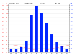
Best time of year to go
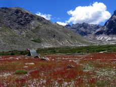
All year round. However, the place is especially beautiful in May when the leaves of the southern beech trees have turned dark orange and red. However, it can be a little bit rainy around then
Getting there
By car
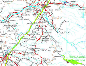
Exit the Panamerican Highway (Ruta 5 Sur) to the East, via the town of Molina, then follow the K-175, followed by the unpaved K-275 until you reach the small village of Radal, which is situated 72 km to the southeast of Molina, and serves as the gateway to the national park. You then have to keep following the same road uphill for around another 10 km in order to get the CONAF park rangers' office in Parque Inglés
In order to get to the village of Radal and the national park from Talca, you have to leave the city to the East, passing through the settlements of Lo Beño and La Placeta on the way. The first 30 km of this route are paved. The remaining 40 km consist of travelling along a decent-quality gravel road. The road does get narrow in certain spots but it does have passing places, which you might have to pull into, from time to time, in order to allow oncoming traffic to go past you.
By public transport and hitchhiking
From Santiago, the only bus company that goes directly to Molina is PULLMAN DEL SUR. These buses leave from the "Terminal Alameda"/"Terminal de Santiago" complex , which is located next to the "Universidad de Santiago" Metro station. It isn't possible to buy a return ticket from a Santiago but the price of a one-way ticket should cost CLP $4,000-$5,000
During the peak season -- largely defined, in this case, as from Christmas time to the end of February -- buses go all the way to Parque Inglés from Molina. These local buses leave from the bus terminal, which is located about half a block away from Molina's main square (Plaza de Armas). If you have any enquiries about the buses then e-mail "Buses Hernandez" buseshernandez@gmail.com. Address: Calle Maipú 1735, Molina. Bear in mind that, for about nine and a half months of the year, these buses only go up as far as the village of Radal, which serves as the entrance to the protected area.
A second option is "Buses Radal Siete Tazas", whose buses GENERALLY only run during the months of January and February, and on long public holiday weekends in December.
Both companies have Facebook pages, in Spanish, where they publish their bus timetables
If you miss your bus to the national park and are short of time, you can hitchhike from Valdesina, which is a small settlement on the road between Molina and Radal. You can take a minibus or ("micro") to Valdesina. These minibuses leave from just outside Curicó bus terminal and make a stop at Molina bus terminal on the way. It's just a case of riding one as far beyond Molina as it will take you, and then getting off the minibus before it turns around and heads back the other way. If you can't find a minibus to Valdesina, then just hop on one that has a destination sign on the front that includes the place name "TRES ESQUINAS". These minibuses can at least drop you off on the Molina-Radal road -- specifically, in the settlement of La Palmilla, which is about three kilometres less far up the road than Valdesina. Either way, make it clear to the bus driver that you plan on hitchhiking to Radal/Las Siete Tazas/Parque Inglés, so that he knows where to drop you off.
Bear in mind that if you are visiting the national park, without a vehicle, outside of the peak tourist season, then even in the BEST case scenario, you will have to hitchhike into it from the village of Radal.
Description of the route
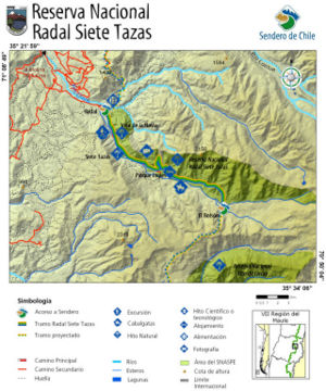
The starting point is the CONAF rangers' office at Parque Inglés (km 0 of the trek - 1100m above sea level). Start the walk by passing around the back of the CONAF base through a turnstile following the signs to the trails. After you get out of the CONAF base, you need to turn right onto a dirt road which then bears around to the left. Within 150 m from the CONAF base area, you'll see a path, which exits the dirt road to the right, along with a route sign pointing towards Refugio El Bolsón, and that it's four hours' walk away. This is the trail you want to take. You have to keep following it until you get to Refugio El Bolsón, ignoring all of the secondary paths that you'll see branching off to the sides of the main route as you go along (most notably, Sendero Mala Cara and Sendero La Montañita). Try not to forget this! 🙂 By the way, "sendero" means "path" in Spanish.
On the way, you'll see signs saying "3 hours to go", "2 hours to go" and "1 hour to go" -- albeit not in English -- which will give you some idea of how close you are to your destination. Obviously, the time periods that appear on these signs are only rough estimates but they should be reasonably accurate for a person walking at a normal pace.
Most of the signs along the route to Refugio El Bolsón are clearly marked and there aren't very many places where you can expect to get lost easily.
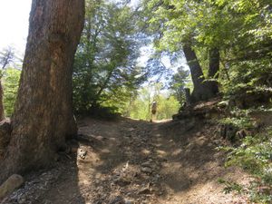
The opening section of the route is very pleasant. It passes through dense forest and has a relatively flat gradient. After about 20 minutes of walking, you'll get to a small clearing (km 2.4 - 1212m). A few steps further on is a small stream, which gets dried up by the middle of summer. You'll then pass a quincho [= a Chilean wooden gazebo] and a wooden sign with a map on it just ahead of it, in the same clearing. You'll also go past the entrance to Sendero Mala Cara less than 10 minutes later. In km 3.7 of the walk (altitude 1282m), you reach a fork in the trail . You need to take the right fork in order to keep heading towards Refugio El Bolsón instead off veering off left to Sendero Montañita. There are signposts there to help you out. 330 metres further along, you have to cross another stream.
You then have to keep following the trail as it winds its way uphill, through the southern beech forest. After another hour's walk, the scenery begins to change. The vegetation thins out considerably and turns into scrubland.
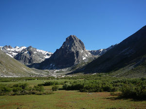
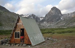
At km 7.3 of the trek (1520m above sea level) you have to cross a moderately wide stream, which flows down from Cerro Piuquenes. Just 600 metres further ahead, the trail arrives at the Río Claro, which carries a much greater volume of water and has a very powerful current. DO NOT ATTEMPT TO CROSS THE RIVER, on this particular trek. Just keeping walking along the north bank of it. Further on, the climb starts to get a little bit steeper. After a few more minutes of walking the Valle del Indio starts to open up on you. You'll see ñirre shrubs all around, and should be able to make out Cerro Tres Puntas and the Salto del Indio (a waterfall), in the distance. About 45 minutes after you cross the stream, you should get to the small CONAF shelter: "Refugio El Bolsón" [km 10.1 -- Altitude: 1686m], which is also a camping area. There is plenty of space to pitch your tent close to a small brook that flows through the site. This camping spot also offers an outstanding view of a dramatically steep and rocky peak -- the appropriately-named, Colmillo del Diablo [= The Devil's Fang], which is located just two kilometres to the North.
From Refugio El Bolsón, you can carry on trekking to:
- Laguna Las Ánimas: 2 to 3 days round trip
- Cerro Las Ánimas: 2 to 3 days round trip
- Laguna Mondaca + the hot springs nearby: 4-day round trip
- Sendero del Cóndor + hot springs : 4-day round trip
- Cerro Colmillo del Diablo
- Laguna Manantial Pelado
Admission fees for Parque Nacional Radal Siete Tazas
(Per day. PRICES IN CHILEAN PESOS)
| Chilean residents |
Others | |
| Adults | $2.500 | CLP$5000 (US$ 5.2 as of November 2024) |
| Children (6 to 8 years of age) | $1.000 | CLP$2500 (US$ 2.6 as of November 2024) |
| Senior Citizens | $1.200 | information unavailable |
Recommendations
- Before setting off on your trek, make sure you inform a ranger, at the CONAF office in Parque Inglés, of the route that you intend to follow. This is isn't just very important in case of emergency, it's also a great way to get tips and insights about the trail from the knowledgeable CONAF staff. (Obviously, some grasp of the Spanish language on your part will allow you to get a lot more out of the conversation 😉 )
- In the national park and on the way to it, there are places where you can camp and load up on water.
- You can buy food in Radal, but it's a better idea to do so in Molina
- Try to avoid lighting fires in the campsites
- There are waste bins in the campsites. Remember to bring trash bags with you .
- It's harder to access the trail during the winter months because it can snow a lot along the route
- If you choose to camp in Parque Inglés during the peak summer period, then make sure you keep an eye on your possessions. Opportunistic theft is certainly not unheard of around there during the busy tourist season.
- If you are looking for more information, click on this link, where you'll find a complete help guide.
Galería de fotos
To see the full list of 690 routes of trekking and mountain climbing in Chile in spanish, click here
| ||||
| Trekking Atacama | ||||
| Trekking Norte Chico | ||||
| Trekkings: | ||||
| Cumbres: | ||||
| Trekkings: | ||||
| Cumbres: | ||||
| Trekkings: | ||||
| Cumbres: | ||||
| Trekkings: |
| |||
| Cumbres: | ||||
| Trekking Rancagua | ||||
| Trekking San Fernando | ||||
| Trekking Curicó | ▲ ENG:Laguna de Las Ánimas ▲ ENG:Refugio El Bolsón | |||
| Trekking Talca | ||||
| Trekking Linares | ||||
| Trekking Chillán | ||||
| Trekking Concepción | ||||
| Trekking Los Angeles |
| |||
| Trekking Zona lacustre | Trekking Temuco | |||
| Trekking Valdivia | ||||
| Trekking Osorno | ||||
| Trekking Puerto Montt | ||||
| Trekking Chiloé | ||||
| Trekking Patagonia | Trekking Chaitén | |||
| Trekking Coyhaique | ||||
| Trekking Cochrane y Villa O`Higgins | ||||
| Trekking Puerto Natales | ||||
| Trekking Punta Arenas | ||||
| Trekking Tierra del Fuego | ||||
| Trekking Isla de Pascua | ||||
| Trekking Archipiélago Juan Fernández | ||||


