![]()
Diferencia entre revisiones de «GPT20 (Volcan Antillanca)»
(→Access to Route and Return) |
(→Images) |
||
| Línea 145: | Línea 145: | ||
=Images= | =Images= | ||
| − | |||
| − | |||
| − | |||
| − | |||
| − | |||
| − | |||
| − | |||
| − | |||
| − | |||
| − | |||
| − | |||
| − | |||
| − | |||
| − | |||
| − | |||
| − | |||
| − | |||
| − | |||
| − | |||
| − | |||
| − | |||
| − | |||
| − | |||
| − | |||
| − | |||
| − | |||
| − | |||
| − | |||
| − | |||
| − | |||
| − | |||
| − | |||
| − | |||
| − | |||
| − | |||
| − | |||
| − | |||
| − | |||
| − | |||
| − | |||
| − | |||
| − | |||
| − | |||
| − | |||
| − | |||
| − | |||
| − | |||
| − | |||
| − | |||
| − | |||
| − | |||
| − | |||
| − | |||
| − | |||
| − | |||
| − | |||
| − | |||
| − | |||
| − | |||
| − | |||
| − | |||
| − | |||
| − | |||
| − | |||
| − | |||
| − | |||
| − | |||
| − | |||
| − | |||
| − | |||
| − | |||
| − | |||
| − | |||
| − | |||
| − | |||
| − | |||
| − | |||
| − | |||
| − | |||
| − | |||
| − | |||
| − | |||
| − | |||
| − | |||
| − | |||
| − | |||
| − | |||
| − | |||
| − | |||
| − | |||
| − | |||
| − | |||
| − | |||
| − | |||
| − | |||
| − | |||
| − | |||
| − | |||
| − | |||
| − | |||
| − | |||
| − | |||
| − | |||
| − | |||
| − | |||
| − | |||
| − | |||
| − | |||
| − | |||
| − | |||
| − | |||
| − | |||
| − | |||
| − | |||
| − | |||
| − | |||
| − | |||
| − | |||
| − | |||
<gallery> | <gallery> | ||
Revisión del 10:09 2 dic 2023
Add a new log entry always on top in the appropriate season sub-chapter and use format:
* Start Date to Finish Date (use Format YYYY-MMM-DD) / Duration in Days / Hiking or Packrafting / Travel Direction (SOBO for Southbound or NOBO Northbound) / Chosen Route and/or Option Name (RR for Regular Route) / Names or Alias
Summary with remarks to route that are considered useful for other hikers and packrafters. Include alerts, suggestions and personal perception of attractiveness and difficulties.
Add a sub-chapter by placing two "=" before and after the new sub-chapter heading ('==Sub-Chapter Heading==').
Contenido
Section Log, Alerts and Suggestions
Season 2025/26
Season 2024/25
Season 2023/24
Season 2022/23
- 2023-Jan-29 / 3 days / hiking / RR / NOBO / Frank
The river at Las Gaviotas was easily fordable in late January, knee deep at the ford. Below the ford it runs deep into the lake. RR NOBO from Las Gaviotas remains very overgrown, machete highly recommended. I also used gardening gloves which help to grasp & break thorny plants. Many fallen trees, it gets better as you go up but is still slow going. Took me 9 hours to get to the treeline from Las Gaviotas ferry. The alternative route is likely to be a lot worse. There was still a lot of snow on Pass 1910 metres. I tried a few options but couldn't find a way over. The rock gendarme above the pass is not climbable - I tried, it starts as a scramble but goes up to a pinnacle. Ripped my pack on the sharp volcanic rock. I retreated & went around below the pass on OH-CC-A@20-A-001. It's a bit longer but fairly easy, there is a faint trail. Conaf are working on reopening the trail to Pampa Frutilla. It's open for 12KM SOBO from Conaf Anticura, easy walking & super fast. Then for 4KM it's overgrown but passable with moderate bush bashing & you are soon above treeline on RR. I didn't go to Strawberry Fields but suspect the route will be severe until Conaf cut it back. The slowness of the route means water becomes a serious issue. I was lucky to find one water source at 1600 metres from snowmelt (dirty with sand & needs to be filtered) but it's not reliable. There is water at bridge/camp 2.5KM after Conaf Anticura & then no permanent source until you are a few hours below treeline going down to Las Gaviotas. So carry a lot or consider splitting the trail in two with entry/exit at Antillanca ski station.
Season 2021/22
- 2021-Dec-02 / hiking / NOBO / Alex Abramov
We walked from Crater Raihuen (Ski Center Antillanca) to Anticura in one day. There was not much snow, but we faced the problem of bypassing the rocky gendarme on the ridge along the frozen snow slope. In running shoes, it looked unsafe given the steepness and length (over 300m) of the slope. So we decided to go around the ridge along the north side (similar to the GPT20 variant D). It is a simple, fast (about 2 hours) and logical route, accessible in any weather and in any condition. We found the trail between Pampa Frutilla and Antikura in ok condition: some easy bushwhacking and a dozen sections with fallen trees. It may feel harder with a heavy load. No water between Ski Center Antillanca and almost finish! We did not go to Pampa Frutilla Lakes
Season 2020/21
Season 2019/20
- 2020-Feb-22 / 2 days / RR SOBO and optional route to Antillanca / Martina & Ivo
Yes, we gave us that overgrown shit and we cannot believe Martin did that both ways! At least we could skip the first 3 km of the overgrown trail by starting on the Ruta International towards Argentina for 2.9 km and then turning right onto a former minor road which meets the regular route after 800 meters. We spent the night (and a day off due to exhaustion) at Pampa Frutillar, which is a 7.4 km detour to strawberry paradise and two pretty lagunas (optional route 19-05-#001). The ascent to the summit and the view from there were the most spectacular ones so far! Still a bit snow left, but no problem. As Matus said "hell starts" on the last 4 km before Las Gaviotas and we thought we already had our personal hell on the first 14 km, we decided to end this section in Antillanca, where we found accommodation. From here you need to walk or to hitchhike to Aguas Calientes for busses to Osorno.
- 2020-FEB-13 / hiking / Optional Start @ Antillanca / Tyler Wood
I opted to skip the first 13 km bush bashing noted by martin and hitched up to Antillanca with good luck. From there I slept in the crater at the base of Casa Blanca and summited the next morning. The same day went all the way down to the end of the section via the RR. Huge day, but definitely do-able with the optional start. As far as the bush bashing, it’s all good until near the end of RR-TL-V@20-27.1+6.3. Yeah, then it really tricky. Expect at least 2-3 hours to get through the thousands of downed trees. The madness continues pretty much all the way to the bottom. We camped on the beach and it was super beautiful. I decided to skip section 21 due to the $100 ferry across todo santos. A ferry leaves Las Gaviotas around noon to El Poncho for just 250 pesos. Ask locals for exact time for the ferry. From el poncho a bus comes (times with the ferry) that runs directly to Osorno. I got off at an intersection where I could hitchhike to Cochamo. (Huge hitch).
- 2020-JAN-01 - 2020-JAN-02 / 2 days / Hiking / SOBO / Option 2 from the ski station to the Volcanoe, RR from the volcanoe to waypoint Div133,Option 1 down to Lago Rupanco / Linda
Beacuse the pass of the Volcan is now impossible (view Martin feedback), I decided to hike only the southern part of this section = starting from Aguas Calientes (Buses all day long from Mercado of Osorno directly to Agua Calientes, which is a good spot to rest with a camping) to the ski station and then to Lago Rupanco :
1st part = Option 2 from the ski station to the Volcanoe
2nd part = Regular route from the volcanoe to waypoint Div133
3rd part = Option 1 down to Lago Rupanco
The 2 first parts are simply amazing = the view both on Volcanoe Casablanca and the valley where lies Lago Rupanco
BUT I won't recommend the 3rd part which is indicated on the GPS as overgrown. And it was crazily overgrown!!! I did it without a machete and it took me about 7 hours to come across 2km of very very wild forest, full of flourishing bamboos, that is very strong. As there is no track, I had to stick very closely to my compass (South / South West) to be able to join the end of the regular hiking track (that leads to the Lago Rupanco) which was also full of huge dead trees!!!!
I don't know how overgrown is the Regular Hiking route through this same forest. But be prepared to something very very tough.
- 2019-DEC-19 - 2019-DEC-20 / 2 days / hiking / SOBO / Martín Lizondo /
The trail from Conaf is extremely overgrown, even after the first bridge. There’s no minor road anymore. Guards offer you a “machete” to clean the path. Expect super ultra slow hiking (2 km p/h) the first 12 km. From then, as the trail reaches higher altitude, it becomes very easy to walk.
- 2019-NOV-09 / hiking / Sophie & Hendrik
The river crossing directly north of Las Gaviotas is difficult right now. It is highly recommended to organise a boat which takes you over the lake. (It is just a short distance and won't cost much.)
- Comment Jan Dudeck: Arranging this boat transfer northbound is probably easier than southbound (there are several settlers south of the river but not north of the river). So hiking section GPT20 southbound might not be feasible right now.
At this date, the pass to Rupanco is all covered by snow, impossible to cross with regular gear, due to the snow fall the last few days. The optional route to avoid snow is also impassae. Pro: views are very nice. I had to return to Anticura and hitchike back to Entre Lagos.
Season 2018/19
Season 2017/18
- Route description by Kara Davis after Season 2017/18:
A small road leads past the CONAF building and winds through several Cabañas until reaching a trail. This trail, although fairly obvious and easily followed, becomes more overgrown as it travels deeper into a bamboo forest. The density of obstructions (foliage, fallen logs, etc.) makes hiking slow. Around 1.100 m, the forest begins to open up and there are several small campsites. At treeline, the trail widens into a old gravel roadbed. Be careful not to miss the turnoff onto a small trail to the right that dips back into the trees, as the regular route does not follow this roadbed for long. At the bottom of the descent, the trail crosses a meadow and climbs back up to treeline. The trail on Volcán Casablanca is not obvious, but there are several stone cairns (and the occasional bamboo pole) sparsely spaced along the path. Alternate Route: After descending from the Volcano, we decided to hike along the mapped trail located to the east of the GPS route. We quickly discovered the trail was wiped out by a landslide, and involved a steep descent to a faint track. The track winds through some open forest and joins a large black river bed. At the end of the open river bed, reenter the trees and follow a fairly obvious but overgrown path. Camping is very difficult to find until rejoining the regular route. I would seriously recommend sticking to the regular route as shown by the GPS track; this alternate was slow going and painful.
Season 2016/17
Resupply and Accommodation
Resupply and Accommodation in nearby Towns
- Shopping: Food
4 big supermarkets in Osorno all near the bus terminals Puerto Octay has a limited selection for resupply, but there are several restaurants and a good quesería.
- Shopping: Fuel
In Portal Osorno shopping centre Doite shop has camping gas screwgate canisters.
- Accommodation: Camping
El Encuentro campsite with cabanas just behind the beach at Las Gaviotas, camping is 10,000 pesos. Run by Marcelo who is friendly & helpful. He has a boat so might be able to take you across the river NOBO for a small fee. About 3KM beyond Puerto Buey on the road out is Entre Rios camping, cabanas & small shop, basic camping for 5000 pesos, tap water but no shower or toilet
- Puerto Octay has a limited selection for resupply, but there are several restaurants and a good quesería.
Resupply and Accommodation along the Route
Transport to and from Route
Access to Route and Return
- 2020/ Tyler Wood
A ferry leaves Las Gaviotas around noon to El Poncho for just 250 pesos.
- On Monday, Wednesday & Friday a bus goes to Puerto Poncho from Osorno main terminal at 12:30 & connects to the ferry, getting you to Las Gaviotas at 16:30.
- Ferry Las Gaviotas-Puerto Poncho :
Monday 7:00 & 16:30 / Wednesday 2:30 PM / Friday 7:00 & 16:30 / Sunday 15:00 Ferry connects with a bus. Buses may go to Entre Lagos, sometimes Puerto Octay or more often to Osorno. Buses every half hour Entre Lagos-Osorno. There should be an unscheduled ferry Las Gaviotas-Puerto Buey Monday, Wednesday, Friday & Sunday at 8PM but this ferry does not connect with a bus.
- Ferry Puerto Poncho-Las Gaviotas:
Monday 8:00 & 15:30 / Wednesday 15:30 / Friday 8:00 & 15:30 / Sunday 16:00 No bus on days the ferry doesn`t run. Hitching is difficult, there is a gravel road all the way to Las Gaviotas but not much traffic except on weekends.
- Comment by Jan Dudeck:
There is a local who lives in the house on the lake shore northwest from the mouth of the river whom may offer passage on his personal row boat for payment. You may see his boat tied to a tree near the lake. Town: Puerto Octay to Osorno/Puerto Varas/Puerto Montt There is a boat ferry that picks passengers up at Las Gaviotas, which is the beginning of GPT21, and travels to Puerto Buey. It is about a 50 minute ride and 200 CLP. The boat only runs two or three times a day. It is also possible to walk the distance, about 10 km down the road on the south side of the lake. From there you can catch a bus, which also only runs a couple of times per day, to Puerto Octay with connections to Osorno (which is the better resupply option). It is easy to catch a bus to Osorno, Puerto Varas, or Puerto Montt which all have large supermarkets. To my knowledge the boat runs not daily. Please check with locals and provide current information to the ferry Las Gaviotas.
Permits, Entry Fees and Right-of-Way Issues
Links to other Resources
Retired Section Article GPT20 - Volcán Antillanca
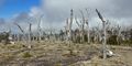
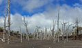
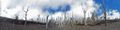
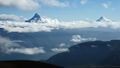
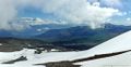
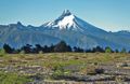
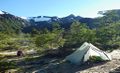
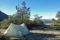
Images
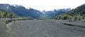
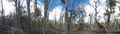
thumb|
thumb|
thumb|
thumb|
thumb|


