GPT10 - Laguna El Barco
| All GPT sections (click to show) |
|---|
|
GPT Section Articles
|
Recent Alerts and Suggestions
Season section log
- Start Date: January 12, 2020
- Section: GPT 10 Southbound
- Duration: 2 Days
- Name/Alias: Ian Hikes
- Overview: This section was well marked/distinguished relative to all the other sections on thus far. There were many Puestos along the way as well. This was also the first section where the araucaria tree is very prevalent across the landscape. This section was my final section on the GPT and the araucaria trees and the lush green landscape provided good contrast to the semi-desert climate south of Santiago de Chile.
- Difficulties: There was a small 12km ish section without water close to the pass.
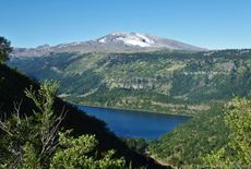
- Highlights: Change in landscape. Great views of the many volcanoes in the area.
- Please feel free to reach out to me with any questions at ultratrailca@gmail.com
- 2020-Jan-15 / Maddie & Tom / Regular route southbound
1.5 days. The trail was in good condition and we didn’t experience any issues. Possible to resupply at Guallalí but the selection isn’t huge (pasta, dry soups, crackers, tuna etc). If you are looking to bus into Lonquimay, it was leaving at 5:30AM the next morning for us (but we didn’t take it).
- 2020-Jan-10 / Martina & Ivo / Regular route southbound
1.5 days. Easy trail and navigation. We got in this really bad weather too. Storm and ice at the pass. In Guallali we had coffee and sopapillas at the carabinieros and spent the night at the same place as Matus, Anna and Linda. We took the bus at 05:30 towards Los Angeles and are staying in Ralco for resupply and drying.
Linda 2019 December 25 and 26 Southbound 2 days = Regular hiking route to the end
- Nice hike with no major difficulties. The plateau with the araucarias after the pass is amazing!!!
- No river when you leave the valley toward the pass and then down to the other valley BUT, as I wanted to sleep on this plateau (25 km after the start of the section) I found a small river 300 meters on the right from the regular track and camped at this place : S37,895511° O71,308919° Wonderful sunset!!!
- In Guallali, end of the section, lodging, food and mini shop. Lodging at the way point Minishop very nice = guesthouse with diner and breakfast for 20000 CLP. Very nice family!!!!
- 17.12.19 / Sophie & Hendrik / 2 days (11 walking hours) / Northbound / Regular Hiking Route with hitch hiking between Guallali and Laguna el Barco.
In total we were 3.5 days on the trail, of which we spend 1 in the tent due to bad weather. The 0.5 day we had left from arriving in Guallali we spend buying food and hitch hiking to the campground at Laguna el Barco. We did so because we expected rain soon and wanted to camp it out. Also we were not too keen for the gravel road part.
We liked: Nice araucaria trees, an amazing sunset we saw a tad south of Laguna Llai and after section 11 and 12 the easy terrain.
We did not like so much: The horsflies.
- 4-Jan-2020 / Matus & Anna / Regular SOBO
GPT09 and GPT10 Season section log. We combined these two sections. It took us 3.5 days via regular trail SOBO. Trail in both section is in good condition. There is snowfield in first pass as was mentioned. We went left, but it would be worth to check is it's possible to go through rocks on the right as it seems much shorter. Water is not marked on a map but there is a stream before the pass. Resuply in Trapa Trapa is very limited. They had few tunas, other caned fish, some pasta, flour, cola, crisps... We didn't check for accomodation. We stayed in a paid campsite at Laguna el Barco for 5000 both. Around 8 there was a woman selling bread and sweet pastry, but mind that it was weekend. Resuply in Guallali again very limited. They have tunas, caned fish, pasta, oil, crackers and bit more. We are staying in a house next to the shop.
Summary Table
| GPT10: Laguna El Barco | Hiking | Packrafting | |||||
| Group | C: Zona Pehuenche | Total | 47.6 km | 14 h | - | - | |
| Region | Chile: Bío Bío (VIII) | Trails (TL) | 31.0 km | 65.1% | - | - | |
| Start | Trapa Trapa, Posta | Minor Roads (MR) | 14.2 km | 29.9% | - | - | |
| Finish | Guallali (Carabiñeros) | Primary Roads (PR) | 2.4 km | 5.0% | - | - | |
| Status | Published & Verified | Cross-Country (CC) | - | - | - | - | |
| Traversable | Dec - Mar (Maybe: Nov, Apr) | Bush-Bashing (BB) | - | - | - | - | |
| Packraft | Deployable | Ferry (FY) | - | - | - | - | |
| Connects to | GPT09, GPT11 | Investigation (I) | - | - | - | - | |
| Options | 61 km (2 Options & Variants) | Exploration (EXP) | - | - | - | - | |
| Hiking | Packrafting | Total on Water | - | - | |||
| Attraction | 4 (of 5) | - | River (RI) | - | - | ||
| Difficulty | 2 (of 5) | - | Lake (LK) | - | - | ||
| Direction | Both ↓↑ | - | Fjord (FJ) | - | - | ||
| Comment | - | ||||||
| Character | Araucaria Forest, Mountain Pastures, Pehuenche | ||||||
| Challenges | Exposure to Elements, Lack of Drinking Water | ||||||
Satellite Image Map
Elevation Profile
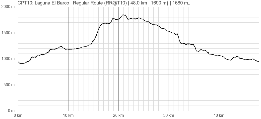
Elevation Profile of Regular Hiking Route
Section Planning Status
Recommended Travel Period
Benefits of Hiking and Packrafting
Recommended Travel Direction
Section Length and Travel Duration
Suitable Section Combinations
Section Attractiveness
Section Difficulty
Resupply
Resupply Town
Shopping: Food
Shopping: Fuel
Shopping: Equipment
Services: Restaurants
Services: Laundry
Services: ATM and Money Exchange
Accommodation: Hostals and Hotels
Accommodation: Cabañas
Accommodation: Camping
Transport: Ground Transport
Transport: Ferries
Transport: Shipping Services
Resupply on the Trail
Location, Names, Available Items and Services
Access to Route and Return
Access to Start
Return from Finish
Bus Guallali - Ralco - Santa Barbara - Los Angeles 05:30


