![]()
Diferencia entre revisiones de «GPT21 (Lago Todos Los Santos)»
(→Transport to and from Route) |
(→Season 2022/23) |
||
| Línea 42: | Línea 42: | ||
We took the bus from Puerto Montt to Osorono. Unfortunately, the morning bus to Lago Rupanco was already gone. There's supposed to be another one at 4:00 p.m. we decided to take the bus to Entre Lagos and hitchhike from there - which wasn't easy. For a long time nobody gave us a ride on the Minor Road in the direction of Lago Rupanco. In the end we got some shorter rides and hiked some parts too. We stayed the first night at Camping Las Nalcas in Puerto Rico. No official camping but it is allowed to set up the tent on the private land for 4000 pesos. Mini market with simple equipment is right next door. Hike to Laguna Los Quetros was easy and well marked. Camping was free because nobody was there. The next day we went on to Lago Todos Los Santos. At S 40.98259 / W 72.16572 there is an arrow pointing to the right. Be sure to follow this to get on Optional Route A, as there is a gate on the main trail that is difficult to overcome. We stopped at Rudy's and asked about the transport. Because of the increased gas prices, he wanted 140,000 CLP for the crossing, which was too expensive for us. We walked on to Esteban and were happy that he offered us the transfer for 80,000 CLP, which we accepted. He also allowed us to camp on the beach in front of the house for free. Lago Cayutué was definitely a highlight for camping so far. | We took the bus from Puerto Montt to Osorono. Unfortunately, the morning bus to Lago Rupanco was already gone. There's supposed to be another one at 4:00 p.m. we decided to take the bus to Entre Lagos and hitchhike from there - which wasn't easy. For a long time nobody gave us a ride on the Minor Road in the direction of Lago Rupanco. In the end we got some shorter rides and hiked some parts too. We stayed the first night at Camping Las Nalcas in Puerto Rico. No official camping but it is allowed to set up the tent on the private land for 4000 pesos. Mini market with simple equipment is right next door. Hike to Laguna Los Quetros was easy and well marked. Camping was free because nobody was there. The next day we went on to Lago Todos Los Santos. At S 40.98259 / W 72.16572 there is an arrow pointing to the right. Be sure to follow this to get on Optional Route A, as there is a gate on the main trail that is difficult to overcome. We stopped at Rudy's and asked about the transport. Because of the increased gas prices, he wanted 140,000 CLP for the crossing, which was too expensive for us. We walked on to Esteban and were happy that he offered us the transfer for 80,000 CLP, which we accepted. He also allowed us to camp on the beach in front of the house for free. Lago Cayutué was definitely a highlight for camping so far. | ||
All the ways were in good condition, but sometimes a bit muddy. So maybe not that easy after heavy rainfalls | All the ways were in good condition, but sometimes a bit muddy. So maybe not that easy after heavy rainfalls | ||
| + | |||
*2022-NOV-3 / 3 days / NOBO /hiking / RR / Frank | *2022-NOV-3 / 3 days / NOBO /hiking / RR / Frank | ||
| Línea 49: | Línea 50: | ||
Day 3: Pay attention after Pass 830M, there are a lot of switchbacks in the forest & the route is not obvious. Laguna los Quetros is also a very nice camp but I continued to Las Gaviotas. Got the ferry out at 8PM. This unscheduled ferry does not connect to a bus. I walked out 3KM to Entre Rios, cheap camping, cabanas & basic shop. The campsite has tap water & rabbits but no toilet or shower. The entire route has now been cut back, hardly any bush bashing. There are quite a few mud wallows on the track but you can go around them. Part of the route is on sunken trails & it's likely to flood out & be a mudbath after rain. | Day 3: Pay attention after Pass 830M, there are a lot of switchbacks in the forest & the route is not obvious. Laguna los Quetros is also a very nice camp but I continued to Las Gaviotas. Got the ferry out at 8PM. This unscheduled ferry does not connect to a bus. I walked out 3KM to Entre Rios, cheap camping, cabanas & basic shop. The campsite has tap water & rabbits but no toilet or shower. The entire route has now been cut back, hardly any bush bashing. There are quite a few mud wallows on the track but you can go around them. Part of the route is on sunken trails & it's likely to flood out & be a mudbath after rain. | ||
| + | |||
*2022-Oct-17 / 2 days / hiking / SOBO / RR / Alice & Florian | *2022-Oct-17 / 2 days / hiking / SOBO / RR / Alice & Florian | ||
Revisión del 10:10 2 dic 2023
Add a new log entry always on top in the appropriate season sub-chapter and use format:
* Start Date to Finish Date (use Format YYYY-MMM-DD) / Duration in Days / Hiking or Packrafting / Travel Direction (SOBO for Southbound or NOBO Northbound) / Chosen Route and/or Option Name (RR for Regular Route) / Names or Alias
Summary with remarks to route that are considered useful for other hikers and packrafters. Include alerts, suggestions and personal perception of attractiveness and difficulties.
Add a sub-chapter by placing two "=" before and after the new sub-chapter heading ('==Sub-Chapter Heading==').
Contenido
Section Log, Alerts and Suggestions
Season 2025/26
Season 2024/25
Season 2023/24
Season 2022/23
- 2023-Feb-14 to 2023-Feb-17 / 4 days / Hiking / SOBO / RR / Martin & Helena
We joined 21 directly from 20 at Las Gaviotas (see our previous comment). The route to the Laguna Los Quetros is well marked with signs and its nice hiking eventhough pretty muddy for us after 3 rainy days. In the beginning it is a minor road that crosses land of local settlers and after some time its getting into the forrest which is really amazing with many ‘levels’ of vegetation. We ended the day on the official campground that is actually free because no one was there just like others mentioned. There is a fireplace and some benches, all covered. Nice beach and views, definitely one of the nicer campsites.
The following day we had only one goal which was to get close to the Lago Todos Santos and ideally arrange transfer for the next day. Again nice trail through the rain forrest. The hot springs are owned by already mentioned Rudi who needs to open them, as well as the refugio, as we found out. There were some Chileans at the time, but we just took a look and continued. There are 2 baths with hot spring water in a wooden chalet.
We continued with option A directly to the second marked settlement (Dos Cóndores - its not correct in OSM), because of previously mentioned price requested by Rudi (130k) and info from those guys at hot springs who were charged 100k, so it didn’t look like it would be possible to get below that 100k price. Spoiler - we paid that anyway 😅. At the settlement km 23.2 we didn’t get any specific answer because the father was away, bringing other tourists the next day with his boat, and his wife or son couldn’t confirm if the transfer will be possible. We stayed in their cabin for 10k CLP pp for a room, but there was no one else staying that day. There is shower with cold water only and kitchen. Camping is 5k CLP pp and they also provide food - classic dinner or breakfast, asado or bread / eggs.
We decided to go in the morning to the port, primarily to ask Esteban for the transfer. The trail is in good condition. You need to turn left before the shelters, before the port, and you will get to a house of a German family who are really kind and helpful. They speak also English. They showed us the way to Esteban through their garden, but its probably possible to get there from the other side / hill. Esteban agreed to take us the same day at 6PM, we asked him around 11AM. The price was 100k.
Another possible option for transfer over the lake - there should be boat called Elizabeth, organized by government for local residents, that leaves from the northern port km 29.9 on Friday at 9 AM. We don’t know about the other days. Rather verify with locals. We know it goes to Petrohué for sure, but with other places it depends on the demand, don’t know how it works really. But its definitely possible to get to the most frequent places. Eventhough its for residents, they don’t have problem with taking backpackers.
Contact: @martin_hanzelka @helenneka
- 2022-NOV-25 / 3 days / hiking / SOBO / RR and OR A / Yannic & Mirjam
We took the bus from Puerto Montt to Osorono. Unfortunately, the morning bus to Lago Rupanco was already gone. There's supposed to be another one at 4:00 p.m. we decided to take the bus to Entre Lagos and hitchhike from there - which wasn't easy. For a long time nobody gave us a ride on the Minor Road in the direction of Lago Rupanco. In the end we got some shorter rides and hiked some parts too. We stayed the first night at Camping Las Nalcas in Puerto Rico. No official camping but it is allowed to set up the tent on the private land for 4000 pesos. Mini market with simple equipment is right next door. Hike to Laguna Los Quetros was easy and well marked. Camping was free because nobody was there. The next day we went on to Lago Todos Los Santos. At S 40.98259 / W 72.16572 there is an arrow pointing to the right. Be sure to follow this to get on Optional Route A, as there is a gate on the main trail that is difficult to overcome. We stopped at Rudy's and asked about the transport. Because of the increased gas prices, he wanted 140,000 CLP for the crossing, which was too expensive for us. We walked on to Esteban and were happy that he offered us the transfer for 80,000 CLP, which we accepted. He also allowed us to camp on the beach in front of the house for free. Lago Cayutué was definitely a highlight for camping so far. All the ways were in good condition, but sometimes a bit muddy. So maybe not that easy after heavy rainfalls
- 2022-NOV-3 / 3 days / NOBO /hiking / RR / Frank
From Cochamo I walked 15KM on the road to Ralun crossroad (see transport section) Basic shop Minimercado El Cruce at Ralun Cross. Then 9KM on a good dirt road with a little traffic to 'Pass 510 metres'. You could probably hitch part of this if you want. After the pass the road deteriorates to a rough track. Cross a log bridge before Lago Cayutue. Beautiful campsite by the lake, one of the best on the GPT so far. On day 2 I walked to Lago todos los Santos & met Eduardo. He lives at the first house you come to NOBO just before the lake. He was busy & his boat was out of the water but agreed to take me for 80,000 CLP. Other houses & boats there are owned by weekenders who are rarely present. I believe Eduardo is your only option NOBO. However he said he is usually there & only goes to town occasionally. The crossing is spectacular with views of Osorno, Tronador & Puntiagudo.
I continued to the camp at the hot spring. The spring is in a locked shed & there is a basic refuge there, also locked. Rudy came by on his horse in the evening to open the shed. 10,000 CLP to camp & use the spring. If you want to be sure the spring or refuge are open then call in at Refugio dos Condores NOBO. Note the location marked for Refugio dos Condores on Openstreetmap which is used by Gaia & other apps is not correct. The location marked on the track files is the correct one. After Refugio dos Condores you cross a small bridge & on a ridge there are two signs saying Aguas Calientes 2KM. Don't follow the track file here but go down left at the signs on a trail, cross a small stream & go up to a meadow with some farm houses. Go out flat across the meadow with the houses on your right, continuing on a trail in the forest. After 1.5KM you rejoin the track file. This is much easier than the track file route (I used the 2019 track file)
Day 3: Pay attention after Pass 830M, there are a lot of switchbacks in the forest & the route is not obvious. Laguna los Quetros is also a very nice camp but I continued to Las Gaviotas. Got the ferry out at 8PM. This unscheduled ferry does not connect to a bus. I walked out 3KM to Entre Rios, cheap camping, cabanas & basic shop. The campsite has tap water & rabbits but no toilet or shower. The entire route has now been cut back, hardly any bush bashing. There are quite a few mud wallows on the track but you can go around them. Part of the route is on sunken trails & it's likely to flood out & be a mudbath after rain.
- 2022-Oct-17 / 2 days / hiking / SOBO / RR / Alice & Florian
We took the bus from Ensenada to Petrohue (every 45 min each day) and spent the day in the park around Petrohue. They are nice few hours walk on the volcano Osorno, near the the lake and in the forest, and the CONAF team is really nice there (kept our backpacks). Then we arranged a boat transfer from Petrohue to Cayutue for 80 000 pesos. You can call Walter (+56999417795) to arrange in advance but we did not go through him in the end.
After reaching Cayutue, the trail is easy to find, a little bit muddy but okay for us after a few days of sun. We slept at the camp # indicated on the tracks. We arrived the next day around 4PM on the intersection between the trail and the road to Cochamo. There was no bus, but hitchhiking was easy. We slept at the hostel Arcoiris. It is quite cheap as we paid 15000 pesos per person for a double private room, the kitchen is available and well equipped. You can camp as well if you are not tired of it :)
One another piece of information. The CONAF guys in Petrohue told us that they are planning to maintain and put more signalization on La ruta de los jesuitas. This trail comes from Argentina and crosses the Lago de todos los santos until the Rio Blanco. There you can join the main route of the GPT with an optional route. Considering this information, it will be an additional argument for Jan to change this optional route to the main one.
Season 2021/22
- 2021-Dec-13 / 4 days / hiking / NOBO / RR / Molly and Melissa
We took the bus from Puerto Varas towards Cochamó, but got dropped at the road about 15 km before and started directly on the gravel road. The bus leaves quite a few times, but you have to ask around for the specific times. We took it at 13, and I think it left at least once more that day. The employees at the different outdoor stores know pretty well where the bus leaves from and who to ask. We camped at the spot marked "camping" near a small lake, it was quite nice, near a river as well. We got to Lago Todos Los Santos around 13 and asked at the first house marked on the GPS. It's situated on a hill behind three newly built vacation houses. Eduardo who lives there came out as soon as the dogs started barking, and was immediately ready to take us across the lake. The place where you want to get dropped of is called El Rincón. We were charged 70.000 pesos like other people have said as well. On the second day we camped right after the first "bridge" waypoint. Termas: The third day we went to the termas. On the way there, you pass Rudy's house - it's about two hours before the termas. They have a cabin which is about 8000 CLP and sell breakfast, lunch and dinner as well as bread, honey, eggs and so on. They also have the option to camp at the termas which is 7000 CLP for camping and access. They have a wooden tub in a small shed, so you need to get the key from them - easiest going nobo as you pass their house. We later found out that there is a second option. A guy who lives in the house right next to the termas has made his own, it's more natural looking with rocks, and it's outside and more private. You have to knock on his house for him to show you. We actually thought it was nicer, but didn't hear the price. He is also a really nice guy who offers trips to Cerro cenizas with great views of Volcán Puntiagudo if he has time. It's a one day trip according to him. The last part of the trail to Las Gaviotas was fairly easy, although with a lot of confusing trails that ultimately seem to go the same way. Las Gaviotas: In Las Gaviotas there are a few different options for sleeping. There seem to be two or three different people with cabañas, there's a nice camping ground right on the beach with toilets, and we saw a tent further down on the beach which didn't seem to bother anyone. There is a very small shop in a shed on the beach with a few snacks and sodas, and it's possible to buy some bread, eggs and honey but definitely no resupply options. The beach was beautiful and good for swimming! Access/exit: The ferry to Puerto Buey leaves right from the beach every day except Tuesday and Saturday, and costs 200 CLP as previously written. It leaves around 7-8 am and probably some other times as well, we took it Friday at 14 and we saw it leaving twice in the evening Thursday. Puerto Buey is even smaller than Las Gaviotas. The bus left from Puerto Buey (the shed where you get dropped of by the ferry) directly to Osorno at 15:30. We were told that the morning ferry matches a bus that only goes to Puerto Octay, but maybe there are more buses from there. As has been written before, it's possible to walk to Puerto Buey along a gravel road by the lake.
- 2021-Nov-29 to 2021-Nov-30/ 1,5 days / hiking / NOBO / OR: Lago Todos Los Santos - Cerro Cenizo - Volcan Puntiagudo ridge - Lago Rupanco / Alex Abramov
This new variant is not the same as GPT21 option 4: it is easier and more logical. Easy/Moderate difficulty. Rudy Jefi and his refugio are still in business (the price for boat from Petrohue 70.000), but Camping Las Nalcas and Mini Mercado Rupanco were closed.
- 2021-Nov-17 to 2021-Nov-21 / 5 days / Packrafting / Traverse of Lago Todos Los Santos, Option 2 Rio Blanco and Ruta de los Jesuitas (Vuriloche) / Meylin Ubilla and Jan Dudeck
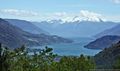
We started this season at Petrohue on the western end of Lago Todos los Santos. Access by bus to Petrohue is easy (Bus from Puerto Varas every 20 to 30 min). Petrohue is a suitable starting point for packrafters that travel southbound with heavier fjord-suitable packrafting equipment.
Lago Todos los Santos: can get very rough with wind but we had two calm days with moderate wind in the late afternoon only. We paddled 40 km in two easy days. Only few of the originally dozens of settlers are still living on the shore and mostly the rich and super-rich of Chile have build vacation homes on the often steep coastline. But since the access to lakes and lake shores is legally guaranteed in Chile, this should not cause a significant problem.
Rio Blanco: 6 years ago we met a settler from Rio Blanco who confirmed that a horse trail traverses this valley and connects to the Ruta de los Jesuitas (Paso Vuriloche). Now we came to investigate and record this route. The well maintained trail includes two river crossings that are well fordable in the morning after some reasonable dry days. Packrafters can cross these fords by packraft if the water level is elevated but hiker may struggle after heavy rain.
Ruta de los Jesuitas (Paso Vuriloche): A well maintained but muddy horse trail connects to Lago Cayetue. Three river generally easy river crossings may become difficult to pass after heavy rain.
Conclusion: Connecting from El Callao to Rio Blanco requires a shorter and more wind protected lake traverse (compared to the current regular route to Cayetue) making it an attractive option for packrafters and southbound hikers if the weather is reasonable dry. I’m considering to change the Regular Route for this option and recommend the route via Cayetue in bad weather only.
El Callao to Cayetue: 22 km on direct route El Callao to Rio Blanco: 14 km on direct route
Season 2020/21
Season 2019/20
- 2020-Jan-04 to 2020-Jan-06 / 3 days / hiking / SOBO / RR / Shaun
I accessed the southbound start of this section by walking 7km east from El Poncho on the dirt road that runs along the south shore of Lago Rupanco (=Oh-Mr-V@20-0a-#001). From settlers Sergio and Sandro, I learned that Esteban is an alternative to Rudy for crossing Lago Todos los Santos. Esteban was able to take me immediately, whereas around the same time Linda (see below) unfortunately had to wait a couple of days. My experience of the rest of section was similar to others’.
- 2020-Jan-03 to 2020-Jan-06 / 4 days / hiking / SOBO / RR / Linda
Starting on the beach of the North shore of Lago Rupanco (arriving from GPT20). Waypoint in Las Gaviotas Food and Lodging is great! Nelly prepared me a big glass of fresh raspberry juice.
Trail to Lago Todos Los Santos is easy and very nice. Only problem = the horse flies that loved me and I had at least 50 around me!
Stop at Las Termas! Beside the cold river, you will find a cabana with 2 bath tubes carved in wood full of hot thermal water. Amazing to camp and rest here.
Next house you will see on the trail is the one of Sergio. Very nice guy. He makes artisanal beer if you want to try one of them!
Then, as mentioned by Martin, in Refugio Dos cóndores, you can ask for the boat transfer of Lago Todos Los Santos to Rudy Jefi. 80000 CLP. I did and had to wait 2 days before crossing.
Other possibility for the boat transfer : when you arrive on the shore of Lago Todos Los Santos, ask the last house on the beach (waypoint = Settler) for Esteban. Same price 80000 CLP but you won't have necessarily to wait cause he seems to be more available than Rudy. Very nice man who offered me food and Lodging before I could cross the lake with Rudy! Say hello from me if you see him!!!
Between Lago Todos los Santos and Lago Cayutué, trail not maintained for about 2 kilometers. Easiest way to overcome the obstacles is to go on the left in the open fields and then go back on the track. Not that difficult but expect to be slow.
Then, after Lago Cayutué, no problem. Easy Hitchiki'g to Cochaml where you will find everything to resupply. Very good accommodation = Patagonia Nativa!
- 2019-DEC-23 to 2019-DEC-24 / 2 days / hiking / SOBO / RR / Martín Lizondo
Trail perfectly walkable. Ask Rudy Yefi in Dos Condores for boat transfer to Pto. Cayuthue (CLP 80.000). After crossing Lago de Todos los Santos the minor road finishes in a 1 km unmantained trail. After 1 km the trail becomes opened and it gets better as you aproach to Laguna Cayuthue. River crossings are easy, less than knee level. From Ralun there’s a bus stop to Cochamó or Pto. Montt.
- 2019-OCT-07 / hiking / Sophie & Hendrik
Refugio Las Termas is a great spot to camp out. Beside the cold river, the hot springs and the fire in the refugio are very nice after a hiking day.
- 2019-NOV-01 / hiking / Sophie & Hendrik
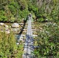
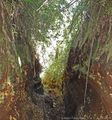
The part between Lago Cayutué and Lago Todo Los Santos is a bit tricky. The last winter(s?) damaged the trail a lot. Rivercrossings are up to knee deep and there is a lot of trees and debris on the trail. In wide parts it is easyer to walk to the right or left of it. Also at one point it is likely that you have to jump/crawl some barbed wire to get around some fallen trees. In some parts it is bush bashing. Expect to be slow in this part.
The river crossing south of Lago Cayutué is easier a little bit further south than indicated by the track files. There is a tree as a bridge.
- 2019-OCT-30 to 2019-NOV-04 / 6 days / hiking / NOBO / RR from one km east of Ralun / Sophie & Hendrik
First day we camped at Lago Cayutué. Second day (to Lago Todos Los Santos) we had bad weather and were a lot slower than expected. (The trail is very damaged in this part, see recent alerts.) Due to health issues we stoped here and went to Puerto Varas for some days. We reentered the trail and only looked for a goat free campsite on our first day back (some 50min of walking). The next stops before we made it to the end of the section were Refugio Las Termas (we highly recommend to take a bath here) and Laguna Los Quetros.
What we liked: Very nice woods, beautiful lakes, very friendly and sympathetic people, crossing Todos Los Santos in an open boat in very heavy rain was harsh but beautiful, the termas, funny animals on the way.
What we did not like so much: In very long parts extremely muddy (probably depends on the season), the trail conditions between Lago Cayutué and Lago Todos Los Santos (which forced us to crawl beneath barbed wire).
Season 2018/19
Season 2017/18
Season 2016/17
Resupply and Accommodation
Resupply and Accommodation in nearby Towns
- Shopping: Food
Cochamó: Possible to resupply out of the several small markets located here but expensive. Some restaurants and many housing options. Minimercado El Cruce at junction with the gravel road in Ralun, very basic. They have drinks, probably wine & possibly pasta. There is a kiosk in Las Gaviotas by the beach with basic snacks & drinks but its opening hours are irregular. On the road 1KM before Ralun NOBO there is a food truck but it only opens in the evenings after 5PM & may be closed in low season. There are no other resupply options along the road Cochamo-Ralun although there are cabanas about every 4KM, some may provide food if you stay there.
- Services: Laundry
A local woman offers a laundry service from her home a few houses down a side street from the main road in Cochamó.
Resupply and Accommodation along the Route
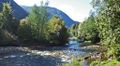
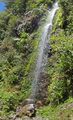
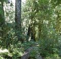
- There is nice camping at the small, scenic Laguna Los Quetros (Km6) near the northern start of the section. At the highly recommended Las Termas, around Km13, there is a small cabana with bath tubs carved of wood and full of hot thermal water. Settlers along the trail are interesting and welcoming.
- 2022 / Yannic & Mirjam
We took the bus from Puerto Montt to Osorono. Unfortunately, the morning bus to Lago Rupanco was already gone. There's supposed to be another one at 4:00 p.m. (...) We stopped at Rudy's and asked about the transport. Because of the increased gas prices, he wanted 140,000 CLP for the crossing, which was too expensive for us. We walked on to Esteban and were happy that he offered us the transfer for 80,000 CLP, which we accepted.
Transport to and from Route
- Southbound and northbound hiking is feasible and recommended. It may be easier to arrange a southbound than a northbound boat crossing of Lago Todos de Los Santos.
- 2023 / Martin & Helena
Another possible option for transfer over the lake - there should be boat called Elizabeth, organized by government for local residents, that leaves from the northern port km 29.9 on Friday at 9 AM. We don’t know about the other days. Rather verify with locals.
- 2022 / Alice & Florian
We took the bus from Ensenada to Petrohue (every 45 min each day).Then we arranged a boat transfer from Petrohue to Cayutue for 80 000 pesos. You can call Walter (+56999417795) to arrange in advance but we did not go through him in the end.
- Access to Start
Northbound: The bus leaves Puerto Montt main bus terminal (07:45, 12:00, 3:30PM & 5PM on weekdays, runs on weekends also but weekend schedule may differ) and travels via Puerto Varas, Ensenada & Ralun to Cochamó. Get off at Ralun crossroads (intersection with a small gravel road near Minimercado EL Cruce) if you don`t want to walk 15KM on the road from Cochamo to Ralun.
Southbound: Ferry Las Gaviotas-Puerto Buey Monday or Tuesday 7:00 & 16:30 Wednesday 2:30 PM, Friday 7:00 & 16:30, Sunday 15:00. Ferry connects with a bus. Buses may go to Entre Lagos, sometimes Puerto Octay or more often to Osorno. Buses every half hour Entre Lagos-Osorno. There should be an unscheduled ferry Las Gaviotas-Puerto Buey Monday or Tuesday, Wednesday, Friday & Sunday at 8PM but this ferry does not connect with a bus. Ferry Puerto Buey-Las Gaviotas Monday or Tuesday 8:00 & 17:30, Wednesday 15:30, Friday 8:00 & 17:30, Sunday 16:00. A bus coming from Osorno outside Terminal Rural goes to Puerto Buey to connect with the ferry on operational days, timetable not known. Ask at info. desk in Osorno Terminal Rural. No bus on days the ferry doesn`t run. Hitching is difficult, there is a gravel road all the way to Las Gaviotas but not much traffic except on weekends. In addition to accessing through GPT20, it is possible to take private transportation on the road that runs along the south shore of Lago Rupanco and walk the final 5-7km to the northern start point of GPT21.
- Return from Finish
Northbound: The ferry to Puerto Buey leaves right from the beach every day except Tuesday and Saturday, and costs 200 CLP as previously written. It leaves around 7-8 am and probably some other times as well, we took it Friday at 14 and we saw it leaving twice in the evening Thursday. The bus left from Puerto Buey (the shed where you get dropped of by the ferry) directly to Osorno at 15:30. We were told that the morning ferry matches a bus that only goes to Puerto Octay, but there are more busses from there.
Permits, Entry Fees and Right-of-Way Issues
Links to other Resources
Retired Section Article GPT21 - Lago Todos Los Santos
Images
[[Archivo: | ]]
| GPT21: Lago Todos Los Santos | Hiking | Packrafting | |||||
| Group | D: Lagos Chilenos | Total | 61.3 km | 19 h | 85.0 km | 26 h | |
| Region | Chile: Los Lagos (X) | Trails (TL) | 30.3 km | 49.4% | 26.9 km | 31.6% | |
| Start | Las Gaviotas | Minor Roads (MR) | 15.6 km | 25.4% | 16.0 km | 18.9% | |
| Finish | Cochamó | Primary Roads (PR) | 15.1 km | 24.7% | 2.0 km | 2.3% | |
| Status | Published & Verified | Cross-Country (CC) | 0.3 km | 0.5% | 0.8 km | 0.9% | |
| Traversable | Oct - Apr (Maybe: Sep, May) | Bush-Bashing (BB) | - | - | - | - | |
| Packraft | Very Useful | Ferry (FY) | (21.9 km) | (26.4%) | - | - | |
| Connects to | GPT20, GPT22 | Investigation (I) | - | - | - | - | |
| Options | 315 km (4 Options & Variants) | Exploration (EXP) | - | - | - | - | |
| Hiking | Packrafting | Total on Water | 39.4 km | 46.3% | |||
| Attraction | 3 (of 5) | 4 (of 5) | River (RI) | 2.8 km | 3.3% | ||
| Difficulty | 2 (of 5) | 4 (of 5) | Lake (LK) | 25.1 km | 29.6% | ||
| Direction | Both ↓↑ | Both ↓↑ | Fjord (FJ) | 11.4 km | 13.4% | ||
| Comment | - | ||||||
| Character | Valdivian Rain Forest, Summit Ascents, Hot Springs, Farmland, Settlers, Lake Packrafting, Fjord Packrafting | ||||||
| Challenges | - | ||||||


thumb|
thumb|
thumb|
thumb|
thumb|
thumb|


