![]()
Diferencia entre revisiones de «GPT07 - Laguna Dial»
(→Season Section Log) (Etiquetas: Edición desde móvil, Edición vía web móvil) |
(→Season Section Log) |
||
| Línea 35: | Línea 35: | ||
==Recent Alerts and Suggestions== | ==Recent Alerts and Suggestions== | ||
==Season Section Log== | ==Season Section Log== | ||
| + | *2019-Dec-18 / Lea Geibel & Kevin Moe / Optional/Exploration Route around Laguna del Maule / 4 days / | ||
| + | After finishing section 5 we only had 4 days left before the end of our hiking time, so we decided to do some exploring in the area instead of following the regular route of section 7. We followed the main road to the Laguna del Maule where we roughly went in a loop around the Laguna (~60km) starting at the Chilean Border Control. We checked in with the border control and informed them about our plans (that involved to not cross into Argentina but stay in Chile, just behind the Border Control). It was no problem for them, we just had to go through the Border Control again on our way back to have our backpacks checked for food. The water level of the laguna is very low and walking along the shore is mostly easy travel on sand/pumice, however, sometimes can be rather rocky and tedious. We climbed up some of the 3000 meter peaks around the Laguna (that mark the border with Argentina), each of them offering beautiful views on the area. There are several beautiful hidden lagunas higher up in glaciers that are well worth exploring. We never followed any particular route but just headed cross country to whichever place we fancied, which is very easy in the open, sandy terrain. The Southern end of the Laguna has many flamingos living in it, the East shore is mostly untouched by humans and the east side has some puestos and fishermen (mostly on weekends and close to the roads) but we didn't see anyone around. Around the Laguna there is a very strong thermal wind that picks up during the day but dies down/weakens a lot during the nights. | ||
| + | Highlights: all the views, swimming in laguna, lava fields flowing into the laguna, flamingos, numerous obsidian fields, empanadas de queso at the bistro right next to the border control (only open on weekends) | ||
| + | |||
*2019-Dec-24 / Martina & Ivo / Regular Route Southbound | *2019-Dec-24 / Martina & Ivo / Regular Route Southbound | ||
Revisión del 21:20 25 dic 2019


| All GPT sections (click to show) |
|---|
|
GPT Section Articles
|


Recent Alerts and Suggestions
Season Section Log
- 2019-Dec-18 / Lea Geibel & Kevin Moe / Optional/Exploration Route around Laguna del Maule / 4 days /
After finishing section 5 we only had 4 days left before the end of our hiking time, so we decided to do some exploring in the area instead of following the regular route of section 7. We followed the main road to the Laguna del Maule where we roughly went in a loop around the Laguna (~60km) starting at the Chilean Border Control. We checked in with the border control and informed them about our plans (that involved to not cross into Argentina but stay in Chile, just behind the Border Control). It was no problem for them, we just had to go through the Border Control again on our way back to have our backpacks checked for food. The water level of the laguna is very low and walking along the shore is mostly easy travel on sand/pumice, however, sometimes can be rather rocky and tedious. We climbed up some of the 3000 meter peaks around the Laguna (that mark the border with Argentina), each of them offering beautiful views on the area. There are several beautiful hidden lagunas higher up in glaciers that are well worth exploring. We never followed any particular route but just headed cross country to whichever place we fancied, which is very easy in the open, sandy terrain. The Southern end of the Laguna has many flamingos living in it, the East shore is mostly untouched by humans and the east side has some puestos and fishermen (mostly on weekends and close to the roads) but we didn't see anyone around. Around the Laguna there is a very strong thermal wind that picks up during the day but dies down/weakens a lot during the nights. Highlights: all the views, swimming in laguna, lava fields flowing into the laguna, flamingos, numerous obsidian fields, empanadas de queso at the bistro right next to the border control (only open on weekends)
- 2019-Dec-24 / Martina & Ivo / Regular Route Southbound
7 days for this awesome section. Absolutely agree with all of Matus & Anna's remarks :-) We went to San Fabian (excellent resupply place) for some days off.
- 2019-Dec-24 / Matus & Anna / Regular route SOBO
This section took us 5 days. Trail was in good conditon. River crossings were not a problem but plenty of water everywhere. In tienda in Carizales you can buy pasta, tuna, cola, beer some cookies. We bought huge chunk of cheese and some bread from Irma. It was amazing. Tienda in El Ingles is not best for resupply. We saw some tunas and pasta, but it was not enough for us to buy for next section. There is one more tienda down the road in Los Sauces but it was closed with no one around. We took bus to San Carlos which is leaving at 7am. We didn't find accomodation in El Ingles but it's possible to camp just before the bridge on the right side of the road.
Summary Table
| GPT07: Laguna Dial | Hiking | Packrafting | |||||
| Group | B: Zona Arrieros | Total | 155.5 km | 49 h | 153.3 km | 47 h | |
| Region | Chile: Maule (VII) & Bío Bío (VIII) | Trails (TL) | 126.9 km | 81.6% | 115.4 km | 75.3% | |
| Start | La Mina (Termas del Médano) | Minor Roads (MR) | 5.4 km | 3.5% | 5.4 km | 3.5% | |
| Finish | Puente Ingles | Primary Roads (PR) | 11.3 km | 7.3% | 11.3 km | 7.4% | |
| Status | Published & Verified | Cross-Country (CC) | 11.9 km | 7.7% | 12.2 km | 8.0% | |
| Traversable | Jan - Mar (Maybe: Dec, Apr) | Bush-Bashing (BB) | - | - | - | - | |
| Packraft | Deployable | Ferry (FY) | - | - | - | - | |
| Connects to | GPT06, GPT08 | Investigation (I) | - | - | - | - | |
| Options | 714 km (8 Options & Variants) | Exploration (EXP) | - | - | - | - | |
| Hiking | Packrafting | Total on Water | 9.0 km | 5.9% | |||
| Attraction | 4 (of 5) | 4 (of 5) | River (RI) | - | - | ||
| Difficulty | 3 (of 5) | 3 (of 5) | Lake (LK) | 9.0 km | 5.9% | ||
| Direction | Both ↓↑ | Both ↓↑ | Fjord (FJ) | - | - | ||
| Comment | - | ||||||
| Character | Forest, Alpine Terrain, Hot Springs, Mountain Pastures, Arrieros | ||||||
| Challenges | Demanding River Fords, Exposure to Elements, Resupply Distance | ||||||
Satellite Image Map
Elevation Profile

Section Planning Status
Recommended Travel Period
Benefits of Hiking and Packrafting
Recommended Travel Direction
Section Length and Travel Duration
Suitable Section Combinations
Section Attractiveness
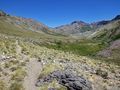
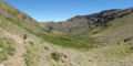
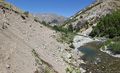
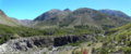
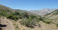
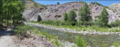
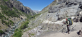
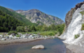
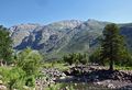
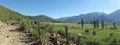
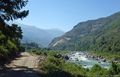
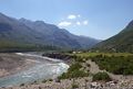
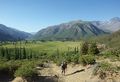
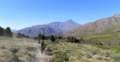
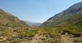
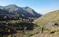
Thissection of the Greater Patagonian Trail leads in four to five hiking days through the wide open valley Melado to the crystal clear Laguna Dial. This lake was formed by a volcanic eruption that plugged the upper valley and transformed this part of the river into a long lake.
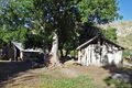
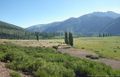
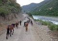
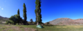
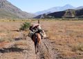
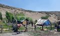
With the melting snow in spring and early summer herdsmen migrate up the valley with their animals. Occasional lush green patches intermigle with vegetation that struggles with the try soil. But the now visible life and the accompanying river Melado make a refreshing change after having crossed the death beauty of volcanic ash and lava in the week before on section 1. Don’t miss the puesto of Señora Irma, where you can eat fresh goat cheese with bread that was recently baked in the hot ash of a fire.
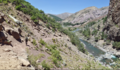
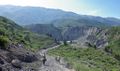
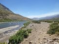
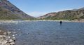
After having passed the deep blue Laguna Dial you descent through the now tighter but equally scenic valleys of the rivers Rió Rodriguez and Los Sauces to the small settlement Pichi Rincon and a place called El Ingles. Here you can take a bus to the small town San Fabian to take a rest and to resupply.
Section Difficulty
Resupply
Resupply Town
Shopping: Food
Shopping: Fuel
Shopping: Equipment
Services: Restaurants
Services: Laundry
Services: ATM and Money Exchange
Accommodation: Hostals and Hotels
Accommodation: Cabañas
Accommodation: Camping
Transport: Ground Transport
Transport: Ferries
Transport: Shipping Services
Resupply on the Trail
Location, Names, Available Items and Services
Access to Route and Return
Access to Start
Bus Talca - Termas El Medano
07:00 and 15:00
from Terminal Talca
Return from Finish
Escape Options
Permits, Entry Fees and Right-of-Way Issues
Regular Route
Regular Hiking Route
Regular Packrafting Route
Optional Routes
Investigations and Explorations
Links to other Resources
Alerts and Logs of Past Seasons
Images
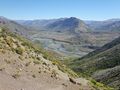
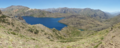
Laguna Dial
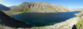
Laguna Dial