GPT17P - Neltume
Redirige a:
| All GPT sections (click to show) |
|---|
|
GPT Section Articles
|
Recent Alerts and Suggestions
Season Section Log
- January 3 / Zach / Southbound / 1 day
A peaceful paddle through the woods. There was one fallen tree across the river requiring easily lifting the boat over. The lago Neltume was very head windy in the afternoon so I walked the road but was quickly offered a ride to Ruta 203 where a bus soon passed.
- 2019-Dec-3 / Shaun C / 2 Days / Southbound / Regular Packrafting Route
Plenty of semi-submerged trees in the Rio Liquiñe/CuaCua, but the river is passable and relatively gentle throughout. The entrance to Lago Neltume from the river is beautiful. The hiking turn-off after Neltume at Km 35.7 seemed clear. There’s a wooden gate, then dirt roads. Also spent a few extra hours away from regular route exploring Op-Mr-V@17P-03 to see if there was a way across Rio ChanChan after previous destruction of the bridge. No luck. Seems bridge has not been replaced and in a definitely-not-thorough search, I didn’t find an easy alternative crossing point.
Summary Table
| GPT17P: Neltume | Hiking | Packrafting | |||||
| Group | D: Lagos Chilenos | Total | - | - | 39.6 km | 10 h | |
| Region | Chile: Los Ríos (XIV) | Trails (TL) | - | - | 0.7 km | 1.7% | |
| Start | Reyehueico | Minor Roads (MR) | - | - | 5.3 km | 13.2% | |
| Finish | Puerto Fuy | Primary Roads (PR) | - | - | 9.4 km | 23.7% | |
| Status | Published & Verified | Cross-Country (CC) | - | - | 0.3 km | 0.6% | |
| Traversable | Nov - May (Maybe: Sep, Oct) | Bush-Bashing (BB) | - | - | - | - | |
| Packraft | Required | Ferry (FY) | - | - | - | - | |
| Connects to | GPT16, GPT17H, GPT18 | Investigation (I) | - | - | (1.8 km) | (4.6%) | |
| Options | 169 km (3 Options & Variants) | Exploration (EXP) | - | - | - | - | |
| Hiking | Packrafting | Total on Water | 24.1 km | 60.7% | |||
| Attraction | - | 4 (of 5) | River (RI) | 20.4 km | 51.5% | ||
| Difficulty | - | 3 (of 5) | Lake (LK) | 3.6 km | 9.2% | ||
| Direction | None | Only ↓ | Fjord (FJ) | - | - | ||
| Comment | Hiking: Hiking not feasible | ||||||
| Character | Valdivian Rain Forest, Farmland, Pehuenche, River Packrafting, Lake Packrafting | ||||||
| Challenges | - | ||||||
Satellite Image Map
Elevation Profile
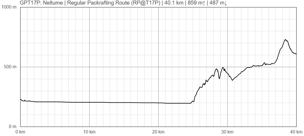
Elevation Profile of Regular Packrafting Route
Section Planning Status
Recommended Travel Period
The packrafting Route is best paddled between November and May.
Benefits of Hiking and Packrafting
Recommended Travel Direction
Río Liquiñe can only be paddled southbound. Lago Neltume and the hiking portion of the section can be done in either direction.
Section Length and Travel Duration
The 40km of this section (25km paddling, 15km hiking) can be completed in about a day and a half.
Suitable Section Combinations
Section Attractiveness
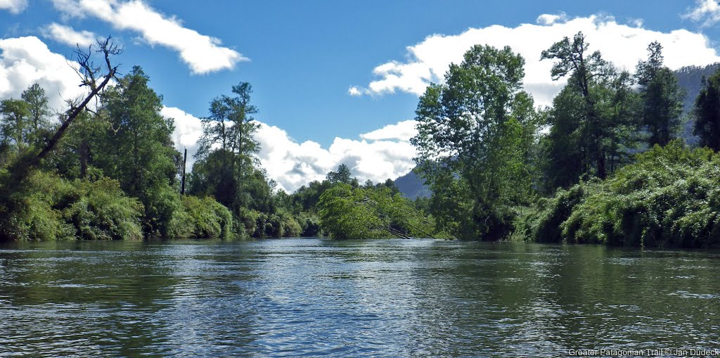
Río Liquiñe is pretty with few signs of other people, and it has a number of good camping spots. The entrance into Lago Neltume is beautiful, as is the lake itself. The hiking segments are not especially attractive, but Lago Pirihueico at the end of the section is stunning as either a separate add-on packraft, or ferry ride.
Section Difficulty
There are only a couple of early minor rapids on this part of Rio Liquiñe and it is generally gentle throughout, running at 4-5kmph initially, and 2kmph towards the end. There are, however, many trees in the river, sometimes entirely across it. At low water levels it can be necessary to porter around these, even involving some bush-bashing. But at other times, paddlers have been able to pass without trouble.
Resupply
Resupply Town
Puerto Fuy has a few restaurants and food shops.
Shopping: Food
Shopping: Fuel
Shopping: Equipment
Services: Restaurants
Services: Laundry
Services: ATM and Money Exchange
Accommodation: Hostals and Hotels
Accommodation: Cabañas
Accommodation: Camping
Transport: Ground Transport
Regular buses run from Puerto Fuy.
Transport: Ferries
A car and passenger ferry runs the length of Lago Pirihueico several times a day from Puerto Fuy to the south-eastern end of the lake.
Transport: Shipping Services
Resupply on the Trail
Location, Names, Available Items and Services
Access to Route and Return
Access to Start
Return from Finish
Escape Options
Permits, Entry Fees and Right-of-Way Issues
Regular Route
Regular Hiking Route
Previously, the hiking segment went east from Lago Neltume and crossed Rio ChanChan then continued to Puerto Fuy. However, the bridge crossing that river has since been destroyed. So, in the absence of a clear and safe alternative crossing option, the route now follows primary roads for 9km until a turn-off onto more interesting dirt roads at Km35.7.
Regular Packrafting Route
- Route description by Kara Davis after Season 2017/18:
The GPT does not go through Carriringue, but if you do decide to go into town the route is easy to rejoin by walking south along the paved road, T-29, to Río Liquiñe. There is an established campsite (5.000 CLP/night) which is part of the Red de Turismo Rural where the paved road crosses the river. This campsite has flush toilets, cold showers, and trash. The Río Liquiñe is windy and narrow. Pay attention to the several semi-submerged fallen trees that litter the river. The packrafting portion of this section ends with a 4 km paddle along the eastern shore of Lago Neltume. There’s easy access to the road, T-29, the entire time, but camping is improbable due to the abundance of private property. At the end of the lake paddle, there is an established campsite (5.000 CLP/night). This site has flush toilets and trash. Alternate Route: At this point, the recommended packrafting route turns off T-29 onto a gravel road. DO NOT TAKE THIS ROUTE. It eventually leads to a river that is now impassible due to a destroyed bridge. An alternative is to continue along T-29 until reaching the highway, 203-CH. Follow this highway through Neltume all the way to Puerto Fuy. Although the recommended packrafting route turns off of the highway after Neltume, on the ground it was unclear where this turnoff was. We decided to road walk all the way to Puerto Fuy. Comment by Jan Dudeck: Last season and this season 3 hikers/couples attempted to follow this route (RP-MR-V@17P-25.1). Two turned back, one made it over the river mentioned by Kara above. So the safest option is currently not take regular route (track RP-MR-V@17P-25.1) but stay on the main road taking Variant “H” (track OP-PR-V@17P-H-#). Town: Neltume/Puerto Fuy to Panguipulli Neltume has options for lodging, a few restaurants, and a bus to Panguipulli—the closest large town for resupply. Ask a local for directions to the bus stop and about arrival times. At Puerto Fuy, there were several signs advertising lodging. However, it would be difficult to resupply here. Comment by Jan Dudeck: I recall about half a dozen mini shops in Puerto Fuy that are sometimes hidden in the side roads. But its a best practice to resupply in the first bigger shop you find on the route (i.e. Neltume) and try in the next village to purchase what you did not get in the first place (i.e. Puerto Fuy).


