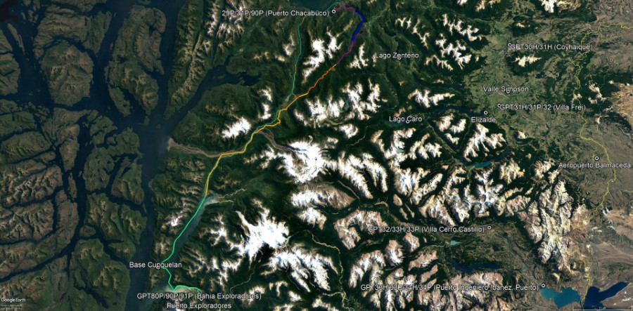
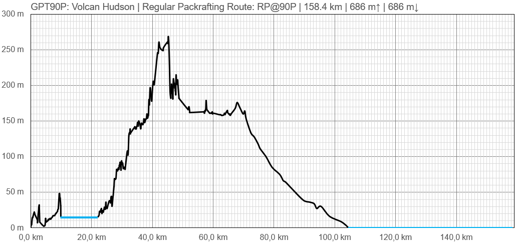
GPT90P - Volcán Hudson
| All GPT sections (click to show) |
|---|
|
GPT Section Articles
|
Recent Alerts and Suggestions
Season Section Log
- GPT90 / Regular Route Southbound Exploration Attempt (Lago Riesco, Rio Condor, Laguna del Paso) / 2019-Nov-30 / Not Traversable
We investigate with Tobias Hellwig the Route from Lago Riesco towards Rio Huemules from where packrafters can continue on fjords to Bahia Exploradores. To both of us this seamed a virtually unknown but spectacular route if Rio Huemules can be reached walking.
Satellite images show at least 3 tiny settlements in the wi de open valleys west of vulcano Hudson but we had no clear information if all settlers have abandoned this area or not therefore we started from the north which is the shorter end to the “bottleneck” of this traverse.
A well maintained gravel road with two recently build bridges end approximately 12 km south of Lago Riesco in the valley of Rio San Sebastián. From this point continues a very muddy road that gradually degrades into a very muddy trail.
On the way we spoke to the last settler on this route - Don Julian - who stated that this route was the last time traversed around 3 years ago (around 2016) and that the trail was partially cleaned a few months ago (June 2019). From this conversation it remained unclear if a traverse is still possible or not.
Therefore we investigated this route first without backpacks. Tobias and I had an estimate track because parts of this route are well visible on satellite images. On the first afternoon we followed the recently cleaned trail for about 5 km. The entire trail was easy to spot, only the countless mud holes slowed the advance. The trail showed that a significant effort was made when building it; the trail was wide, muddy sections were filled with wood and bridges were build over small streams.
This trail condition nurtured our hope that at least the first wide open valley can be reached on this trail so we packed our heavy backpacks to make an attempt.
The positive mood and the discussion how to best traverse the wide open valleys ahead of us instantly stopped after around 10 km when we reached the end of the recently cleaned trail section. A wall of Quila (a kind bamboo grass) suddenly blocked the trail and satellite images showed a similar landscape on the following 3 km. Quila grows very quickly in open areas and forms an impenetrable red of up to 5 meter high sticks. Under the Quila the old trail was still perfectly well visible but just with the use of a machete (and not a chainsaw) it seamed impossible to open 3 km of badly overgrown trail. So we turned around stumbling back through the chain of mud holes.
This and other similar experiences led me to the following conclusions:
1. The GPT is not a wilderness trail but a route network on the borderline of human advanced into the wilderness of the Andes. Wherever the people leave, the nature reclaims the land and the traces of human settlements disappear over time. Without the arrieros in the north, the Pehuenche in the Araucania and the colonos in the South the trails cease to exits and with this the GPT disappears. Experiencing less interventioned terrain in Patagonia is limited to: - the areas above the tree-line - the more open Pampa on the Argentine side - or on water by packraft or kayak (rivers, lakes, fjords). Everywhere else visitors rely on the people that party transformed the wilderness in search of making a living.
2. In the costal area of the Aysen region settlers are on the retreat. Satellite images still show a good number of roofs and former pastures of abandoned settlements but the trails to these settlements can become impassable after just one or two years without use, especially where the intentional fires set by the first settlers destroyed the original forest.
3. In the last week we investigated both possible northern entry routes of section GPT90 from Puerto Aysen towards Bahia Erasmus and in both cases we arrived a few years late. The route via Lago Condor is abandoned since around 2013 and the route via Lago Riesco since around 2016. It remains doubtful if one of two route might be (temporary) opened again.
4. When hiking in the Aysen region take with you and deploy a machete to contribute your part to trail maintenance.
- GPT90P Investigation of Option 1 from Puerto Aysen to Lago Condor / 2019-Nov-27 / 2 days / Meylin Ubilla & Jan Dudeck
10 years ago it would have been an uncomplicated packraft-hiking-traverse to get from Puerto Aysen to the barely known Lago Condor. At this time settlers lived on this lake and a power-utility-company performed a research for a hydro-power-project. The hydro-power-project was cancelled off; the settlers left their property and visited it for the last time around 2013 and since then humans left this place for good.
Now in 2019 it requires probably a 2-day machete fight to cover the roughly 5 km on a now completely overgrown and muddy former trail from the closest river landing beach.
This transformation is visible to a careful observers on satellite images. When scrolling through the different images of this area trails and research sites are clearly noticeable around 2011 but these signs of human intervention disappear on images from 2016 and later.
To our surprise we meet the last settler in this area; Don Jose Vera; in a Puesto a few hundred meters up the river from the fjord. He provided us with the above information that confirmed our analysis of satellite images and other publicly available information.
Due to a other plans, a different more promising route and unsuitable weather we returned to Puerto Chacabuco after meeting and speaking with Don Jose Vera.
In the coming week we will investigate another more promising route into these hidden valleys and if successful then adventurous packrafters might become the first visitors of Lago Condor in years by combining two routes into a circuit.
Anyone interested to rediscover the route to Lago Condor, Lago Claro and Lago Ellis should:
1. Paddle on a calm day from Puerto Aysen or Puerto Chacabuco to the mouth of the river that drains Lago Condor.
2. Attempt to paddle 2.5 km on this river against the flow to an open area (“pampita”). This is best done on high tide. If this is not possible then get at least to the Puesto of Don Jose Vera and follow the trail next to the river to this open area (reasonable well maintained but muddy). Locals occasionally visit this place by motor boat to collect fire wood.
3. Build your camp in this open area and search and re-open the old trail to Lago Condor. This will take at least one day but best plan two full days.
4. Cross the 14 km long Lago Condor.
5. Traverse the 3 km from Lago Condor to Lago Claro on land. You will pass an abandoned settlement area.
6. Cross the 5 km long Laguna Claro.
7. Traverse the 2 km from Laguna Claro to Lago Ellis possibly following the river.
8. If confirmed in the next week return on a still maintained trail from Lago Ellis to Lago Riesco from where you can packraft on Rio Blanco back to Puerto Aysen.
This traverse is best attempted in January, February or March after a relative dry period.
The first documented traverse of this route was done around 1947 by Agusto Grosse with much inferior gear. So, should you make it there is no reason to feel heroic but recognize the achievement of the people that had been there before.
Summary Table
| GPT90P: Volcán Hudson | Hiking | Packrafting | |||||
| Group | P: Fiordos Sur | Total | - | - | 158.4 km | 42 h | |
| Region | Chile: Aysén (XI) | Trails (TL) | - | - | 25.7 km | 16.2% | |
| Start | Puerto Chacabuco | Minor Roads (MR) | - | - | 13.6 km | 8.6% | |
| Finish | Bahia Exploradores | Primary Roads (PR) | - | - | 4.2 km | 2.7% | |
| Status | To be Verified & Recorded by GPS | Cross-Country (CC) | - | - | 47.9 km | 30.3% | |
| Traversable | Jan - Mar (Maybe: Nov, Dec, Apr, May) | Bush-Bashing (BB) | - | - | - | - | |
| Packraft | Required | Ferry (FY) | - | - | - | - | |
| Connects to | GPT29P, GPT31P, GPT80P, GPT91P | Investigation (I) | - | - | (9.5 km) | (6.0%) | |
| Options | 116 km (2 Options & Variants) | Exploration (EXP) | - | - | (125.9 km) | (79.5%) | |
| Hiking | Packrafting | Total on Water | 66.9 km | 42.2% | |||
| Attraction | - | 4 (of 5) | River (RI) | 7.5 km | 4.7% | ||
| Difficulty | - | 6 (of 5) | Lake (LK) | 12.1 km | 7.6% | ||
| Direction | None | Only ↓ | Fjord (FJ) | 47.3 km | 29.9% | ||
| Comment | Hiking: Hiking not feasible | ||||||
| Character | Valdivian Rain Forest, Volcanic Terrain, Sea Coast, Unpeopled Areas, Fjord Packrafting | ||||||
| Challenges | Demanding River Fords, Bush Bashing, Demanding Navigation, Resupply Distance, Possibly Impassable, Exploration Required | ||||||


