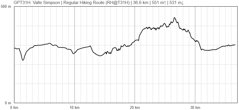
GPT31H (Valle Simpson)
Add a new log entry always on top in the appropriate season sub-chapter and use format:
* Start Date to Finish Date (use Format YYYY-MMM-DD) / Duration in Days / Hiking or Packrafting / Travel Direction (SOBO for Southbound or NOBO Northbound) / Chosen Route and/or Option Name (RR for Regular Route) / Names or Alias
Summary with remarks to route that are considered useful for other hikers and packrafters. Include alerts, suggestions and personal perception of attractiveness and difficulties.
Add a sub-chapter by placing two "=" before and after the new sub-chapter heading ('==Sub-Chapter Heading==').
Contenido
Section Log, Alerts and Suggestions
Season 2025/26
Season 2024/25
Season 2023/24
Season 2022/23
- 03-Apr-2023 / Hiking / NOBO / Martin & Helena
Easy section that connects Coyhaique and Villa Frei. Minor road will take you around few lakes and local settlements, which makes some nice sceneries with surrounding mountains. They were partly covered with fresh snow in our case. Taking a bus from Coyhaique terminal to Villa Frei in the morning, we started quite early for our standards, and therefore we made it easily in 1 day, coming back to Coyhaique in the late afternoon. Because of a light rain, the road was not that dusty, but it might be annoying in dry weather, especially the last part around airport, that was also quite busy.
Contact: @martin_hanzelka @helenneka
Season 2021/22
Season 2020/21
Season 2019/20
Season 2018/19
Season 2017/18
Season 2016/17
Resupply and Accommodation
Resupply and Accommodation in nearby Towns
Resupply and Accommodation along the Route
Transport to and from Route
Permits, Entry Fees and Right-of-Way Issues
Links to other Resources
Retired Section Article GPT31H - Valle Simpson
Images
[[Archivo: | ]]
| GPT31H: Valle Simpson | Hiking | Packrafting | |||||
| Group | G: Aysen Norte | Total | 36.6 km | 9 h | - | - | |
| Region | Chile: Aysén (XI) | Trails (TL) | - | - | - | - | |
| Start | Coyhaique | Minor Roads (MR) | 20.7 km | 56.6% | - | - | |
| Finish | Villa Frei | Primary Roads (PR) | 15.9 km | 43.4% | - | - | |
| Status | Published & Verified | Cross-Country (CC) | - | - | - | - | |
| Traversable | Sep - May | Bush-Bashing (BB) | - | - | - | - | |
| Packraft | Only Burden | Ferry (FY) | - | - | - | - | |
| Connects to | GPT30H, GPT32 | Investigation (I) | - | - | - | - | |
| Options | 8 km (Variants Only) | Exploration (EXP) | - | - | - | - | |
| Hiking | Packrafting | Total on Water | - | - | |||
| Attraction | 1 (of 5) | - | River (RI) | - | - | ||
| Difficulty | 1 (of 5) | - | Lake (LK) | - | - | ||
| Direction | Both ↓↑ | - | Fjord (FJ) | - | - | ||
| Comment | - | ||||||
| Character | Farmland, Settlers, Road Walking | ||||||
| Challenges | - | ||||||

