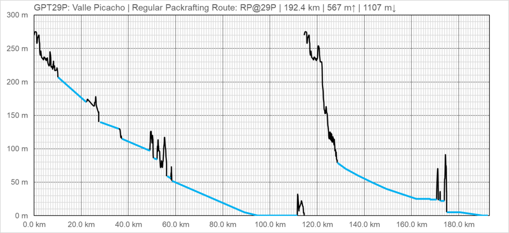
GPT29P (Valle Picacho)
Add a new log entry always on top in the appropriate season sub-chapter and use format:
* Start Date to Finish Date (use Format YYYY-MMM-DD) / Duration in Days / Hiking or Packrafting / Travel Direction (SOBO for Southbound or NOBO Northbound) / Chosen Route and/or Option Name (RR for Regular Route) / Names or Alias
Summary with remarks to route that are considered useful for other hikers and packrafters. Include alerts, suggestions and personal perception of attractiveness and difficulties.
Add a sub-chapter by placing two "=" before and after the new sub-chapter heading ('==Sub-Chapter Heading==').
Contenido
Section Log, Alerts and Suggestions
Season 2025/26
Season 2024/25
Season 2023/24
Season 2022/23
Season 2021/22
- 2022-Jan-04 to 2022-Jan-06 / Tobias Schorcht / Northbound / Regular Packrafting Route from Picaflor to Puerto Cisnes / 2.5 days
Exploring this Remote Valley was one of my favourite parts of the southern GPT. Since there were some days with heavy rain before I went, water levels were high. Many rapids class 2 let me enjoy the Rio Picacho a lot. Such a wild and mystic place! The first rapid of Lago Copa could be packrafted as well, the 3 other rapids I needed to bypass, which was VERY challenging, because I didn‘t bring a machete (stupid me). It took me 4 hours to bypass the second rapid of Lago copa (only 2,5 Kilometers!). Don’t ask how I managed to get through that dense Jungle, but there was also no way back. I looked very funny afterwards. The third Rapid on Lago copa is „easy“ to Bypass. Thanks to Tobias Hellwig, Ricardo Campos , Jen Ni and Meylin Elisabeth Ubilla González for cleaning up the last bypass from Lago Copa to Lago Escondido in 2019!! The Trail is still visible, only some parts are overgrown. I highly recommend to read there well written and detailed Report below.
Season 2020/21
Season 2019/20
Season 2018/19
Season 2017/18
Season 2016/17
Resupply and Accommodation
Resupply and Accommodation in nearby Towns
Resupply and Accommodation along the Route
Transport to and from Route
Permits, Entry Fees and Right-of-Way Issues
Links to other Resources
Retired Section Article GPT29P - Valle Picacho
Images
[[Archivo: | ]]
| GPT29P: Valle Picacho | Hiking | Packrafting | |||||
| Group | G: Aysen Norte | Total | - | - | 192.4 km | 44 h | |
| Region | Chile: Aysén (XI) | Trails (TL) | - | - | 0.7 km | 0.40% | |
| Start | Carretera Austral (Camino Picaflor) | Minor Roads (MR) | - | - | 24.0 km | 12.50% | |
| Finish | Puerto Cisnes, Puerto Cisnes | Primary Roads (PR) | - | - | 12.7 km | 6.60% | |
| Status | Published & Verified | Cross-Country (CC) | - | - | 3.9 km | 2.00% | |
| Traversable | Jan - Apr (Maybe: Dec, May) | Bush-Bashing (BB) | - | - | 1.3 km | 0.70% | |
| Packraft | Required | Ferry (FY) | - | - | - | - | |
| Connects to | GPT28P, GPT29H, GPT30H, GPT30P, GPT31P | Investigation (I) | - | - | - | - | |
| Options | 263 km (3 Options & Variants) | Exploration (EXP) | - | - | (39.9 km) | (20.7%) | |
| Hiking | Packrafting | Total on Water | 149.7 km | 77.8% | |||
| Attraction | - | 5 (of 5) | River (RI) | 127.2 km | 66.1% | ||
| Difficulty | - | 6 (of 5) | Lake (LK) | 16.3 km | 8.5% | ||
| Direction | None | Only ↑ | Fjord (FJ) | 6.1 km | 3.2% | ||
| Comment | Hiking: Hiking not feasible | ||||||
| Character | Packrafting: Flip-Flop recommended | ||||||
| Challenges | Valdivian Rain Forest, Sea Coast, Farmland, Settlers, Unpeopled Areas, River Packrafting, Lake Packrafting, Fjord Packrafting | ||||||

