Diferencia entre revisiones de «GPT11 - Cerro Moncol»
(→Season Section Log) |
(→Season Section Log) (Etiquetas: Edición desde móvil, Edición vía web móvil) |
||
| Línea 33: | Línea 33: | ||
==Season Section Log== | ==Season Section Log== | ||
| + | * 9-Jan-2020 / Matus & Anna | ||
| + | We combined sections 11 and 12. It took us 5 days including one zero because of weather. Patagonia showed us bit of it's potential in these two sections. | ||
| + | All walked trails were in good condition and CC sections pretty easy to navigate. In the sadle of section 11, because of strong wind, poor visibility and fresh snow and ice we were forced to take optional to the valley. There is a big snowfield, I don't recomend sliding on it all the way. It the lower parts there were big holes into the stream. | ||
| + | From Ranquil we took optional #002 because we didn't want to climb back up. Uphill is more a minor road, downhill nice trail. | ||
| + | After a laguna we took a optional to the Pass 2180 and road around the Pehuenche Extortioner. We needed to get down from elevation ASAP bacause of wind. We passed puesto early in the morning and no one was around. After rainy day everything above 2000m was white. We took trail to pass 1920m which was just with bit of fresh snow and then took minor road #001 down to valley. So I have no idea about the rest of the trail. | ||
| + | Edit: adding a picture from the last sadle 1920m, we did after "rainy" day. | ||
Linda | Linda | ||
Revisión del 19:03 15 ene 2020
| All GPT sections (click to show) |
|---|
|
GPT Section Articles
|
Recent Alerts and Suggestions
- 11.12.2019 Sophie & Hendrik
Snow on top of Cerro Moncol made the regular route more difficult.
Season Section Log
- 9-Jan-2020 / Matus & Anna
We combined sections 11 and 12. It took us 5 days including one zero because of weather. Patagonia showed us bit of it's potential in these two sections. All walked trails were in good condition and CC sections pretty easy to navigate. In the sadle of section 11, because of strong wind, poor visibility and fresh snow and ice we were forced to take optional to the valley. There is a big snowfield, I don't recomend sliding on it all the way. It the lower parts there were big holes into the stream. From Ranquil we took optional #002 because we didn't want to climb back up. Uphill is more a minor road, downhill nice trail. After a laguna we took a optional to the Pass 2180 and road around the Pehuenche Extortioner. We needed to get down from elevation ASAP bacause of wind. We passed puesto early in the morning and no one was around. After rainy day everything above 2000m was white. We took trail to pass 1920m which was just with bit of fresh snow and then took minor road #001 down to valley. So I have no idea about the rest of the trail. Edit: adding a picture from the last sadle 1920m, we did after "rainy" day.
Linda 27/12/2019 - 28/12/2019 2 days Southbound Regular hiking route until the pass 2180 meters and then Option 3
Nice section ! After the pass, I decided to go down along Option 3 that goes into the canyon. Lot of snow at the beginning, but that was fun cause the slope was not very steep and I could use my bag raincover as a sledge to go down!
Then, I ended up into the canyon, crossing the river at least 20 times but no problem cause the water level is low and the river is tight (compared to GPT07 for instance).
The only difficulty was once the canyon becomes too tight and I had to find a way up and had to face a landslide. Just one part of 5 meters wide but quite dangerous cause very sleepy with the rocks falling down.
After, back into the canyon until I could join the Regular Hiking route. No difficulties until Ranquil.
Was lucky to find people with a car who dropped me in Lonquimai cause I had to resupply. Otherwise, only 3 Buses a week from Ranquil (no tiendas to resupply) to Lonquimai = Monday, Wednesday, Friday
Supermercado with everything to resupply and accommodations in Lonquimai
- 12.12.19 / Sophie & Hendrik / 4.5 days (19 walking hours) / Northbound / Regular Hiking Route.
In total we were 5.5 days on the trail, of which we spend 1 in the tent due to bad weather. On Cerro Moncol there was still some snow, which made us very slow, as we either had the options to walk on steep snow or walk higher up in more difficult terrain. Rivercrossings were no problem.
We liked: The amazing views, the condors we met at the northern part of the pass (they came very close to us), the mountain crystals of which there are plenty on the northern side of Cerro Moncol.
We did not like so much: The higher difficulty due to the snow in some parts.
Summary Table
| GPT11: Cerro Moncol | Hiking | Packrafting | |||||
| Group | C: Zona Pehuenche | Total | 40.5 km | 15 h | - | - | |
| Region | Chile: Bío Bío (VIII) & Araucanía (IX) | Trails (TL) | 29.0 km | 71.6% | - | - | |
| Start | Guallali (Carabiñeros) | Minor Roads (MR) | 5.8 km | 14.2% | - | - | |
| Finish | Ranquil (Carabiñeros) | Primary Roads (PR) | - | - | - | - | |
| Status | Published & Verified | Cross-Country (CC) | 5.7 km | 14.2% | - | - | |
| Traversable | Dec - Mar (Maybe: Nov, Apr) | Bush-Bashing (BB) | - | - | - | - | |
| Packraft | Only Burden | Ferry (FY) | - | - | - | - | |
| Connects to | GPT10, GPT12 | Investigation (I) | - | - | - | - | |
| Options | 313 km (5 Options & Variants) | Exploration (EXP) | - | - | - | - | |
| Hiking | Packrafting | Total on Water | - | - | |||
| Attraction | 5 (of 5) | - | River (RI) | - | - | ||
| Difficulty | 4 (of 5) | - | Lake (LK) | - | - | ||
| Direction | Both ↓↑ | - | Fjord (FJ) | - | - | ||
| Comment | - | ||||||
| Character | Araucaria Forest, Alpine Terrain, Summit Ascents, Hot Springs, Mountain Pastures, Pehuenche | ||||||
| Challenges | Exposure to Elements, Clambering, Demanding Navigation | ||||||
Satellite Image Map
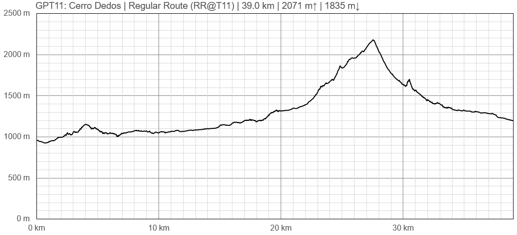
Elevation Profile
Elevation Profile of Regular Hiking Route
Comments to Regular Hiking Route
Elevation Profile of Regular Packrafting Route
[[File:|frame|center|Elevation Profile of Regular Hiking Route (2019)]]


