Diferencia entre revisiones de «GPT33H (Torres de Avellano)»
(→Images) |
(→Season 2022/23) |
||
| Línea 23: | Línea 23: | ||
==Season 2022/23== | ==Season 2022/23== | ||
| + | |||
| + | *2023-Mar-30 to 2023-Mar-31 / 1.5 days / Hiking / SOBO / RR + Option 1 / Martin & Helena | ||
| + | |||
| + | We started from Villa Cerro Castillo around 11 AM and took ferry from the port the next day at noon. The former RR trail follows path of Sendero de Chile, and starting with no expectations we were quite impressed with what it offers, especially all the amazing views of Cerro Castillo. It's definitely a good short alternative to the Torres del Avellano detour that we were forced to skip. Trail is easy to follow and you can find many camp spots along the way. There are many small shops in Puerto Ibáñez. Knowing the ferry schedule we went directly to the port where were just a few others in this time of the year. | ||
| + | |||
| + | Contact: @martin_hanzelka @helenneka | ||
==Season 2021/22== | ==Season 2021/22== | ||
Revisión del 19:41 12 sep 2023
Add a new log entry always on top in the appropriate season sub-chapter and use format:
* Start Date to Finish Date (use Format YYYY-MMM-DD) / Duration in Days / Hiking or Packrafting / Travel Direction (SOBO for Southbound or NOBO Northbound) / Chosen Route and/or Option Name (RR for Regular Route) / Names or Alias
Summary with remarks to route that are considered useful for other hikers and packrafters. Include alerts, suggestions and personal perception of attractiveness and difficulties.
Add a sub-chapter by placing two "=" before and after the new sub-chapter heading ('==Sub-Chapter Heading==').
Contenido
Section Log, Alerts and Suggestions
Season 2025/26
Season 2024/25
Season 2023/24
Season 2022/23
- 2023-Mar-30 to 2023-Mar-31 / 1.5 days / Hiking / SOBO / RR + Option 1 / Martin & Helena
We started from Villa Cerro Castillo around 11 AM and took ferry from the port the next day at noon. The former RR trail follows path of Sendero de Chile, and starting with no expectations we were quite impressed with what it offers, especially all the amazing views of Cerro Castillo. It's definitely a good short alternative to the Torres del Avellano detour that we were forced to skip. Trail is easy to follow and you can find many camp spots along the way. There are many small shops in Puerto Ibáñez. Knowing the ferry schedule we went directly to the port where were just a few others in this time of the year.
Contact: @martin_hanzelka @helenneka
Season 2021/22
Season 2020/21
Season 2019/20
Season 2018/19
Season 2017/18
Season 2016/17
Resupply and Accommodation
Resupply and Accommodation in nearby Towns
Resupply and Accommodation along the Route
Transport to and from Route
Permits, Entry Fees and Right-of-Way Issues
Links to other Resources
Retired Section Article GPT33H - Puerto Ibañez
Retired Section Article GPT33H - Torres del Avellano
Images
[[Archivo: | ]]
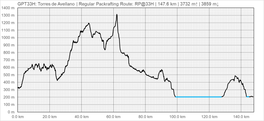
| GPT33H: Torres de Avellano | Hiking | Packrafting | |||||
| Group | H: Aysen Sur | Total | 157.0 km | 49 h | 147.6 km | 44 h | |
| Region | Chile: Aysén (XI) | Trails (TL) | 45.6 km | 29.10% | 25.9 km | 17.60% | |
| Start | Villa Cerro Castillo | Minor Roads (MR) | 93.0 km | 59.20% | 73.3 km | 49.70% | |
| Finish | Puerto Ingeniero Ibañez (Puerto) | Primary Roads (PR) | 3.7 km | 2.30% | 2.3 km | 1.60% | |
| Status | Published & Verified | Cross-Country (CC) | 14.3 km | 9.10% | 15.1 km | 10.20% | |
| Traversable | Dec - Mar (Maybe: Nov, Apr) | Bush-Bashing (BB) | 0.4 km | 0.20% | 0.4 km | 0.30% | |
| Packraft | Deployable | Ferry (FY) | - | - | - | - | |
| Connects to | GPT32, GPT33P, GPT34H, GPT34P | Investigation (I) | (5.2 km) | (3.3%) | - | - | |
| Options | 382 km (9 Options & Variants) | Exploration (EXP) | - | - | - | - | |
| Hiking | Packrafting | Total on Water | 30.5 km | 20.7% | |||
| Attraction | 5 (of 5) | 5 (of 5) | River (RI) | 1.7 km | 1.2% | ||
| Difficulty | 5 (of 5) | 5 (of 5) | Lake (LK) | 28.8 km | 19.5% | ||
| Direction | Both ↓↑ | Both ↓↑ | Fjord (FJ) | - | - | ||
| Comment | - | ||||||
| Character | Semi-Desert, Forest, Alpine Terrain, Glaciers, Mountain Pastures, Farmland, Settlers, River Packrafting, Lake Packrafting, Road Walking | ||||||
| Challenges | Demanding River Fords, Exposure to Elements, Clambering, Bush Bashing, Demanding Navigation, Resupply Distance, Possibly Impassable | ||||||


