|
|
| Línea 24: |
Línea 24: |
| | {{GPT KMZ}} | | {{GPT KMZ}} |
| | }} | | }} |
| | + | {{Table all GPTs}} |
| | ==Section Statistics== | | ==Section Statistics== |
| | ==Basic statistics== | | ==Basic statistics== |
Revisión del 13:17 28 mar 2019
This article is just a draft. You can help by expanding and improving its content
|
|
|
| Summary (editar)
|
| Activity
|
Trekking
|
| Location
|
Chile, Chillán
|
|
|
| Atractions
|
Vistas panorámicas
|
| Duration
|
días "Días" no está en la lista de valores posibles (3 horas o menos, 1/2 día, 3/4 día, 1 día, 1 día y medio, 2 días, 3 días, 4 días, 5 días, 3 - 5 días, 6 - 7 días, 8 - 10 días, 11 - 14 días, 15 - 20 días, 20 - 25 días, 26 - 35 días, 36 - 60 días, 61 - 89 días, más de 90 días) para esta propiedad.
|
|
|
| Trail
|
Siempre Claro
|
| Signage
|
Inexistente
|
| Infraestructure
|
Inexistente
|
|
|
|
|
| Topology
|
Cruce
|
| Gain/Loss (meters)
|
+6636, -6544
|
| Distance (k)
|
14.1
|
|
|
| Skills
|
No requiere
|
| Original creator
|
Jan Dudeck
|
| Download KMZ/GPX
|
Debes registrarte para descargar. Formulario es BREVISIMO
|
|
|
| Para ver estos botones debes registrarte. Toma 30 segundos: es un formulario minusculo, de solo 3 campos obligatorios.
|
|
| All GPT sections (click to show)
|
|
GPT Section Articles
|
Section Statistics
Basic statistics
GPT08: Volcán Chillan
| Traversable
|
Jan - Mar (Conditionally: Dec, Apr)
|
| Packraft
|
Useful (22.9 km | 22.9 % on Water)
|
|
|
Hiking
|
Packrafting
|
| Attraction
|
5 / 5
|
5 / 5
|
| Difficulty
|
4 / 5
|
4 / 5
|
| Distance
|
141.1 km | 48 h
|
135.0 km | 44 h
|
| Direction
|
Both ↓↑
|
Both ↓↑
|
| Comment
|
-
|
| Status
|
Published and Verified
|
| Zone
|
B: Zona Arrieros
|
| Region
|
Chile: Bío Bío (VIII)
|
| Start
|
Puente Ingles , (El Roble)
|
| Finish
|
Abanico , (Centro de Esquí Antuco), (Piedra del Indio)
|
| Previous Section
|
Next Section
|
Alternative Section
|
| GPT07
|
GPT09
|
No
|
Section Planning Status
Recommended Travel Period
Benefits of Hiking and Packrafting
Recommended Travel Direction
Section Length and Travel Duration
Section Attractiveness
Section Difficulty
Resupply
Resupply Towns at Start, Finish and off Route
Resupply en Route
Access to Route
Permits, Entry Fees, Right-of-Way Issues
Regular Route
Regular Hiking Route
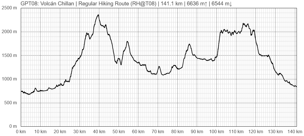
Elevation Profile of Regular Hiking Route

Elevation Profile of Regular Hiking Route (2019)
Regular Packrafting Route
Elevation Profile of Regular Packrafting Route

Elevation Profile of Regular Hiking Route (2019)
Optional Routes
Investigation and Exploration Tasks
Images
Related Routes on Wikiexplora
Related Blogs and Online Publications


