Diferencia entre revisiones de «GPT19 - Volcán Puyehue»
(→Summary Table) |
(→Season Section Log) (Etiquetas: Edición desde móvil, Edición vía web móvil) |
||
| Línea 29: | Línea 29: | ||
==Recent Alerts and Suggestions== | ==Recent Alerts and Suggestions== | ||
==Season Section Log== | ==Season Section Log== | ||
| + | |||
| + | |||
| + | |||
| + | 16-01-2020 / Arnaud Debilly / Southbound | ||
| + | 4 full days | ||
| + | We ressuplied in Curiñe, with a minimatket there. | ||
| + | To avoid the 15 first kilometers we took the bus from puerto Maihue to Rupumeica Bajo. We slept in the cabañas of Carmen Panguilef (+56 984 54 83 03) in rupumeica bajo who is very welcoming and a proud mapuche. | ||
| + | Then the road ends and starts the path to cross the pass to rupumeica alto. Then you follow the minor road until los Venados. The road is blocked by barriers that we crossed easily. At los Venados the path is clearly private and is along the house of Hector. We met him and his wife and they easily let us go through. | ||
| + | We overcarried water because we feared the lack of drinkable water. Until almost the treeline, you can hear little rivers not too far from the path. We also drunk melted snow at the top so we had enough. | ||
| + | Later in the season, it might be drier (I assume, those little rivers come from the snow melting). The last real rio is just before los venados. | ||
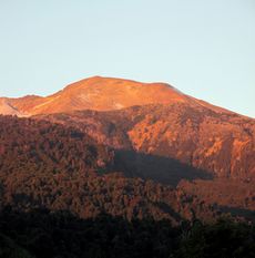
| + | After the forest, the volcanic terrain is very easy to walk in and the landscapes are wonderful. | ||
| + | We saw many smokes from the volcanic activity but seemed not dangerous. | ||
| + | Check the status of the volcano before to go (www.sernageomin.cl). | ||
| + | Following the track, it is easy to go between the lava field. | ||
| + | Campsites are absolutely great, with an amazing view on the vulcano. | ||
| + | We felt an earthquake (5,2) that has been localized near san martin de los andes in Argentinia but it made nothing dangerous with the volcano, luckily. | ||
| + | We have had a perfect blue sky without wind during the 2 days on top, it could not have been better. | ||
| + | The refugio El Caulle, at the start of the downhill can be a good protection for a bad weather. We found a little spring, to resupply water in the dry rio just under the refugio. | ||
| + | On the volcanic terrain, a bad weather changes everything and it must be really difficult and unpleasant to finish this section with rain, snow or wind and without the view. | ||
| + | It was for us the most wonderful section we have had until today. | ||
| + | |||
==Summary Table== | ==Summary Table== | ||
{| border="1" style="border-collapse:collapse" | {| border="1" style="border-collapse:collapse" | ||
Revisión del 13:39 16 ene 2020
| All GPT sections (click to show) |
|---|
|
GPT Section Articles
|
Recent Alerts and Suggestions
Season Section Log
16-01-2020 / Arnaud Debilly / Southbound 4 full days We ressuplied in Curiñe, with a minimatket there. To avoid the 15 first kilometers we took the bus from puerto Maihue to Rupumeica Bajo. We slept in the cabañas of Carmen Panguilef (+56 984 54 83 03) in rupumeica bajo who is very welcoming and a proud mapuche. Then the road ends and starts the path to cross the pass to rupumeica alto. Then you follow the minor road until los Venados. The road is blocked by barriers that we crossed easily. At los Venados the path is clearly private and is along the house of Hector. We met him and his wife and they easily let us go through. We overcarried water because we feared the lack of drinkable water. Until almost the treeline, you can hear little rivers not too far from the path. We also drunk melted snow at the top so we had enough. Later in the season, it might be drier (I assume, those little rivers come from the snow melting). The last real rio is just before los venados. After the forest, the volcanic terrain is very easy to walk in and the landscapes are wonderful. We saw many smokes from the volcanic activity but seemed not dangerous. Check the status of the volcano before to go (www.sernageomin.cl). Following the track, it is easy to go between the lava field. Campsites are absolutely great, with an amazing view on the vulcano. We felt an earthquake (5,2) that has been localized near san martin de los andes in Argentinia but it made nothing dangerous with the volcano, luckily. We have had a perfect blue sky without wind during the 2 days on top, it could not have been better. The refugio El Caulle, at the start of the downhill can be a good protection for a bad weather. We found a little spring, to resupply water in the dry rio just under the refugio. On the volcanic terrain, a bad weather changes everything and it must be really difficult and unpleasant to finish this section with rain, snow or wind and without the view. It was for us the most wonderful section we have had until today.
Summary Table
| GPT19: Volcán Puyehue | Hiking | Packrafting | |||||
| Group | D: Lagos Chilenos | Total | 83.0 km | 28 h | 70.0 km | 23 h | |
| Region | Chile: Los Ríos (XIV) & Los Lagos (X) | Trails (TL) | 5.4 km | 6.5% | 5.4 km | 7.8% | |
| Start | Puerto Maihue | Minor Roads (MR) | 55.8 km | 67.2% | 34.2 km | 48.8% | |
| Finish | Anticura (CONAF) | Primary Roads (PR) | 2.2 km | 2.6% | 2.2 km | 3.1% | |
| Status | Published & Verified | Cross-Country (CC) | 19.7 km | 23.7% | 18.6 km | 26.6% | |
| Traversable | Dec - Mar (Maybe: Nov, Apr) | Bush-Bashing (BB) | - | - | - | - | |
| Packraft | Useful | Ferry (FY) | - | - | - | - | |
| Connects to | GPT18, GPT20 | Investigation (I) | - | - | - | - | |
| Options | 216 km (6 Options & Variants) | Exploration (EXP) | - | - | - | - | |
| Hiking | Packrafting | Total on Water | 9.6 km | 13.8% | |||
| Attraction | 5 (of 5) | 5 (of 5) | River (RI) | - | - | ||
| Difficulty | 5 (of 5) | 5 (of 5) | Lake (LK) | 9.6 km | 13.8% | ||
| Direction | Both ↓↑ | Both ↓↑ | Fjord (FJ) | - | - | ||
| Comment | - | ||||||
| Character | Valdivian Rain Forest, Volcanic Terrain, Summit Ascents, Hot Springs, Settlers, Lake Packrafting | ||||||
| Challenges | Exposure to Elements, Demanding Navigation, Lack of Drinking Water | ||||||
Satellite Image Map
Elevation Profile
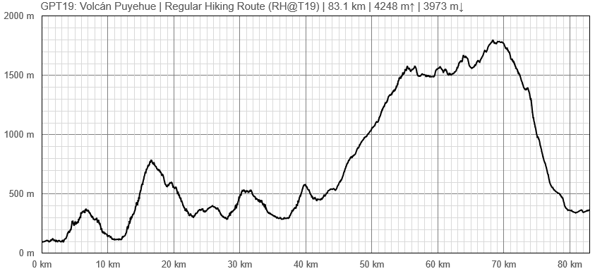
Elevation Profile of Regular Hiking Route
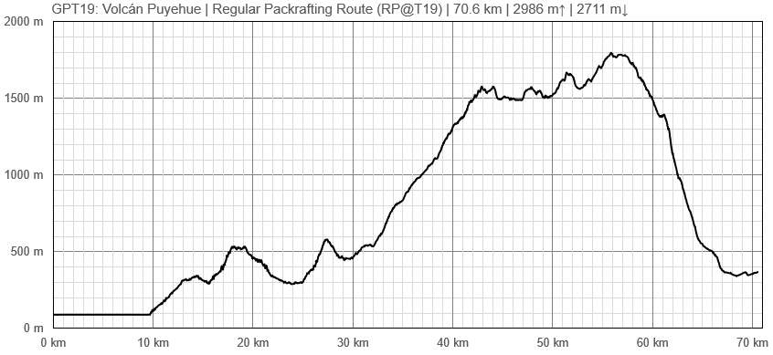
Elevation Profile of Regular Packrafting Route
Section Planning Status
Recommended Travel Period
Benefits of Hiking and Packrafting
Recommended Travel Direction
Section Length and Travel Duration
Suitable Section Combinations
Section Attractiveness
Section Difficulty
Resupply
Resupply Town
Shopping: Food
Shopping: Fuel
Shopping: Equipment
Services: Restaurants
Services: Laundry
Services: ATM and Money Exchange
Accommodation: Hostals and Hotels
Accommodation: Cabañas
Accommodation: Camping
Transport: Ground Transport
Transport: Ferries
Transport: Shipping Services
Resupply on the Trail
Location, Names, Available Items and Services
Access to Route and Return
Access to Start
Return from Finish
Escape Options
Permits, Entry Fees and Right-of-Way Issues
Regular Route
Regular Hiking Route
- Route description by Kara Davis after Season 2017/18:
GPT19 begins at the northeastern end of Lago Maihue. The regular hiking route follows T-559, a nice road with beautiful overlooking views of the lake, for many kilometers. Less than a kilometer after the GPS track turns east to contour the north bank of Río Hueinahue, the track turns off of T-559. There is no trail at the turn off, continue cross country until reaching the road on the other side. Be careful crossing this river! At high water, it may be a good idea to walk the few extra kilometers to the T-559 bridge crossing. The river is wide and the river bed was slippery.
Soon after rejoining T-559 on the south side of Río Hueinahue, turn right onto T-537 and begin to steeply climb. After about 2 kilometers, the road reduces to a very rutted trail with occasional spurs and limited camping. The route joins a gravel road T-567, for about 27 km until the turnoff onto Camino a Predio Contrafuerte, a smaller gravel road. After about 16 km, the road ends at a residence that the GPS route apparently goes right through. This house belongs to Nari and Hector, a wonderful older couple who are very used to hikers coming through their property on their way to Volcán Puyehue. Don’t be too alarmed with the barking dogs, go in and introduce yourself!
From Nari’s house, there is NO WATER until halfway down the descent of Volcán Puyehue!! It may be possible to grab a drink from some melting snow but don’t count on it during low snow years. Climb a wide rut up the hill behind Nari’s house. The rut reduces to single track and continues to climb through an open forest with plenty of places to camp. After reaching treeline, the trail disappears. You may see the occasional cairn or footprint, but for the most part this is cross-country travel until treeline on the south side of the volcano. The landscape through this section is alien and breathtakingly beautiful.
Just before the very steep descent at approximate elevation 1.400 m, there is a small hut which is popular with hikers climbing the volcano. Descend on a nice trail through the forest with limited camping options. As you approach the road, 215-CH, the route passes by several small cabins. Just west of where the route intersects 215-CH, is a bus stop. The nearest large town is Osorno (see town description in GPT20).


