Diferencia entre revisiones de «GPT39 - Monte Fitz Roy»
(→Season Section Log) |
(→Summary Table) |
||
| Línea 32: | Línea 32: | ||
==Summary Table== | ==Summary Table== | ||
| + | {| border="1" style="border-collapse:collapse" | ||
| + | |+'''GPT39: Monte Fitz Roy''' | ||
| + | | colspan="4" style="background-color:#bfbfbf;"| GPT39: Monte Fitz Roy | ||
| + | | colspan="2" style="background-color:#bfbfbf;"| Hiking | ||
| + | | colspan="2" style="background-color:#bfbfbf;"| Packrafting | ||
| + | |- | ||
| + | |style="background-color:#bfbfbf;"|Group | ||
| + | | colspan="2" | I: Campo de Hielo Sur 1 | ||
| + | |style="background-color:#bfbfbf;"| Total | ||
| + | |style="background-color:#ffbfbf;"|'''59.5 km''' | ||
| + | |style="background-color:#ffbfbf;"|'''17 h''' | ||
| + | |style="background-color:#c2edfc;"| '''64.7 km''' | ||
| + | |style="background-color:#c2edfc;"|'''17 h''' | ||
| + | |- | ||
| + | | style="background-color:#bfbfbf;"|Region | ||
| + | | colspan="2" | Argentina: Rio Negro | ||
| + | |style="background-color:#bfbfbf;"| Trails (TL) | ||
| + | |style="background-color:#ffbfbf;"|37.8 km | ||
| + | |style="background-color:#ffbfbf;"|63.6% | ||
| + | |style="background-color:#c2edfc;"| 26.2 km | ||
| + | |style="background-color:#c2edfc;"|40.5% | ||
| + | |- | ||
| + | |style="background-color:#bfbfbf;"| Start | ||
| + | | colspan="2" | Lago El Desierto (Gendarmeria) | ||
| + | |style="background-color:#bfbfbf;"| Minor Roads (MR) | ||
| + | |style="background-color:#ffbfbf;"|- | ||
| + | |style="background-color:#ffbfbf;"|- | ||
| + | |style="background-color:#c2edfc;"| - | ||
| + | |style="background-color:#c2edfc;"| - | ||
| + | |- | ||
| + | |style="background-color:#bfbfbf;"| Finish | ||
| + | | colspan="2" | El Chalten | ||
| + | |style="background-color:#bfbfbf;"| Primary Roads (PR) | ||
| + | |style="background-color:#ffbfbf;"|21.6 km | ||
| + | |style="background-color:#ffbfbf;"|36.4% | ||
| + | |style="background-color:#c2edfc;"| 9.4 km | ||
| + | |style="background-color:#c2edfc;"| 14.6% | ||
| + | |- | ||
| + | |style="background-color:#bfbfbf;"| Status | ||
| + | | colspan="2" | Published & Verified | ||
| + | |style="background-color:#bfbfbf;"| Cross-Country (CC) | ||
| + | |style="background-color:#ffbfbf;"|- | ||
| + | |style="background-color:#ffbfbf;"|- | ||
| + | |style="background-color:#c2edfc;"| 0.2 km | ||
| + | |style="background-color:#c2edfc;"| 0.3% | ||
| + | |- | ||
| + | |style="background-color:#bfbfbf;"| Traversable | ||
| + | | colspan="2" | Nov - Apr (Maybe: Sep, Oct, May) | ||
| + | |style="background-color:#bfbfbf;"| Bush-Bashing (BB) | ||
| + | |style="background-color:#ffbfbf;"|- | ||
| + | |style="background-color:#ffbfbf;"|- | ||
| + | |style="background-color:#c2edfc;"| - | ||
| + | |style="background-color:#c2edfc;"|- | ||
| + | |- | ||
| + | |style="background-color:#bfbfbf;"| Packraft | ||
| + | | colspan="2" | Very Useful | ||
| + | |style="background-color:#bfbfbf;"| Ferry (FY) | ||
| + | |style="background-color:#ffbfbf;"|- | ||
| + | |style="background-color:#ffbfbf;"|- | ||
| + | |style="background-color:#c2edfc;"| - | ||
| + | |style="background-color:#c2edfc;"|- | ||
| + | |- | ||
| + | |style="background-color:#bfbfbf;"| Connects to | ||
| + | | colspan="2" | GPT38, GPT40 | ||
| + | |style="background-color:#bfbfbf;"| Investigation (I) | ||
| + | |style="background-color:#ffbfbf;"|- | ||
| + | |style="background-color:#ffbfbf;"|- | ||
| + | |style="background-color:#c2edfc;"| - | ||
| + | |style="background-color:#c2edfc;"| - | ||
| + | |- | ||
| + | |style="background-color:#bfbfbf;"| Options | ||
| + | | colspan="2" | 73 km (2 Options & Variants) | ||
| + | |style="background-color:#bfbfbf;"| Exploration (EXP) | ||
| + | |style="background-color:#ffbfbf;"|- | ||
| + | |style="background-color:#ffbfbf;"|- | ||
| + | |style="background-color:#c2edfc;"| - | ||
| + | |style="background-color:#c2edfc;"|- | ||
| + | |- | ||
| + | | | ||
| + | |style="background-color:#bfbfbf;"| Hiking | ||
| + | |style="background-color:#bfbfbf;"| Packrafting | ||
| + | | rowspan="4" style="background-color:#bfbfbf;"| | ||
| + | | colspan="2" style="background-color:#bfbfbf;"| Total on Water | ||
| + | |style="background-color:#c2edfc;"| '''28.9 km''' | ||
| + | |style="background-color:#c2edfc;"| '''44.6%''' | ||
| + | |- | ||
| + | |style="background-color:#bfbfbf;"| Attraction | ||
| + | |style="background-color:#ffbfbf;"|4 (of 5) | ||
| + | |style="background-color:#c2edfc;"| 4 (of 5) | ||
| + | | colspan="2" style="background-color:#bfbfbf;"| River (RI) | ||
| + | |style="background-color:#c2edfc;"| 18.2 km | ||
| + | |style="background-color:#c2edfc;"| 28.1% | ||
| + | |- | ||
| + | |style="background-color:#bfbfbf;"| Difficulty | ||
| + | |style="background-color:#ffbfbf;"|1 (of 5) | ||
| + | |style="background-color:#c2edfc;"| 4 (of 5) | ||
| + | | colspan="2" style="background-color:#bfbfbf;"| Lake (LK) | ||
| + | |style="background-color:#c2edfc;"| 10.7 km | ||
| + | |style="background-color:#c2edfc;"| 16.5% | ||
| + | |- | ||
| + | | style="background-color:#bfbfbf;"|Direction | ||
| + | |style="background-color:#ffbfbf;"|Both ↓↑ | ||
| + | |style="background-color:#c2edfc;"|Both ↓↑ | ||
| + | | colspan="2" style="background-color:#bfbfbf;"| Fjord (FJ) | ||
| + | |style="background-color:#c2edfc;"| - | ||
| + | |style="background-color:#c2edfc;"|- | ||
| + | |- | ||
| + | |style="background-color:#bfbfbf;"| Comment | ||
| + | | colspan="7" | - | ||
| + | |- | ||
| + | |style="background-color:#bfbfbf;"| Character | ||
| + | | colspan="7" | Forest, Glaciers, River Packrafting, Lake Packrafting, Road Walking, Partly Overrun | ||
| + | |- | ||
| + | |style="background-color:#bfbfbf;"| Challenges | ||
| + | | colspan="7" | - | ||
| + | |} | ||
| + | |||
==Satellite Image Map== | ==Satellite Image Map== | ||
==Elevation Profile== | ==Elevation Profile== | ||
Revisión del 09:26 11 dic 2019
| All GPT sections (click to show) |
|---|
|
GPT Section Articles
|
Recent Alerts and Suggestions
Season Section Log
- 2019-Nov-9 / Lea Geibel, Kevin Moe / 2 days / northbound / regular hiking route
The highlight of this section for us was visiting all the lagunas in the national park! We cheated and hitch hiked along the road when we hit it after El Pilar. It was not difficult to get a car in the morning when tourists are heading out to Lago Desierto; it might be harder to find one northbound in the evening would be my guess. It's necessary to pay to camp at Desierto, 800 Argentinian Pesos each, and it is not allowed to camp along the road.
Summary Table
| GPT39: Monte Fitz Roy | Hiking | Packrafting | |||||
| Group | I: Campo de Hielo Sur 1 | Total | 59.5 km | 17 h | 64.7 km | 17 h | |
| Region | Argentina: Rio Negro | Trails (TL) | 37.8 km | 63.6% | 26.2 km | 40.5% | |
| Start | Lago El Desierto (Gendarmeria) | Minor Roads (MR) | - | - | - | - | |
| Finish | El Chalten | Primary Roads (PR) | 21.6 km | 36.4% | 9.4 km | 14.6% | |
| Status | Published & Verified | Cross-Country (CC) | - | - | 0.2 km | 0.3% | |
| Traversable | Nov - Apr (Maybe: Sep, Oct, May) | Bush-Bashing (BB) | - | - | - | - | |
| Packraft | Very Useful | Ferry (FY) | - | - | - | - | |
| Connects to | GPT38, GPT40 | Investigation (I) | - | - | - | - | |
| Options | 73 km (2 Options & Variants) | Exploration (EXP) | - | - | - | - | |
| Hiking | Packrafting | Total on Water | 28.9 km | 44.6% | |||
| Attraction | 4 (of 5) | 4 (of 5) | River (RI) | 18.2 km | 28.1% | ||
| Difficulty | 1 (of 5) | 4 (of 5) | Lake (LK) | 10.7 km | 16.5% | ||
| Direction | Both ↓↑ | Both ↓↑ | Fjord (FJ) | - | - | ||
| Comment | - | ||||||
| Character | Forest, Glaciers, River Packrafting, Lake Packrafting, Road Walking, Partly Overrun | ||||||
| Challenges | - | ||||||
Satellite Image Map
Elevation Profile
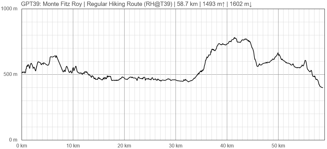
Elevation Profile of Regular Hiking Route
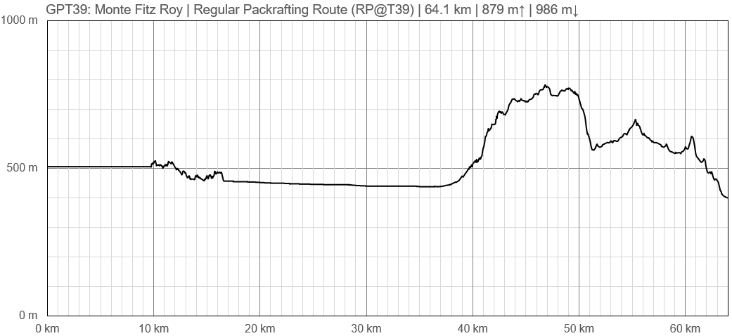
Elevation Profile of Regular Packrafting Route
Section Planning Status
Recommended Travel Period
Benefits of Hiking and Packrafting
Recommended Travel Direction
Section Length and Travel Duration
Suitable Section Combinations
Section Attractiveness
Section Difficulty
Resupply
Resupply Town
Town: El Chaltén
El Chaltén is a medium sized town with several hostels, restaurants, and decent resupply options. There were also a few outdoor gear outfitters which offered rentals for the famous Huemul Circuit (GPT40).
It is good to note that there are many beautiful day hikes from this area as well. The GPT39 packrafting and hiking route does overlap with some of these hikes, but if time allows, hiking to Lago de los Tres or any of the other lakes at the base of Monte Fitz Roy is well worth it.
Shopping: Food
Shopping: Fuel
Shopping: Equipment
Services: Restaurants
Services: Laundry
Services: ATM and Money Exchange
Accommodation: Hostals and Hotels
Accommodation: Cabañas
Accommodation: Camping
Transport: Ground Transport
Transport: Ferries
Transport: Shipping Services
Resupply on the Trail
Location, Names, Available Items and Services
Access to Route and Return
Access to Start
Return from Finish
Escape Options
Permits, Entry Fees and Right-of-Way Issues
Regular Route
Regular Hiking Route
Regular Packrafting Route
- Route description by Kara Davis after Season 2017/18:
Section GPT39 begins on the northern bank of Lago del Desierto. According to the Gendarmería, the Argentine Border Control, the wind patterns on the lake are unpredictable and shift frequently. There is also no good access to the trail on the east side if bailing becomes a necessity, so have caution when deciding whether to packraft or not.
Comment by Jan Dudeck: Lago del Desierto is an innocent looking beast. While very calm at the put in heavy wind at the middle of the lake can make a traverse demanding and dangerous.
There is a well-established trail that runs along the east side of the lake. However, it isn’t flat, and the 11 or so kilometers takes longer than expected. There is an option to take a ferry across the lake which is popular with Carretera Austral bicyclers. More information regarding times and prices can be found at the Argentine border control station on the north side of Lago del Desierto.
Hungry hikers are rewarded when they reach the south end of the lake. A burger stand with some snack options is located here along with an established campground with showers, flush toilets, and a communal kitchen.
Walk along RP23, a gravel road, for several kilometers until reaching the put-in for the packrafting section of Río de las Vueltas, which is a sloped rocky beach. The serpentine river section before Lago Condor is fairly swift with no rapids, only some wooden snags. After Lago Condor, the river widens and forms many braided channels.
Alternate: Instead of exiting Río de las Vueltas onto RP23 as shown by the GPS track, we floated the river al the way to El Chaltén and took out just after the bridge crossing east of the town.
- Comment by Jan Dudeck:
To my knowledge packrafting the Rio de las Vueltas all the way to El Chalten requires a permit by the park rangers. Without this permit park rangers might get very nasty and may even confiscate your packraft. So better leave the river before this river enters the national park. Packraft track OP-RI-1@39-02-# only if you have a permit.


