Diferencia entre revisiones de «GPT72 - Bajo Río Futaleufú»
De Wikiexplora
(→Recent Alerts and Suggestions) (Etiquetas: Edición desde móvil, Edición vía web móvil) |
(Página redirigida a GPT72 (Bajo Rio Futaleufu)) |
||
| (No se muestra una edición intermedia de otro usuario) | |||
| Línea 1: | Línea 1: | ||
| + | #Redirect [[GPT72 (Bajo Rio Futaleufu)]] | ||
{{Draft}} | {{Draft}} | ||
{{RutaForme | {{RutaForme | ||
| Línea 158: | Línea 159: | ||
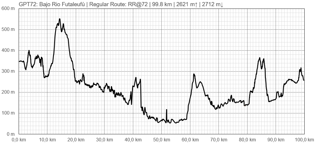
==Elevation Profile== | ==Elevation Profile== | ||
[[File:perfil greater patagonian trail 72.PNG|frame|center|Profile of GPT72: Bajo Río Futaleufú]] | [[File:perfil greater patagonian trail 72.PNG|frame|center|Profile of GPT72: Bajo Río Futaleufú]] | ||
| + | |||
==Section Planning Status== | ==Section Planning Status== | ||
==Recommended Travel Period== | ==Recommended Travel Period== | ||
Revisión actual del 20:36 2 dic 2024
Redirige a:
This article is just a draft. You can help by expanding and improving its content
| All GPT sections (click to show) |
|---|
|
GPT Section Articles
|
Recent Alerts and Suggestions
- 6 to 8-Jan-2020 / Martin Lizondo / Regular Hiking Southbound
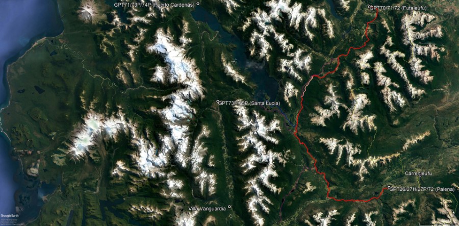
The first 40 km are minor road walking and enjoyable horse trails. According to locals, at 43°21'10"S 72°03'22"W the track isn’t possible to follow because the old trail doesn’t exist anymore, so one must cross the bridge and follow the primary road down to Palena.
Season Section Log
Summary Table
| GPT72: Bajo Río Futaleufú | Hiking | Packrafting | |||||
| Group | M: Sector Yelcho | Total | 99.6 km | 27 h | 99.6 km | 27 h | |
| Region | Chile: Los Lagos (X) | Trails (TL) | 21.5 km | 21.6% | 21.5 km | 21.6% | |
| Start | Villa Futaleufú | Minor Roads (MR) | 42.8 km | 43.0% | 42.8 km | 43.0% | |
| Finish | Palena | Primary Roads (PR) | 35.3 km | 35.4% | 35.3 km | 35.4% | |
| Status | Published & Mostly Verified | Cross-Country (CC) | - | - | - | - | |
| Traversable | Sep - May | Bush-Bashing (BB) | - | - | - | - | |
| Packraft | Useful | Ferry (FY) | (0.1 km) | (0.1%) | (0.1 km) | (0.1%) | |
| Connects to | GPT26, GPT27H, GPT27P, GPT70, GPT71, GPT73P | Investigation (I) | (7.0 km) | (7.0%) | (7.0 km) | (7.0%) | |
| Options | 75 km (2 Options & Variants) | Exploration (EXP) | - | - | - | - | |
| Hiking | Packrafting | Total on Water | - | - | |||
| Attraction | 1 (of 5) | - | River (RI) | - | - | ||
| Difficulty | 2 (of 5) | - | Lake (LK) | - | - | ||
| Direction | Both ↓↑ | - | Fjord (FJ) | - | - | ||
| Comment | - | ||||||
| Character | Valdivian Rain Forest, Farmland, Settlers, Road Walking | ||||||
| Challenges | - | ||||||


