Diferencia entre revisiones de «GPT77 - PN Pumalin Norte»
(→Elevation Profile) |
(→Season Section Log, Recent Alerts and Suggestions) |
||
| Línea 31: | Línea 31: | ||
==Season Section Log, Recent Alerts and Suggestions== | ==Season Section Log, Recent Alerts and Suggestions== | ||
| + | |||
| + | |||
| + | * GPT77 and GPT76 / Hiking Option from Hornopiren to Chaiten | ||
| + | |||
| + | Dates: 2023-November-21st for 8 days | ||
| + | Direction: Southbound | ||
| + | Participants: Jordan Jennings | ||
| + | |||
| + | After arriving in Chaiten from Rio Yelcho, I initially tried travelling northbound towards Caleta Gonzalo. I only made it to Santa Barbara before facing moderate but unpleasant headwinds. Because of the forecast, I decided to return to Chaiten and travel to Hornopiren, to travel southbound. I think this is the wisest thing to do in any case. Jan mentions northbound travel because of Yelcho, but this is only really possible if you slam dunk good weather. | ||
| + | |||
| + | In terms of wind- as Jan mentioned - stable/calm weather combined with sunny days creates southerlies from 11am(ish) while the weather during my stay in the area brought prevailing northerlies outside of sunny weather windows. On sunny days, the southerly however, is redirected as a northerly down Fiordo Comau (first stretch from Hornopiren). In terms of apps, Windy is great, but Windfinder.com (location Chaiten Aeródromo) was more accurate. I waited for almost a week in Hornopiren for a decent weather window, although I was told by locals it was an unusual bad spell. | ||
| + | |||
| + | Fiordo Comeu is stunning and should not be rushed - I took Jan’s advice and stayed an extra day to packraft Lago Abascal and it was an absolute highlight. I packrafted down the river back to the thermals campsite - I would only recommend doing if you have a friend with you and whitewater experience. It’s fun, but was sketchy for me doing alone. There was one section that was perhaps a class II+ or III-. | ||
| + | |||
| + | Overall incredible experience, saw a lot of dolphins, seals, penguins | ||
| + | |||
| + | |||
| + | |||
* GPT77 and GPT76 / Hiking Option from Hornopiren to Chaiten | * GPT77 and GPT76 / Hiking Option from Hornopiren to Chaiten | ||
Revisión del 19:10 1 dic 2023
| All GPT sections (click to show) |
|---|
|
GPT Section Articles
|
Season Section Log, Recent Alerts and Suggestions
- GPT77 and GPT76 / Hiking Option from Hornopiren to Chaiten
Dates: 2023-November-21st for 8 days Direction: Southbound Participants: Jordan Jennings
After arriving in Chaiten from Rio Yelcho, I initially tried travelling northbound towards Caleta Gonzalo. I only made it to Santa Barbara before facing moderate but unpleasant headwinds. Because of the forecast, I decided to return to Chaiten and travel to Hornopiren, to travel southbound. I think this is the wisest thing to do in any case. Jan mentions northbound travel because of Yelcho, but this is only really possible if you slam dunk good weather.
In terms of wind- as Jan mentioned - stable/calm weather combined with sunny days creates southerlies from 11am(ish) while the weather during my stay in the area brought prevailing northerlies outside of sunny weather windows. On sunny days, the southerly however, is redirected as a northerly down Fiordo Comau (first stretch from Hornopiren). In terms of apps, Windy is great, but Windfinder.com (location Chaiten Aeródromo) was more accurate. I waited for almost a week in Hornopiren for a decent weather window, although I was told by locals it was an unusual bad spell.
Fiordo Comeu is stunning and should not be rushed - I took Jan’s advice and stayed an extra day to packraft Lago Abascal and it was an absolute highlight. I packrafted down the river back to the thermals campsite - I would only recommend doing if you have a friend with you and whitewater experience. It’s fun, but was sketchy for me doing alone. There was one section that was perhaps a class II+ or III-.
Overall incredible experience, saw a lot of dolphins, seals, penguins
- GPT77 and GPT76 / Hiking Option from Hornopiren to Chaiten
Dates: 2021-Nov-30 Direction: SoBo Participants: Meylin Elisabeth Ubilla González and Jan Dudeck
With the land border between Chile and Argentina still closed hikers can not cross into Argentina on section GPT22 but can continue hiking southbound by walking section GPT78 from Rio Puelo to Hornopiren. See my previous post to this section.
From Hornopiren two daily ferries carry passengers and cars to Caleta Gonzalo. The early ferry departs in Hornopiren at 8 am and a second ferry departs in Hornopiren at 10:30 am.
Both ferries go to Leptepu from where a bus carries passengers (without a car) to Fiordo Largo (approx. 12 km). From Fiordo Largo a second ferry carries cars and passengers to Caleta Gonzalo. On the later ferry that departs at 10:30 in Hornopiren is the daily bus that departs in the morning in Puerto Montt and arrives at 16:00 in Chaiten.
Hikers can sweaten this ferry trip by visiting the Termas de Porcelano about 4 km north of Leptepu. These natural hot springs are one of the finest in this region. This requires a boat transfer from Leptepu to Punta Porcelana and back (about 20’000 to 30’000 CLP per boat with up to 6 passangers). A nearby hospedaje offers accommodation (about 25’000 CLP per day per person including meals). Alternatively hikers may ask for permission to camp near the beach.
On two days per week (Tuesday and Friday) a subsidized small ferry (passengers only) visits all the tiny settlements between Hornopiren and Leptepu including Punta Porcelana next to the hot spings what cuts cost of the boat transfer (only one boat transfer for about 15’000 CLP from Punta Porcelana to Leptepu). This subsidized ferry departs at 1 pm in Hornopiren and is called Serenade II.
Contacts:
Boat transfer between Leptepu and Punta Porcelana and accomodation near Punta Porcelana: Mabel +56-9-87696084
Termas de Porcelana: Marlyn +56-9-90978870 (you may buy bread and homemade marmalade from Marlyn)
Subsidized ferry Serenade II: Alejandro Jobis +56-9-87696084 (Tuesday and Friday only).
Hikers the plan to walk section GPT76 from Caleta Gonzalo to Chaiten may take the early ferry that departs at 8:00 am in Hornopiren and check after arrival in Caleta Gonzalo if a boat is available to carry hikers towards Loyola to hike section GPT76 southbound.
If there is no boat available in Caleta Gonzalo hikers best wait for the second ferry that arrives 2:30 h later. On the second ferry is the bus to Chaiten. From Chaiten hikers can walk section GPT76 northbound. Once in Loyola hikers will find more people with boats in this larger settlement so it is generally easier to arrange a boat transfer from Loyola to Caleta Gonzalo than the other way around.
- GPT77 / Packrafting from Hornopiren to Caleta Gonzalo
Dates: 2021-Nov-30 to 2021-Dec-06 Direction: NoBo and SoBo (Leptepu-Termas de Porcelana-Cahuelmo-Laguna Abascal-Vodudahue) Participants: Meylin Elisabeth Ubilla González and Jan Dudeck
The often strong wind in these fjords makes packrafting challenging and more risky if attempted with an open packraft without spraydeck. Therefore a decked packraft is the recommended gear.
The recommended travel direction is southbound due to the predominant wind direction.
Packrafting should only be attempted if the weather forecast predicts calm weather or moderate wind only.
On good-weather days with the typical daily wind pattern the morning from sunrise to about 10 am or noon is generally calm and them the “viento sur” kicks in that lasts till 5 pm or 7 pm. The “viento sur” quickly builds up high waves thats makes packrafting unpleasant or even impossible especially with an open packraft. Therefore it is essential to get up in the night and start paddling with the first daylight around sunrise. The best days for packrafting are overcasted calm days. On such days “viento sur” is less dominant.
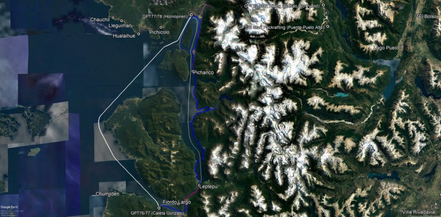
Two legs require paddling 20 km in one go between suitable camps (Pichanco to Termas de Cahuelmo / Termas de Cahuelmo to Huinay). So getting up early and racing against the clock is essential to not get pinned down by strong wind halfway.
Highlights are the Termas de Cahuelmo, Laguna Abascal and the Termas Porcelana.
Termas de Cahuelmo: Are located at the eastern end of the Fiordo Cahuelmo. The pools offer the perfect view into the fjord. A refuge facilitates cooking in rainy weather. There are several spots for tents in forest next to the hot springs.
Laguna Abascal: Is location about 3 km east of the Termas de Cahuelmo. At low tide packrafters can walk 1 km cross-country to the trailhead, otherwise packrafters better paddle by packraft to the trailhead as the river arms quickly become flooded by the rising tide. From the trailhead a well maintained 2 km short trail leads to Laguna Abascal. Paddling this lake by packraft is highly recommended. The lake is surrounded by steep mountains with few beaches for camping. We slept one night in the refuge at the trail end next to Laguna Abascal and returned on the next morning to the Termas de Cahuelmo.
Termas de Porcelana: Are located 4 km north of Leptepu and definitely worth a visit. You can ask for permission to camp next to the beach. Contact Marlyn +56-9-90978870 (you may buy bread and homemade marmalade from Marlyn)
In Leptepu is a nice refuge right where the ferries arrive.
From Leptepu packrafters may walk the road and enter the Fundo Pillan to get to Estero Pillan where you may camp next to the beach. The 12 km from Estero Pillan to Caleta Gonzalo are feasible against the predominant wind direction in a calm morning if leaving with sunrise. Strong tidal currents occur at narrow at the river delta of Rio Renihue. If needed leave the packraft and pull it against the current along the edge of the river delta.
Sections GPT74P and GPT76 are only recommended in northbound direction (river flow direction and predominant wind). Therfore, after arrival in Caleta Gonzalo best take the bus to Chaiten that arrives with the ferry in Cateta Gonzalo around 15:00 and take a second bus to Puerto Cardenas after resupplying in Chaiten.
- GPT77 and GPT76 Option 3/ Packrafting from Hornopirén to Chaitén
Dates: 2021-Dec-03 Direction: SoBo Participant: Tobías Schorcht
Did the stretch from Hornopirén to Caleta Gonzalo in a open Packraft in 3 days. The most challenging Parts are the Canal Comau and the Fjordo Largo. Watch carfully the tides and wind and stay close to the shore, since the weather can change quickly.
From Caleto Gonzalo I did some roadwalking through Parce Pumalin, went up to the viewpoint Volcán Chaitén and took the Option 3,GPT76 down to Chaitén. I would Not recomment to do that. At least not southbounded. It requires a lot of Nalca bashing and climbing by the River Chaitén. I felt down once and hurt my shoulder badly. Better take the Option Jan recommented (Loyola, Chumelden).
- 30-Dec-19 / Martín Lizondo / Regular hiking southbound
GPT 77 / 30-Dec-19 / Reg Hiking Southbound
At Hornopiren there are three ferries. Leaving schedule is at 9 am, 10:30 am and at 00 hs from Hornopirén. Reservation is made the day before or the same day since 8:30 am. There’s a bus between Leptepu and Fiordo Largo, with an obligatory boat transfer included to Caleta Gonzalo. The trip takes around 5 hours. Cost = CLP 5700. In Caleta Gonzalo there’s a camping with services. GPT 76: The boat to Loyola and Chumilden leaves Caleta Gonzalo on monday, tuesday, wednesday and friday. Conract: Roberto Btos +56 9 85564749. Cost = CLP 2400 per person. Also locals travel by small boats between Caleta Gonzalo to Loyola and Chumilden and can pick you up for some money.
Summary Table
| GPT77: PN Pumalin Norte | Hiking | Packrafting | |||||
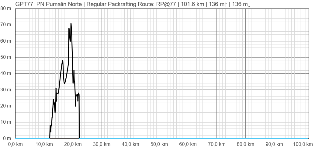
| Group | N: Fiordos Norte | Total | 1.0 km | 0 h | 101.6 km | 28 h | |
| Region | Chile: Los Lagos (X) | Trails (TL) | - | - | 0.3 km | 0.3% | |
| Start | Caleta Gonzalo | Minor Roads (MR) | 1.0 km | 100.0% | 2.5 km | 2.4% | |
| Finish | Hornopirén | Primary Roads (PR) | - | - | 8.1 km | 8.0% | |
| Status | Published & Verified | Cross-Country (CC) | - | - | - | - | |
| Traversable | Sep - May | Bush-Bashing (BB) | - | - | - | - | |
| Packraft | Very Useful | Ferry (FY) | (85.3 km) | (98.8%) | - | - | |
| Connects to | GPT76, GPT78 | Investigation (I) | - | - | - | - | |
| Options | 199 km (3 Options & Variants) | Exploration (EXP) | - | - | - | - | |
| Hiking | Packrafting | Total on Water | 90.8 km | 89.3% | |||
| Attraction | - | 5 (of 5) | River (RI) | - | - | ||
| Difficulty | - | 5 (of 5) | Lake (LK) | - | - | ||
| Direction | Both ↓↑ | Both ↓↑ | Fjord (FJ) | 90.8 km | 89.3% | ||
| Comment | Hiking: Ferry | ||||||
| Character | Packrafting: ↑ Preferable due preceding section GPT74P Río Yelcho and predominant wind direction | ||||||
| Challenges | Valdivian Rain Forest, Sea Coast, Hot Springs, Fjord Packrafting | ||||||


