Diferencia entre revisiones de «GPT24P - PN Los Alerces Agua»
(→Regular Packrafting Route) |
(→Elevation Profile of Regular Packrafting Route) |
||
| Línea 158: | Línea 158: | ||
====Elevation Profile of Regular Packrafting Route==== | ====Elevation Profile of Regular Packrafting Route==== | ||
[[File:profile GPT24-p.PNG|frame|center|Elevation Profile of Regular Hiking Route (2019)]] | [[File:profile GPT24-p.PNG|frame|center|Elevation Profile of Regular Hiking Route (2019)]] | ||
| + | |||
==Section Planning Status== | ==Section Planning Status== | ||
==Recommended Travel Period== | ==Recommended Travel Period== | ||
Revisión del 19:54 1 sep 2023
| All GPT sections (click to show) |
|---|
|
GPT Section Articles
|
Recent Alerts and Suggestions
Season Section Log
- January 11-13 / Zach/ Villa Rivadavia ➡️ Villa Futalaufquen / 3 days
When I arrived at Lago Rivadavia at 2 PM the wind was in full force. The next morning was calm as could be. It took 4.5 scenic hours to the south end where a rope across Rio Rivadalvia prevents motorized boats and a sign states you must be accompanied by a guide or register with park authorities. Perhaps this is why 2 fly fishing guides scolded me from the other side of the river for scaring away their fish. Paddle delicately and perhaps ask permission before passing. Nobody but fish after the first rapid. This river is stunning. The trail to the mirador on Lago Menéndez is a good opportunity to stretch the legs. There’s a cafe with snacks and 400 peso/30 minute WIFI on the East side of the pasarela (footbridge). Great wind ride on Lago Futalaufquen all the way to Villa Futalaufquen. Some nice sheltered spots at the almost empty Camping Libre Las Rocas East of Villa Futalaufquen. From there to Palena on a weekend when busses don’t run it took 8 hours including groceries in Travelin and some walking. Don’t forget about the veggie police (aka aduana iguanas) at the border crossing.
- 2020-Jan-13-14 / Shaun / Regular hiking route southbound
I hiked section 24H, but want to pass on to packrafters that park rangers confirmed that the trail from Lago Krügger to Villa Futalaufquen is open for its entire length, not just from Playa Blanca. There is no longer a ferry service from Punta Mattos to Lago Krugger so hikers can not cross the lake and hike this trail to Villa Futalaufquen. There is a daily ferry service from Puerto Limonao (3km north of VF) to Lago Krugger at noon, and returns at 19:00. There is a Refugio at Lago Krugger.
Summary Table
| GPT24P: PN Los Alerces Agua | Hiking | Packrafting | |||||
| Group | E: Lagos Argentinos | Total | - | - | 51.4 km | 13 h | |
| Region | Argentina: Chubut | Trails (TL) | - | - | - | - | |
| Start | Villa Lago Rivadavia | Minor Roads (MR) | - | - | 0.4 km | 0.8% | |
| Finish | Lago Kruger Lodge | Primary Roads (PR) | - | - | 0.9 km | 1.7% | |
| Status | Published & Verified | Cross-Country (CC) | - | - | - | - | |
| Traversable | Nov - Apr (Maybe: Sep, Oct, May) | Bush-Bashing (BB) | - | - | - | - | |
| Packraft | Very Useful | Ferry (FY) | - | - | - | - | |
| Connects to | GPT23, GPT24H, GPT25H, GPT25P | Investigation (I) | - | - | - | - | |
| Options | None | Exploration (EXP) | - | - | - | - | |
| Hiking | Packrafting | Total on Water | 50.2 km | 97.5% | |||
| Attraction | - | 5 (of 5) | River (RI) | 17.8 km | 34.6% | ||
| Difficulty | - | 4 (of 5) | Lake (LK) | 32.3 km | 62.9% | ||
| Direction | None | Both ↓↑ | Fjord (FJ) | - | - | ||
| Comment | Hiking: Hiking not feasible | ||||||
| Character | Packrafting: ↓ More packraft use | ||||||
| Challenges | Forest, Settlers, River Packrafting, Lake Packrafting | ||||||
Satellite Image Map
Elevation Profile
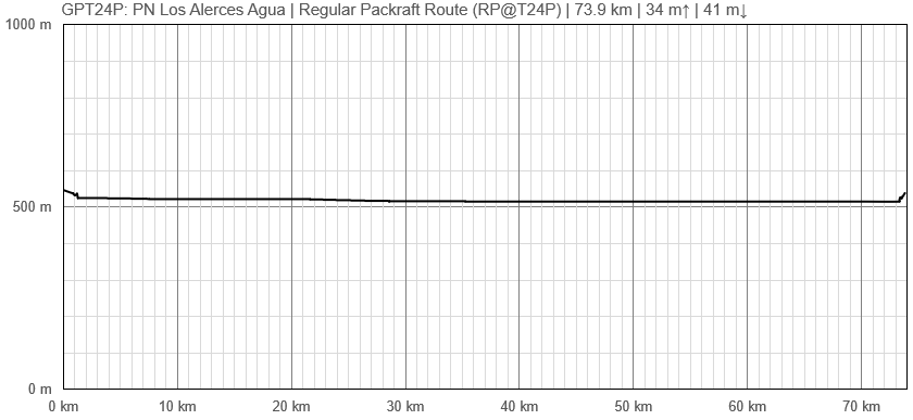
Elevation Profile of Regular Packrafting Route
Section Planning Status
Recommended Travel Period
Benefits of Hiking and Packrafting
Recommended Travel Direction
Section Length and Travel Duration
Suitable Section Combinations
Section Attractiveness
Section Difficulty
Resupply
Resupply Town
Town: Villa Futalaufquen
Villa Futalaufquen is a small, tidy town at the southern end of Lago Futalaufquen. There is a little store offering snacks, cheese, and bread. An information station for Los Alerces National Park is located here. This station is a good resource to gain information about the surrounding area, including GPT25P and GPT25H.
Shopping: Food
Shopping: Fuel
Shopping: Equipment
Services: Restaurants
Services: Laundry
Services: ATM and Money Exchange
Accommodation: Hostals and Hotels
Accommodation: Cabañas
Accommodation: Camping
Transport: Ground Transport
Transport: Ferries
Transport: Shipping Services
Resupply on the Trail
Location, Names, Available Items and Services
Access to Route and Return
Access to Start
Return from Finish
Escape Options
Permits, Entry Fees and Right-of-Way Issues
Regular Route
Regular Hiking Route
Regular Packrafting Route
- Route description by Kara Davis after Season 2017/18:
GPT24P begins on the Río Carrileufu at the take-out for GPT23P. This is a very enjoyable, calm float all the way to Lago Rivadavia.
There are several nice places to camp along the east shore of Lago Rivadavia. However, several of the beaches are also popular day trip areas because of the easy access to the shoreline provided by the road, RP71.
You’ll begin to pick up speed as you near the lake outlet into Río Rivadavia. There’s a sign here prohibiting motorized boats from entering the river. Río Rivadavia is swift and narrow with several small rapids and obstacles, such as fallen trees. There are many places to camp under the tree cover on the left bank for the first 500 m or so after exiting Lago Rivadavia.
After floating into Lago Verde, you’ll notice several beaches along the east bank that are fairly popular during the summer months. There is no obvious camping on the west bank. At the outlet of Lago Verde, about 200 m after the pedestrian bridge crosses over the water, the river splits. A rope stretches across the entrance to the west fork, which flows to Lago Menédez, preventing boaters from entering (for good reason due to some violent rapids). The river stretch between Lago Verde and Lago Futalaufquen is wide, slow, and free of rapids.
On Lago Futalaufquen, there is a free campsite, Punta Mattos, just off of RP71 where the northwest branch of the lake intersects the larger body of water approximately 7 km after entering the lake. There is trash disposal here but no running water nor toilet.
At this point, there is a choice whether to continue south towards Lago Krügger and GPT25P or east towards Villa Futalaufquen and GPT25H. SEE “GPT25P: Lago Amutui Quimei” BEFORE CHOOSING TO GO TOWARD THIS ROUTE!


