Diferencia entre revisiones de «GPT78 - Estuario de Reloncaví»
(→Recent Alerts and Suggestions) (Etiquetas: Edición desde móvil, Edición vía web móvil) |
(→Season Section Log, Recent Alerts and Suggestions) (Etiquetas: Edición desde móvil, Edición vía web móvil) |
||
| Línea 30: | Línea 30: | ||
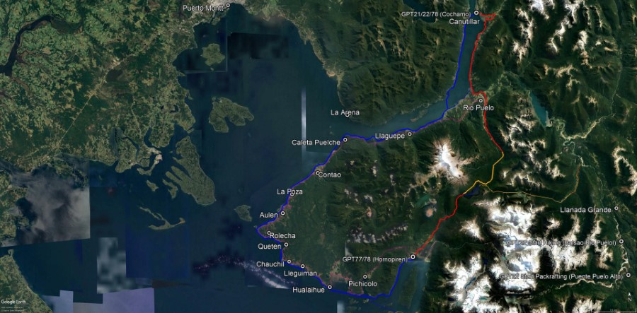
[[File:GPT78 Satellite Image.jpg|frame|center|Overview of GPT78: Estuario de Reloncaví]] | [[File:GPT78 Satellite Image.jpg|frame|center|Overview of GPT78: Estuario de Reloncaví]] | ||
| − | ==Recent Alerts and Suggestions== | + | ==Season Section Log, Recent Alerts and Suggestions== |
| − | 28/29-Dec-2019 / Martín Lizondo / Regular Hiking Southbound | + | * GPT78 / Land traverse from Rio Puelo to Hornopiren / 2021-Nov-25 to 2021-Nov-28 / Meylin Elisabeth Ubilla González and Jan Dudeck |
| + | | ||
| + | First: Thank you Linda Bortoletto and Martin Lizondo for recording this route when being guided by Patricio Bayer in season 2019/20. And thank you for leaving a positive memory with Patricio Bayer. We were granted permission to cross his property after a phone call. | ||
| + | |||
| + | This route connects Rio Puelo with Hornopiren via Lago Pinto Concha. Highlights are the dense Valdivian Rainforest, the gigantic Alerce trees, the wetlands on the plateau with Cypress trees, the traverse of the volcanic terrain of volcan Yates and the lake Pinto Concha. | ||
| + | |||
| + | This route was created many decades ago to drive cattle from the Puelo valley to the coast before a road was build along the Puelo river. Now this route is barely used and only the trail section inside the National Park Hornopiren towards Hornopiren is well maintained. | ||
| + | |||
| + | This route is best hiked southbound and only after obtaining permission from Patricio Beyer by phone (+56 9 8132 4070 and +56 9 9573 5461). You will also cross the property of Eulogio (Lalo) Soto who will probably checks by phone with Patricio Beyer first before letting you pass. He will charge an entrance fee of 5000 CLP per person. | ||
| + | |||
| + | The route is now slightly altered on the northern end to facilitate a otherwise very demanding river crossing (Diversion from Regular Route at: S 41.7806 / W 72.2403 … Now recommended river ford: S 41.7771 / W 72.2359 … Rejoin Regular Route at: S 41.7803 / W 72.7204). This part of the trail is generally well maintained and visible. | ||
| + | |||
| + | The navigation challenge starts south of the Puesto of Patricio Bayer (Point: Settler {78} [37.6/398]) and ends when leaving the forrest towards the lava field of Volcan Yates (southern end of track: RH-TL&BB-V {78} [24.6+16.8]). A good part of the trail is rarely used and poorly maintained and many animal tracks make the “main trail” often indistinguishable from other weakly visible tracks. But the often dense vegetation and the irregular geography make following the “main trail” essential. | ||
| + | |||
| + | We verified our position typically every 50 m, sometimes even more often. The internal compass of our handheld GPS was very helpful to frequently realign us to the “main trail” that takes many unexpected turns and twists. | ||
| + | |||
| + | I assume we are the first hikers in many years that walk this route without a guide. But even with a very precise GPS record the navigation was unexpected demanding. We consumed substantially more GPS battery power than normal due to the frequent checks and we still accidentally wandered of the “main trail” often. Hikers have no chance to traverse this route without a GPS and without the GPT track file. Even backtracking out memory is barely possible. Therefore a backup navigation device and sufficient recharge power are a life insurance on this route. | ||
| + | |||
| + | Once the open lava field of Volcan Yates is reached navigation becomes simpler. After a cross country traverse in an open volcanic landscape a well maintained and easily visible trail leads down to Lago Pinto Concha and Hornopiren. | ||
| + | |||
| + | * 28/29-Dec-2019 / Martín Lizondo / Regular Hiking Southbound | ||
The trail between Puelo and Hornopirén passes through private land | The trail between Puelo and Hornopirén passes through private land | ||
Revisión del 11:04 29 nov 2021
| All GPT sections (click to show) |
|---|
|
GPT Section Articles
|
Season Section Log, Recent Alerts and Suggestions
- GPT78 / Land traverse from Rio Puelo to Hornopiren / 2021-Nov-25 to 2021-Nov-28 / Meylin Elisabeth Ubilla González and Jan Dudeck
First: Thank you Linda Bortoletto and Martin Lizondo for recording this route when being guided by Patricio Bayer in season 2019/20. And thank you for leaving a positive memory with Patricio Bayer. We were granted permission to cross his property after a phone call.
This route connects Rio Puelo with Hornopiren via Lago Pinto Concha. Highlights are the dense Valdivian Rainforest, the gigantic Alerce trees, the wetlands on the plateau with Cypress trees, the traverse of the volcanic terrain of volcan Yates and the lake Pinto Concha.
This route was created many decades ago to drive cattle from the Puelo valley to the coast before a road was build along the Puelo river. Now this route is barely used and only the trail section inside the National Park Hornopiren towards Hornopiren is well maintained.
This route is best hiked southbound and only after obtaining permission from Patricio Beyer by phone (+56 9 8132 4070 and +56 9 9573 5461). You will also cross the property of Eulogio (Lalo) Soto who will probably checks by phone with Patricio Beyer first before letting you pass. He will charge an entrance fee of 5000 CLP per person.
The route is now slightly altered on the northern end to facilitate a otherwise very demanding river crossing (Diversion from Regular Route at: S 41.7806 / W 72.2403 … Now recommended river ford: S 41.7771 / W 72.2359 … Rejoin Regular Route at: S 41.7803 / W 72.7204). This part of the trail is generally well maintained and visible.
The navigation challenge starts south of the Puesto of Patricio Bayer (Point: Settler {78} [37.6/398]) and ends when leaving the forrest towards the lava field of Volcan Yates (southern end of track: RH-TL&BB-V {78} [24.6+16.8]). A good part of the trail is rarely used and poorly maintained and many animal tracks make the “main trail” often indistinguishable from other weakly visible tracks. But the often dense vegetation and the irregular geography make following the “main trail” essential.
We verified our position typically every 50 m, sometimes even more often. The internal compass of our handheld GPS was very helpful to frequently realign us to the “main trail” that takes many unexpected turns and twists.
I assume we are the first hikers in many years that walk this route without a guide. But even with a very precise GPS record the navigation was unexpected demanding. We consumed substantially more GPS battery power than normal due to the frequent checks and we still accidentally wandered of the “main trail” often. Hikers have no chance to traverse this route without a GPS and without the GPT track file. Even backtracking out memory is barely possible. Therefore a backup navigation device and sufficient recharge power are a life insurance on this route.
Once the open lava field of Volcan Yates is reached navigation becomes simpler. After a cross country traverse in an open volcanic landscape a well maintained and easily visible trail leads down to Lago Pinto Concha and Hornopiren.
- 28/29-Dec-2019 / Martín Lizondo / Regular Hiking Southbound
The trail between Puelo and Hornopirén passes through private land and requires permission of Patricio Beyers (+56 9 8132 4070 and +56 9 9573 5461). The GPS track isn’t acurate and the route is very difficult to find, so a guidance is required until the GPT track is updated. Guidance of Patricio Beyers costs CLP 60.000. After Lago Pinto Concha the trail is well maintained by park rangers.
Two river crossings are very difficult, so rain could make them impassable. There’s a cable car river crossing too.
The route passes through valdivian forests, moody trails, mallines, lots of alerces (one is +3000 years old!), lava fields, snow and a lake. Very demanding and absolutely recommended.
Season Section Log
Summary Table
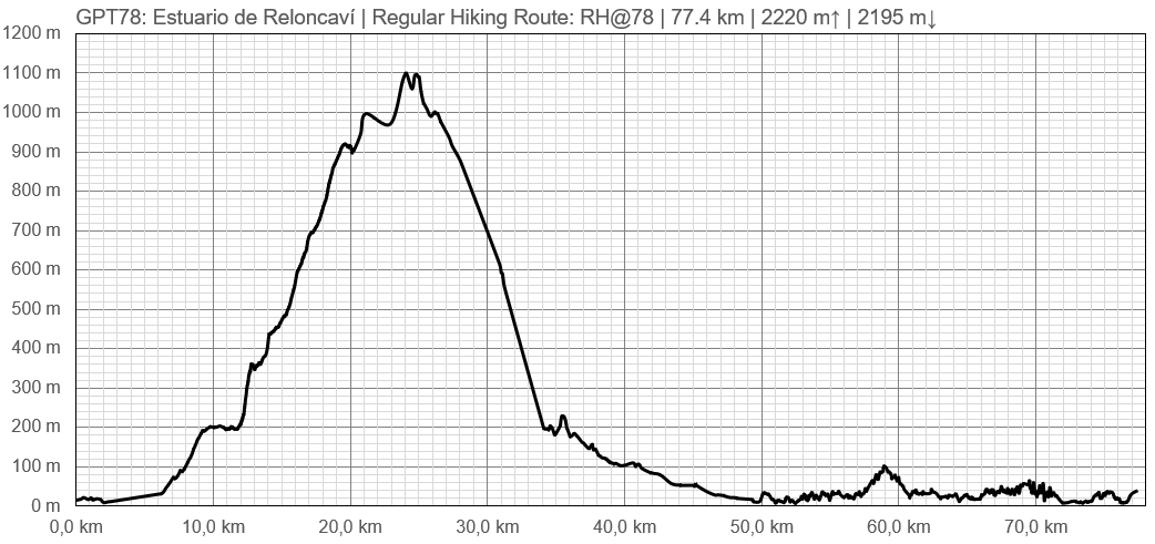
| GPT78: Estuario de Reloncaví | Hiking | Packrafting | |||||
| Group | N: Fiordos Norte | Total | 77.4 km | 33 h | 126.1 km | 36 h | |
| Region | Chile: Los Lagos (X) | Trails (TL) | 11.5 km | 14.9% | - | - | |
| Start | Hornopirén | Minor Roads (MR) | 21.7 km | 28.1% | 0.8 km | 0.6% | |
| Finish | Cochamó | Primary Roads (PR) | 30.2 km | 39.1% | - | - | |
| Status | Published & Verified | Cross-Country (CC) | - | - | - | - | |
| Traversable | Sep - May | Bush-Bashing (BB) | 13.9 km | 18.0% | - | - | |
| Packraft | Very Useful | Ferry (FY) | - | - | - | - | |
| Connects to | GPT21, GPT22, GPT77 | Investigation (I) | (15.1 km) | (19.5%) | - | - | |
| Options | 187 km (2 Options & Variants) | Exploration (EXP) | (15.1 km) | (19.5%) | - | - | |
| Hiking | Packrafting | Total on Water | 125.3 km | 99.4% | |||
| Attraction | 3 (of 5) | 4 (of 5) | River (RI) | - | - | ||
| Difficulty | 5 (of 5) | 5 (of 5) | Lake (LK) | - | - | ||
| Direction | Both ↓↑ | Both ↓↑ | Fjord (FJ) | 125.3 km | 99.4% | ||
| Comment | Hiking: Exploration route | ||||||
| Character | Packrafting: ↑ Preferable due to predominant wind direction | ||||||
| Challenges | Valdivian Rain Forest, Sea Coast, Farmland, Settlers, Fjord Packrafting, Road Walking | ||||||


