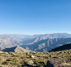
GPT01 - Cerro Purgatorio
|
|
| |||||||||||||||||||||||||||||||||||||||||||||||||||||
Recent Alerts and Suggestions
- 2019-Nov-27 / Family Size
Locked gate with barbed wire (S 33° 36.795', W 070° 30.049') on the official route. Found someone at the gate up the road (S 33° 36.702', W 070° 29.640') who unlocked that one for me. He said the road behind is no private property, but it's always locked. After another gate (S 33° 37.141', W 070° 29.927'), with a hole on the right to climb climb through, this road connects back to the official route. There is plenty of water on the B alternet uphill. Almost at the top it tastes a bit like cow shit after filtering. There is a lot of OK water at the bottom of the downhill and quite a few tourists especially on weekends.
- 2019-Nov-09 / Martina & Ivo
We went to Puente Alto and then Pirque by Uber. The drivers know where the protests take place and avoid those areas or areas which got recently destroyed.
- 2019-Oct-27 / Jan Dudeck
The Metro line 4 to Puente Alto is currently out of operation due to vandalism during the current protests. Check online for current the status and delete this alert once metro operation to Puente Alto resumes.
- 2018-Dec-16 / Martin Lizondo / Regular Route Southbound
Carry plenty of water on this section as water sources might dry out in early summer after all snow has molten.
Puente Alto is not particular safe area of Santiago, so residents recommend not walking very early in the morning or at night through this outskirt of Santiago.
Old entrance of regular route is closed by gate (S33° 37.320' W70° 32.182'). Better start from the public minor road and you won't have any problem (S33° 36.768' W70° 30.033'). The GPT Track File 2019 incorporates this change so follow the Regular Route if you use the current update.
Carry as much water as possible just before ascending to the pass (S33° 38.394' W70° 27.191'). There won't be water until 14 km further, and it's not of good quality (S33° 41.000' W70° 23.100').
Instead of deviating to El Melocotón, you can spend the night in Reserva Coyanco (camping, food, services), from where GPT02 starts. Just turn right at S33° 40.813' W70° 20.812'.
Season Section Log
- 2019-Nov-11 Martina & Ivo
Regular route southbound. It took us 3 days as we started late in Santiago and arrived early in Melocoton. As it's still low season everything is shut down in Melocoton so we took the bus (which runs every 30 minutes) to San Alfonso, where we found nice cabañas and three small resupply tiendas.
- 2019-Nov-17 / Matus & Anna
We walked GPT01 in 2 days, including one nero day. We used uber to get to the trail, hope your driver won't be stupid enough to take shortcuts through slums :). There is a gate on the beginning of trail, after a "discussion" (we don't speak spanish) they let us go through. Climb was really hot, make sure you take enough water from the last source on the way up. There is water on the other side, but first marked water source didn't look the best. There is a river cutting a trail a bit down from that point. We stayed in a campsite on the begining of next section which was nice. They have really sticky ferral dogs there which we had a real problem to chase to not hike with us.
Summary Table
Satellite Image Map
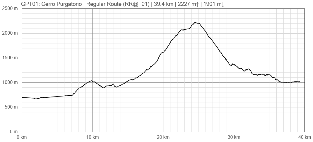
Elevation Profile
Section Planning Status
The regular route and most options have been hiked and recorded by various hikers in recent years and feedbacks are incorporated in the track files. (2019)
Recommended Travel Period
Regular Route: The relative northern latitude and the maximum elevation of 2200 m should make remaining snow less of an issue in spring. Also no major river crossings are required on the regular route. Therefore this section should be traversable from early spring till late autumn. In spring parts of the route might be muddy due to snow melt. During winter heavy snow fall may occur in the elevated areas. (2019)
Option 1 Rio Clarillo: This option links GPT01 directly with GPT02 and is expected to open up later than the regular route due to its higher elevation. See the Recommended Travel Period of GPT02 for further information to this option. (2019)
Benefits of Hiking and Packrafting
This section does not incorporate any packrafting. This would make packrafting gear an annoying burden on the very steep ascents and descents of this section. (2019)
Recommended Travel Direction
Regular Route: The regular route can be hiked in either direction. (2019)
Option 1 Río Clarillo: This options traverses the Reserva Nacional Rio Clarillo. When hiking southbound CONAF park rangers at the entrance near Pirque might not permit a traverse and insist that all hikers return on the same route. But when hiking northbound the Reserva Nacional Rio Clarillo is entered in a sector not monitored by CONAF. Leaving the Reserva Nacional at the entrance near Pirque will not be an issue therefore GPT01 Option 1 is currently recommended in northbound direction only. Combined with GPT02 this option is probably the more attractive finish for northbound hikers. (2019)
Hikers that took this option and have a good command of Spanish might talk to the CONAF park rangers and outline hike. This might facilitate acceptance by CONAF park rangers for southbound traverses of this attractive option. (2019)
Section Length and Travel Duration
Regular Route: The 40 km short regular route can be hiked in two demanding days or three more relaxed days. (2019)
Option 1 Rio Clarillo: This sections links directly with GPT02. See Section Length and Travel Duration of GPT02 for information to this subject. (2019)
Northbound hikers should avoid walking into Santiago in the late evening and either take a bus to the metro station Puente Alto or spend the last night in the mountains before walking into the populated areas of Santiago. (2019)
Suitable Section Combinations
Section Attractiveness
Regular Route: The regular route leads quickly out of the bustling capital Santiago and follows mostly a barely used minor road that was build for the construction and maintenance of an underground gas pipeline. This section is certainly not a highlight of the GPT but a worthwhile start. Especially hikers that advocate connecting footsteps will appreciate that you can walk in two or three hours straight from a busy subway station into the quite Precordillera. (2019)
Option 1 Rio Clarillo: For northbound hikers this option is probably the more attractive choice to finish their endeavour on the GPT. (2019)
Section Difficulty
Regular Route: The regular route requires a long, very steep ascent and descent that are physically demanding. But apart from this no mayor difficulties, technical challenges and dangers are known. (2019)
Option 1 Rio Clarillo: This sections links directly with GPT02. See Section Difficulty of GPT02 for information to this subject. (2019)
Resupply
Resupply Town: Santiago
What you can't source in Santiago you probably don't get anywhere else in Chile. (2019)
Shopping: Food
If you want to prepare resupply packages with dehydrated food items you may find a reasonable good collection of imported products at the Jumbo Costanera Center that is conveniently located at the metro station Los Leones. But such resupply food packages are not really required as there are plenty of resupply towns along the GPT.
Shopping: Fuel
Gas canisters are widely available in large supermarkets, in "fereterias" and department stores.
Shopping: Equipment
See the Wikiexplora page Tiendas_de_equipo_outdoor_de_Chile.
Services: Restaurants
Services: Laundry
Services: ATM and Money Exchange
Accommodation: Hostals and Hotels
Accommodation: Apartments and Cabañas
Accommodation: Camping
Transport: Buses, Taxis and Fletes
Transport: Ferries
Not applicable.
Transport: Shipping Services
You find many offices of Starken and Chile Express all over Santiago.
Resupply on the Trail
There are no known resupply possibilities along the route between leaving the suburb Puente Alto and El Melocoton. (2019)
Access to Route and Return
Access to Start: Santiago, Metro Puente Alto
Plaza De Puente Alto is an underground metro station and the southern terminal station of Line 4 of the Santiago Metro network. Underground trains run frequently between 6 am in the morning and 11 pm in the evening.
Calculate 1 hour from the city centre to the terminal station Puente Alto.
From Plaza De Puente Alto buses leave to most towns and villages in the Maipo valley and the surrounding area. (2019)
Access to Alternative Start: Reserva Nacional Rio Clarillo
From Plaza De Puente Alto the following buses get you close to Reserva Nacional Rio Clarillo:
- Bus 978 towards Rio Clarillo
- Bus MB-74 towards El Principal De Pirque
- Bus MB-80 towards El Principal De Pirque
Buses are frequent and calculate 1 hour for the bus ride. (2019)
Return from Finish: El Melocoton
From Plaza De Puente Alto the following bus gets you to El Melocoton in the Maipo valley.
- Bus MB-72B
Buses are frequent and calculate a bit over 1 hour for the bus ride. (2019)
Escape Options
None.
Permits, Entry Fees, Right-of-Way Issues
Regular Route: No permit or entry fees apply to the regular route. Also no right-of-way issues were reported from hikers in recent years. (2019)
Option 1 Rio Clarillo: Access into Reserva Nacional Rio Clarillo is controlled by CONAF at the main entrance near Pirque. The park is intended for daytime visits only and does not provide camp grounds. Cooking inside the park is strictly banned including with camping stoves. A maximum of 800 persons are permitted entry on one day. CONAF park rangers might not permit a southbound traverse and all visitors are probably required to leave the park in the evening at the main gate. The entrance fee is 6000 CLP for foreign nationals and 2000 to 4000 CLP for Chileans.
A northbound traverse is probably free of charge. (2019)
See also: http://www.conaf.cl/parques/reserva-nacional-rio-clarillo/
Regular Route
Regular Hiking Route
Elevation Profile of Regular Hiking Route
Comments to Regular Hiking Route
To be issued.
Regular Packrafting Route
This section does not incorporate any packrafting therefore the Regular Packrafting Route is identical with Regular Hiking Route. (2019)
Optional Routes
GPT01 Option 1 Rio Clarillo
To be issued.
GPT01 Option 2 Rio Maipo
To be issued.
Investigations and Explorations
The regular route and relevant options have been hiked and recorded in recent years. No significant investigation or exploration tasks remain open. (2019)
Links to other Resources
Related Routes on Wikiexplora
Regular Route
Option 1 Rio Clarillo
Blogs and Other Publications
All hikers are welcome to add their personal travel story or to place a link to their personal travel blog in this chapter.
Austin Davis: Blog: GPT Section 1 – Cerro Purgatorio
Gerald Klamer: Blog: Greater Patagonian Trail 1 Santiago-Coya
Alerts and Logs of Past Seasons
| Name or Alias | Start Date | Duration | Direction | Comments |
|---|---|---|---|---|
| Season 2016/17 | ||||
| Gerald Klamer | 2017 Early January | - | Southbound | GPT01 Option 1 Rio Clarillo connected directly to GPT02 without resupply |
| Bethany Hughes, Lauren Reed | 2017 February | - | Northbound | GPT02 connected directly with GPT01 Option 1 Rio Clarillo without resupply |
| Season 2018/19 | ||||
| Martin Morlog | 2018-10-16 | 2 days | Southbound | Regular Route |
| Austin Davis | 2018-12-15 | 1.5 days | Southbound | Regular Route |
| Martin Lizondo | 2018-12-16 | 1 day | Southbound | Regular Route |


