Diferencia entre revisiones de «GPT14 - Volcán Sollipulli»
De Wikiexplora
(→Elevation Profile of Regular Packrafting Route) |
(→Basic statistics) |
||
| Línea 27: | Línea 27: | ||
==Basic statistics== | ==Basic statistics== | ||
{| border="1" style="border-collapse:collapse" | {| border="1" style="border-collapse:collapse" | ||
| − | |+'''''' | + | |+'''GPT14: Volcán Sollipulli''' |
|style="background-color:#bfbfbf;"|Traversable | |style="background-color:#bfbfbf;"|Traversable | ||
| − | |colspan="2"| | + | |colspan="2"|Dec - Apr (Conditionally: Oct, Nov, May) |
|- | |- | ||
|style="background-color:#bfbfbf;"|Packraft | |style="background-color:#bfbfbf;"|Packraft | ||
| − | |colspan="2"| | + | |colspan="2"|Useful (6.1 km | 6.1 % on Water) |
|- | |- | ||
|style="background-color:#bfbfbf;"| | |style="background-color:#bfbfbf;"| | ||
| Línea 39: | Línea 39: | ||
|- | |- | ||
|style="background-color:#bfbfbf;"|Attraction | |style="background-color:#bfbfbf;"|Attraction | ||
| − | |||
| − | |||
| − | |||
| − | |||
|style="background-color:#ffbfbf;"| 2 / 5 | |style="background-color:#ffbfbf;"| 2 / 5 | ||
|style="background-color:#c2edfc;"| 3 / 5 | |style="background-color:#c2edfc;"| 3 / 5 | ||
|- | |- | ||
| − | |style="background-color:#bfbfbf;"| | + | |style="background-color:#bfbfbf;"|Difficulty |
|style="background-color:#ffbfbf;"| 2 / 5 | |style="background-color:#ffbfbf;"| 2 / 5 | ||
|style="background-color:#c2edfc;"| 2 / 5 | |style="background-color:#c2edfc;"| 2 / 5 | ||
|- | |- | ||
| − | |style="background-color:#bfbfbf;"| | + | |style="background-color:#bfbfbf;"|Distance |
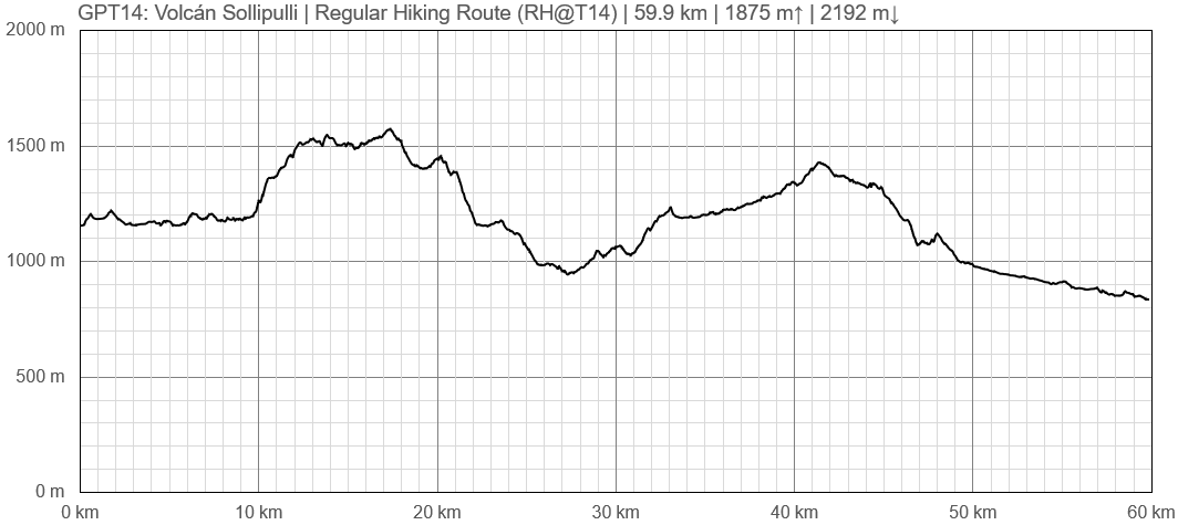
|style="background-color:#ffbfbf;"|59.9 km | 17 h | |style="background-color:#ffbfbf;"|59.9 km | 17 h | ||
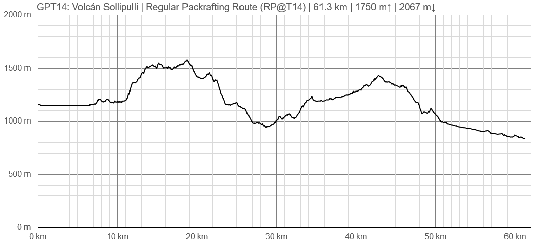
|style="background-color:#c2edfc;"|61.3 km | 18 h | |style="background-color:#c2edfc;"|61.3 km | 18 h | ||
| + | |- | ||
| + | |style="background-color:#bfbfbf;"|Direction | ||
| + | |style="background-color:#ffbfbf;"|Both ↓↑ | ||
| + | |style="background-color:#c2edfc;"|Both ↓↑ | ||
|- | |- | ||
|style="background-color:#bfbfbf;"|Comment | |style="background-color:#bfbfbf;"|Comment | ||
| − | |colspan="2"| | + | |colspan="2"|- |
|- | |- | ||
|style="background-color:#bfbfbf;"|Status | |style="background-color:#bfbfbf;"|Status | ||
| − | |colspan="2"| | + | |colspan="2"|Published and Verified |
|- | |- | ||
|style="background-color:#bfbfbf;"|Zone | |style="background-color:#bfbfbf;"|Zone | ||
| − | |colspan="2"| | + | |colspan="2"|C: Zona Pehuenche |
|- | |- | ||
|style="background-color:#bfbfbf;"|Region | |style="background-color:#bfbfbf;"|Region | ||
| − | |colspan="2"| | + | |colspan="2"|Chile: Araucanía (IX) |
|- | |- | ||
|style="background-color:#bfbfbf;"|Start | |style="background-color:#bfbfbf;"|Start | ||
| − | |colspan="2"| | + | |colspan="2"|Icalma |
|- | |- | ||
|style="background-color:#bfbfbf;"|Finish | |style="background-color:#bfbfbf;"|Finish | ||
| − | |colspan="2"| | + | |colspan="2"|Reigolil |
|- | |- | ||
|style="background-color:#bfbfbf;"|Previous Section | |style="background-color:#bfbfbf;"|Previous Section | ||
| Línea 76: | Línea 76: | ||
|style="background-color:#bfbfbf;"|Alternative Section | |style="background-color:#bfbfbf;"|Alternative Section | ||
|- | |- | ||
| − | |[[ | + | |[[GPT13]] |
| − | |[[ | + | |[[GPT15]] |
| − | | | + | |No |
|} | |} | ||
| + | |||
==Section Planning Status== | ==Section Planning Status== | ||
==Recommended Travel Period== | ==Recommended Travel Period== | ||
Revisión del 13:44 26 mar 2019
This article is just a draft. You can help by expanding and improving its content
|
| ||||||||||||||||||||||||||||||||||||||||||||||||||||
Section Statistics
Basic statistics
| Traversable | Dec - Apr (Conditionally: Oct, Nov, May) | |
| Packraft | Useful (6.1 km | 6.1 % on Water) | |
| Hiking | Packrafting | |
| Attraction | 2 / 5 | 3 / 5 |
| Difficulty | 2 / 5 | 2 / 5 |
| Distance | 59.9 km | 17 h | 61.3 km | 18 h |
| Direction | Both ↓↑ | Both ↓↑ |
| Comment | - | |
| Status | Published and Verified | |
| Zone | C: Zona Pehuenche | |
| Region | Chile: Araucanía (IX) | |
| Start | Icalma | |
| Finish | Reigolil | |
| Previous Section | Next Section | Alternative Section |
| GPT13 | GPT15 | No |


