GPT15 (Curarrehue)
Contenido
[ocultar]How to a add new entry
You need to be logged in to save your edits (and on mobile view, you need to be logged in to start editing).
Add a new log entry always on top in the appropriate season sub-chapter and use format:
* '''Start Date to Finish Date (use Format YYYY-MMM-DD) / Duration in Days / Hiking or Packrafting / Travel Direction (SOBO for Southbound or NOBO Northbound) / Chosen Route and/or Option Name (RR for Regular Route) / Names or Alias'''
Include remarks about your route useful for other hikers and packrafters, alerts, suggestions and personal perception of attractiveness and difficulties. Try to be specific. Do not be shy to fix obvious mistakes.
Overview
Section Log, Alerts and Suggestions
Season 2025/26
Season 2024/25
- 2025-Feb-10 to 2025-Feb-14 / 2 days / Hiking / SOBO / RR / Farah & Jan
Combined GPT14 and 15 and took 6,5 hiking days in total including the Sollipulli Summit ascent.
Highlights: Araucaria forests, Piñones, fast food, hospitable Mapuches, delicious blackberries “Challenges”: Fallen trees and spinous blackberry bushes
Planned to spend our first night on GPT15 at Camp $ {15} [2.4+0.2/819]. Upon arrival we only found a deserted property with an empty house. Augusto, the neighbor at S 39°08.1453’ W 71°28.9760’ told us that the owner wasn’t at home but we could camp there anyways. Few minutes later his daughter Gloria offered us to sleep in a bed in a house on their property house for 20 luca. We happily accepted and got ice cold watermelon and some savory empanadas for second dinner - a stroke of luck after the restaurant in Reigolil was closed.
In the morning Gloria made a delicious breakfast for us, consisting of huevos revueltos, pan, ají, manjar casero and mate. We gave her 20 luca for the bed and another 20 for the two meals.
Augusto showed us a small cabaña he is currently building to host more hikers in the future. After using the power supply and internet for some planning and communication, we continued our hike in the afternoon.
At around S 39°11.0510’ W 71°28.0804’ we met a guy called Roky who offered us accommodation. We declined but noted his phone number for hikers who pass there in the future: +56 9 7820 4656
At S 39°13.0879’ W 71°26.1168’ we discovered a food truck just 200 m across the bridge from the RR. We ate one serving of delicious fried chicken, one of salchipapas and two soft drinks for a total of 11 luca. The owner told us he had opened this year.
Camped at S 39°15.0309’ W 71°25.9345’. Not ideal as it’s very close to the street but at least next to the river.
The next morning we ascended to Laguna Hualalafquén and spent one and a half days there, enjoying this beautiful place. Along the way we found a brand new mini shop (although closed when we passed it at round 8 in the morning) at S 39°17.8526’ W 71°26.0645’. Also picked a lot of delicious blackberries on our ascent.
On our second day at the laguna, we met fellow GPT hiker Peggy who pitched her tent close to ours and we had a nice chat with her.
Started early in the morning the next day to walk to Curarrehue. Filled out water bladders at the laguna which would not have been necessary as there is plenty of water on the way down.
Plenty of fallen trees that had to be climbed over or crawled under slowed us down on the way down. Got caught in blackberry bushes with nasty spines. Also found another locked gate which was super easy to climb around though.
From Curarrehue we originally wanted to take the next bus to Pucón (they go every 30 min), but then decided to stay a night and then even one more as this little town/village is very beautiful. Strongly recommended for hikers who want to take some time to explore a community where Mapuche culture is lived and celebrated.
- 2025-02-11 / 1 day / Hiking / SOBO / Road+OH 15A+RR / Dorota Szparaga
I followed the advice of the owner of the hostel and took the road which is parallel to the RR. Nice, comfortable road with a lot of houses. He said that here there are fewer cars. There were "zona de carpas" at points -39.23382, -71.43492. In the settlement Maite Aquas Blancas (15-A) [4.2+0.5/526] I crossed the bridge and joined at km 4 var A. There was water at -39.34382, -71.49513. Quiet road in the forest without views. Then I took the RR from km 40.9 of the RR. Night at Curarrehue en Cabana together with Peggy ( she went from stage 16). We paid 50.000 clp. To rooms and salón and kitchen (-39.36245, -71.58551). The village has everything. A lot of supermercados, ferreteria (gaz) -39.36469, -71.58380. Also, you can repair your clothes in two places. One -39.36170, -71.58498. Another at -39.36358, -71.58413. Also, there is a man who can repair shoes, his phone +56961763003.
- 2025-01-15 to 2025-01-16 / 1.5 days / NOBO / RR + Option 1 (PN Huerquehue) / Tobias
Arrived at PN Hierquehue with the first Bus from Pucon in the Morning. Could not enter, because the Tickets for the Park were sold out and they didn’t let me cross the park anyway. No one with a big backpack was allowed to enter. Ranger said, that the path to the other side is closed since 9 years. Thought about finding my way around the checkpoint, but there is another checkpoint in the Park and I don’t won’t to complain, so I turned back and hitchhiked to Currarehue. There is a second unofficial entrance to cross Huerquehue down from the lake (-39.11001, -71.74589). I have done that trail 5 years ago and it worked. But to get there you need to do another 20km road walk by the lake.
From Curarruehue I walked on the boring road. Good thing about walking boring section is that I always meet a lot of people. I was 3 times invited for coffee or mate, ate many cherrys and learned a lot about the Mapuche communities up there. I did not hitchhike, but 2 cars stopped beside me and took me for a while. So all in all, I liked the section.
- 2025-JAN-04 / 1 jours / Randonnée + bus / SOBO / RR / Pierre-Marie
Etape : GPT14+GPT15+GPT16+GPT17+GPT18+GPT19 | Meteo : soleil | Eau : facile | Neige : non | Intérêt : 1/5 | Difficulté : 0/5 | Danger : aucun
Bus a 7h45 Reigolil > Maite Centre (km 24,1). Du km 39 au km 41, le sentier n'est plus utilisé par les locaux et la végétation pousse vite. Dans la vallée tout est cloturé, j'ai ouvert le portail au km 41,5 pour prendre de l'eau. La gravel road jusqu'a Curarrehue est arborée et se fait bien.
- 2024-DEC-31 to 2025-JAN-02/ 1,5 days / Hiking / SOBO / RR + OH (var. A) / Ivan, Jakub, Daniel
A gravel section, mostly flat, that felt more like a connecting stretch leading to Curarrehue.
In Reigolil, we resupplied in the evening and walked a few kilometers past the village, where we camped by the river. We spent a peaceful evening by the fire with bottles of wine, marking the last night of 2024. The next morning, we took our time and then started tackling relatively monotonous gravel sections.
At the Maite Centro crossroads X {15} [24.1/544], we deviated from the RR route and chose variant {15-A}. Shortly after, we came across a brand-new and well-stocked shop that wasn’t listed in the track files (coordinates: -39.29747, -71.43439).
At the crossroads X {15} [41.5/719], we rejoined the RR route and followed the well-trodden MR path all the way to Curarrehue. This is a great place to resupply, and we even managed to find a gas cartridge at the hardware store located at the end of town (-39.3547505, -71.5930750).
- December 17–26 2024 / 10 days/ Packrafting / SOBO / New option combining Huella Andina and nearby lakes from Icalma/Villa Pehuenia to Paso Mamuil Mamal (road from Pucón to Argentina) GPT14 RP?, GPT15-RP???
See our full report on wikiexplora page for GPT 14 for Argentinian packrafting version of GPT15.
- 19Dec2024 - 20dec2024 / hiking / OH1 (after GPT14 SOBO) / 2 days / Clara
Nice way to go out of section 14. Sleep at hospedaje Verónica on OH1a
Road for few km, hitchhike a part but not much cars. Then trail (to go on, need to enter a private property. There is a gate that is not close few meter after the tracks on map). Go back directly on tracks neither it's rapidly BB. Trail throught a dense forest but very well maintained.
Lake isolda : impossible to camp here cause very dense vegetation and marsh around the lake. Few km further there are 2 glades where it's possible to camp with river flowing around. After lake, path is a bit less maintened and overgrown but still really easy to follow. After few km of trail, you arrive on an old road where cars can't go anymore for sure, easy walking till termas de rio blanco. Some nice views on the valley and montains around but most of time forest hiking. Multiple gates easy to go throught. 2 nice saltos (indicated) before termas de rio blanco where would bu nice to swim if hot weather.
Camp eco termas (15k for night + enjoy termas really hot and nice).
Day 2 is mostly trail in forest. Some nice views when up and on the other side on the lake and the villarrica volcan. 2 waterfalls. Up the trail, lago toro (west side), lago verde and lago chico have nice place where you can eat/rest. Then lake tinquilco, many campings, cabañas, restaurant. Conaf there between 8.30-18.30 and theoretically need ticket to go to the national park. Also it's written that path to rio Blanco is closed so maybe it's wouldn't be possible to go in the other way. There were no one when I passed, end of afternoon so they didn't asked me where I came from.
From there, easy to hitchhike to Pucón.
- 2024-dec-08 to 2024-dec-10 / 2.5 Days / Hiking / SOBO / RR / Karin
Camp: km14 improvised (read text)/ km30.6
From the village Reigolil to Maite, there are not real possibilities to camp. I was lucky and disovered a improvised place about 3.3km after GPT15-03 Start on the left side of the road, in a little forest, just before the paserelle, at the woodworker. A small stream is there too. It was ok for one night, but not optimal. There is space just for a one person tent between the trees. As it was Saturday nobody was there.
The gravel road and the trail to the Laguna km30.6 is easy to follow. As the Laguna is quite flat at the border (high water level), the water was lukewarm and nice to take a bath.
The way down to Settlement km40.9 was sometimes overgrown, or blocked by fallen trees/brunches. From the moment the path gets on the wider "road" (about km39), I would suggest to continue on this "road" (which joins var A) and not to turn left, as this path is not maintained at all and will soon be impossible to walk.
Curarrehue is a bigger town in the mountain, so there is all kinds of shops for resupply and accomodation.
- 2024 nov 14 / 1 day/ hiking/ Sobo/ RR/ Allie
I took the bus from reigolil (at the bridge by the river) to maio centro. From there i started the ascent to lago hualalafquen. Its very straightforward. From the lake to currarehue its easier to lose the trail and lthere are some large tree trunks to climb, but no real obstacles.
- 2024 nov 5.-8. / 4 days of hiking SOBO / Option PN Huerquehue / Daina and Arno
We did a combination of GPT 14 & 15 and took the option through the NP Huerquehue. Day 1 was GPT 14. Note: we didn't have the files.
Day 2
Almost no traffic at the minor road, but still boring for a hiker.
At -39.069326, -71.536092 there is a locked gate with a good trail, which leads directly to the shore of Laguna Isolda. But we couldn't find a connection to the trail to the Thermas.
The log entrys says the correct trail to Laguna Isolda is in good condition, so i assumed it will be easy to find the trail to Laguna Isolda, without knowing the exact position of it. I was totally wrong! I had marked a spot on the map where it could be, but there were two gates very near, both easy to open. We tried 3 different paths, but they all disappeared quickly. After more than one hour of searching, we hiked back to a trail which leads to Laguna Cochor to spend the night. Both sides of the road are fenced with barbed wire. Very difficult to find campspots.
Day 3
At -39.069326, -71.536092 there is a locked gate with a good trail, which leads directly to the shore of Laguna Isolda. But we couldn't find a connection to the trail to the Thermas. Here the path near the shoreline was very overgrown, until we couldn't find it anymore. We backtracked to the road and lost 3 hours. Frustrated we walked 15km to the Thermas on the road. No cars in our direction, no possibility to hitch.
The trail to Camping Renahue at the right side was overall in ok condition. We didn't see the left trail. The lower part was very wet due to snowmelt. The steep part was muddy, but without obstacles. May be demanding on a rainy day. Later there were a lot of huge fallen trees on the path, we followed horse tracks. They lead around the blowdowns. 7:15pm we arrived at Camping Renahue. There and at the beginning of the trail we couldn't find signs about a trail closure.
Day 4
We choosed the trail down to the Laguna Carburgua to avoid the Conaf. The condition was good, can't complain about it. The roadwalk until the primary road was annoying, again no car in our direction.
Season 2023/24
- 2024 Mar 31st to Apr 5th / 4 hiking days / SOBO / Hiking / Opt 1 / Michael and Kasia
We did sections 14 and 15 together.
TL:DR: Opt 1 is a nice route with lots of forest walking and some termales options; the Renahue sector of PN Huerquehue is still closed, but that also means no one is there.
Day 1 Mar 31st
Our hitch dropped us off at the beginning Opt 1. It is a road walk, but the road is not much used, so it wasn't too bad.
We camped at (-39.06732, -71.51559) just before the bridge. It was a functional campsite. It was right next to the road and the ground was covered in a thin layer of pumice, so not optimal for the tent. But it was flat, and didn't require climbing any fences. Going back a small path it had good river access. It was also clearly used as a campsite by other people. There was a fire ring and a grill hanging in a tree.
Day 2 Apr 1st
We continued on the road. We passed the entrance to Opt 1B, though we didn't have time to take it. It is a clearly marked trailhead. We continued on the road to the private property. We tried calling the phone number on the private property sign, but no one answered so we decided to just go ahead. The entrance was through a barbed wire gate, then follow the path along the fence line to the trail. The trail was in pretty good shape except for a few areas where water has rutted it out. We did not find any real access to Laguna Isolada; there was a ring of marsh grass about 3 or 4 meters wide around the whole lake. Where the track gets closest to the lake there was a fallen tree that we sat on for coffee and lunch. At two points there were fairly elaborate wooden barricades, one that we climbed under, the other we climbed around. It was unclear whether they were for animals or people. As has been noted before, the road begins earlier than it shows on the map. We did not see anyone the entire time. We both really enjoy walking in the forest, and the forest was very pretty throughout the day, so we were happy we chose to go this way instead of just hitching all the way to the termas.
We arrived at the termas area. Eco termas seemed nicer than San Sebastian. The weather forecast was predicting heavy rain and wind up to 60kmph with gusts over 100 kmph the following day, so we wanted to stay in a cabaña instead of the tent and neither of the termales places could accommodate us. We found a cabaña at Cabañas Rio Blanco (-39.10593, -71.61558). It had a well equipped kitchen, wood stove with wood included, and hot water in the shower and sinks. The woman who runs it, Angélica, was incredibly nice and made excellent pan amasado. There is no cell service in the valley and power cuts are a daily thing, though there was power for several hours a day, so plenty of time to charge things.
Day 3 and 4 April 2nd and 3rd
We stayed at Cabañas Rio Blanco for two days to wait over the weather.
Day 5 April 4th
We left Rio Blanco and started up the trail to PN Huerquehue. The trail was in decent shape, better than we had expected. Along the way we saw a lot of different mushrooms, including some very impressive groups of Amanita muscaria that were so shiny red they almost looked fake. At the Letrero mark on OSM is the welcome sign. There was a laminated piece of paper stapled to it that was so badly faded from water as to be unreadable. If it weren't for Natalie's note from last year we would have had no idea what it said. The Renahue sector is still officially closed, as is the camping. The trail up was sometimes a little hard to keep track of. It was also pretty slippery for a lot of it. I would definitely not recommend doing it in the rain. The forest is pretty though and we really enjoyed the hike. We camped at Renahue. It was fine, though nothing special.
Day 6 April 5th
From Renahue we followed the trail toward the entrance. Until Laguna Huerquehue there were still a lot of blow downs to climb over. In some places it looked like recent maintenance had been done, in others not. Laguna Avutardas is a short detour, as is Laguna Huerquehue which is less a laguna and more of a wetland. Laguna Toro was pretty and we stopped there for lunch. There is a campsite marked there on OSM, however the ground was saturated, not sure if from the rain or from the lake, but not a good camp spot. Lago Verde and Lago Chico were also nice. The trail after Lago Chico was in pretty rough shape. It was clear and there was no brush, but it was very wet and extremely slippery. There was no one at the ticket office when we left, however that is not really the exit. There is still more than a km of trail until a road, and then another 2 km until the actual gate. It was about 7:30 and we were about 200 m from the main entrance when a CONAF guard drove up in a truck, on his way to his house I assume. It ended up being a somewhat uncomfortable conversation, he was upset that we had gone that way and he said a number of things that didn't make sense, but the essence was that it was prohibited to cross the park from Rio Blanco. After everything he was a bit more demure and said if we wanted to camp at the CONAF camping it was 20.000 and we could register and pay in the morning, then he left. We were considering camping but a truck was leaving the entrance right as we got there and we caught a lucky hitch all the way to Pucón.
- 2024-03-09 // 1 day // Hiking // NOBO // OPT3 + RR // Quentin Clavel
As the weather was not on my side this week, and that I've got only one sunny day, I did my best to have this nice day for the ascent of the sollipulli volcano.
So I decided to shortcut this GPT15, by passing threw the vallee Panqui (OPT3). It was not a very attractive section, as the RR I guess, rated 1/5 in terms of attractivity. But it was nor terrible !
After the city of Currarehue, you just follow a long and boring gravel road all along the vallee Panqui. Most surprising moment was to meet the polish priest of the city of Currarehue (yes, you read well), that really wanted to speak and know more on my adventure. After long discussions he even pried for me to have a safe end of my trip, and admit some doubt to have a track at the end of the gravel road. Another wtf moment of this GPT.
The priest was wrong, of course there were a track at the end of the valley ! And I was happy about that because I was quite bored about this gravel. Track is easy to follow, again more when you pass after cross-country motorcycle that made the way again more easy to follow !
Best little moment of this section was the view on the pass, af the valley and the sollipulli volcano far away.
Then you go down and continue the section until reigolil on a gravel road. People down there were very friendly and quite surprised to see me, not sure there's a lot of hikers who are passing threw the area !
Reigolil is tiny tiny, not the best choice to resupply, but there's a minimarket in case of emergency.
- 2024-Feb-14 to 2024-Feb-16 / 2,5 days / Hiking / NOBO / RR / czimahi
from Curarrehue by road, no prob, first drinkable water just before Puesto 15 [37.4/1101] one spiny fence on the way like on S39°22.000` W71°29.557` but you can just follow the road and then there is another road up. I slept like 0,5km before Puesto 15 [33.1/1096] with water The rest to Reigolil no prob, road ripio, I slept just after bridge Quinenahuin in some abandoned terrain
- 2024-Jan-15 to 2024-Jan-16 / 1.5 days / Hiking / SOBO / RR - {15-03} / Lilian
Km1.07 : camping possibilities at west of the road(without fence)beside the river, some trees for privacy and cover.
Km4.0 : Dirt road junction, you can follow the dirt road to river side, looks like a large flat area there.
Km4.85 : large and beautiful grassland with trees and beside the river, some camping trace here. A small stream is flowing across the road 50m more.
Km7.8 : I crossed to the other side of valley with a bridge at here.
Settlement[59.8+6.9/767] : also a small shop here, selling some food and drinks, not much selection but good stock. I saw some locals waiting bus at here too. Super friendly.
Then i continued south to join {15-03}.
{15-03} km1.45 : i saw a clear trailhead going south at here.
Km1.6 : junction of road and trail.
From here to km4.1, {15-03} is a very old, damaged and no more cars running dirt road. Mostly you are following it, walking on it or some horse trail and cow paths to the pass at km4.35. Steep but very easy to follow.
Km1.68 : a trail junction here, it is a very clear trail to north, i think it is connected with the trailhead at km1.45.
Km2.25 : side trail to a stream (-39.19811, -71.47021), some people use wood and bamboo made a pipe here, easy to collect water, thank you!
Km2.75 : beautiful camping spot with grassland.
Km3.1 : small stream(-39.20079, -71.47549) flowing good, easy to collect.
Km3.9 : no more trace of road, become a horse trail. Some flat spots at valley(east) side with views but windy.
The trail is maintained by some people, some sticks just cut off on the ground maybe some weeks before. Trail condition is good and going smooth.
Km4.35 : some flat spots and an old, small bridge here. Stream under the bridge without flowing.
Km5.8 : trail condition becomes an old dirt road, also a dirt road junction here.
Km5.85 : beautiful grassland(-39.21900, -71.48849), with a huge tree can fit lot of tents here. Bridge and a good flow stream nearby(-39.21831, -71.48848).
Km5.9 : bridge, stream flowing good with clear water under the bridge.
Km7.55 : stream flowing low beside the road, cross a log to grassland camping spot. After here, no more camping possibilities i can find.
Km8.1 : a friendly locked gate, easy climb at left side.
Km8.2 : bridge, stream flowing good with clear water under the bridge.
Km11.3 : bus stop at the turning, but i don't know about the bus schedule.
I walked about 4-5km more, a local driver waved hands to me, then i arrived Curarrehue, MAGIC!
Good town for resupply. Lot of accommodation, some supermarkets and restaurants in Curarrehue, also bus to Pucón and Santiago. I resupply at Supermercado Katty(-39.36219, -71.58473), because locals told me it is the best in Curarrehue, and i find 230g gas canisters at GYG Supermercado (2nd floor)(-39.36043, -71.58693), it just left 2.
- 2023-28-12 / 1,5 days / Hiking / NOBO / Option 1 + 1a / Jens
I crossed the Huerquehue National Park to the north. Bus from Pucon to the entrance at 8.30am. Be there early, it fills up quickly.
The warden told me that it was illegal to cross the park because of the trek closure. I assured her that I would come back and ignored her.
The crossing was easy and beautiful. The trail was mostly maintained with the occasional tree trunk to climb over.
Camping and water available.
Season 2022/23
- 2023-Feb-27 / 4 days / Hiking / 15-O1 NOBO + Solipulli traverse + 14 SOBO / Martial
Very nice expedition starting opposite side from Nat & Tomas cause i skipped GPT11-13 for gear resupply in Pucón (Volcanica outdoors very good btw !). Started 15-O1 in Parc Huerquehue the 23 in the morning after negociating an entrance ticket with one of the guard off voices who was very comprehensive after i got here without ticket on the 22 at 18pm and parc was fully reserved for 2 more days.. Be more prepared ! Had a lucky price 10mil for Olga’s camping 10mil for 1 person arriving late. Very good value for money ! Crystal clear lake water sunset, hot clean showers, caring owners.. Beers, galletas y pan amasado caliente in the morning ! Had to get back to the CONAF gate in the morning for ticket so wished i had left the mochila in Olga’s 😓 Easy and nice walk up to the lagunas and although i have been warned Renahue sector was shut, i decided to continue as Conaf is not checking exit route. (The sector has been closed for missbehavior of the visitors so obviously don’t make fire or leave basura !!). Starting this sector the trail is volontary left sufficiently overgrown to discourage normal visitor but no GPT hiker 😄 and the way down to the Termas is nice enough. Stayed at ecotermas for 15mil after nice chat with Richard the guardian. Loved to immerge in the termas for hours with a beer and chating with Chileans. Next morning had in mind to hitchhike but no cars so found nice cascade before turning left to laguna Isolda. The owner put a gate « recinto privado » but you can pass asking for permission.. I bumped into him and his little daughter cleaning the trail to the laguna with machete : very nice guy and thanks to him the trail in this forest till the road is beautiful ! Hitchhiking the road was no better so had to camp next to it on an unmarked camp here -39.06698, -71.51530, rainy night. The day after finally had a lucky hitch all the way to the entrance of the reserva to Solipulli so could actually make it to the summit on the same day by following the south est ascent. It is CC after the treeline and found a good path climbing to the lake located before the crater for high camp (my specialty it seems 😄 !). Aqui : -38.96789, -71.49060. Weather was getting full sun so no problem and was delightly rewarded by one of the most amazing sunset of my life setting just into a depression of the crater above the glaciar. Mesmerizing and got me smiling for hours despite the crazy windy cold ! After an icy night i used the same path to the ridge scouted before and could join the RR and true summit for midtime before going down on the easy north route heading to CONAF. There was surprisingly no-one there on a sunday early afternoon. Got small supplies from the lodge owner (28mil one p. in the refugio so passed and camped near a lake before last ford : recommended). Met also Franklin family for a few welcome asada meat sandwich treat 🍖 So generous !! Next day was big MR hiking back 14 sobo so putted earpods and went fullgas to a camp after Reigolil marked on gaia gps (but actually shut so got it free after asking for permision to the abuelo : -39.13615, -71.48404). Very hot and boring no cars after the reserve exit. Happy to reach Curarrehue’s cafeteria for sweet delights after 07:10 bus !
- 2023-Feb-20 to 2023-Feb-21 / 2 days / Hiking / SOBO / OH 1 PN Huerquehue / Natalie & Tomáš
Hitched from the end of GPT14 to the start of the trail to Laguna Isolda (option 01). The start is gated (easily passable) and says private property but we continued. Sign said to call bosquesnalcahue (45) 91 06 59. We anticipated a bushwack but the trail was in surprisingly good conditions and we managed to meet the women responsible for the upkeep later in the park, she guides horse tours through those trails and clears as much as she can. The trail however is "so so" and you cannot access the lake easily, if you need water there is running water here;-39.10352, -71.54720. The trail turns into a road sooner than it is shown on the map, it turns into a road here;-39.10477, -71.54474 (about 5 km in). The road to the hotsprings has lots of water sources but it is not very interesting and I personally wished I just hitched all the way to the hotsprings to spend more time there. However, there was an interesting deserted logging operation along the way (-39.12617, -71.55411), we learned from the horse guide that the company went bankrupt and just left everything there.
Camping at the hotsprings; Eco Thermas Rio Blanco and San Sebastian, are 15mil/person. We chose to stay at Rio Blanco because of the pools and a better variety of camping spots. We camped above the booth where you pay and the man who we payed showed us a hidden super hot (adjustable with cold water hose) bath not too far from our camp spot. Tomáš was surprised there by a family at 10 PM so keep some makeshift swimsuits ready. Both campings sell some basic food items but not much.
There is a sign saying the trail to Huerquehue is closed "Indefinitely" and so is camping Renahue. Quite alarming but since the website said the park was open we continued with the mindset we would have to turn back. The trail was pretty good from the termas to camping renahue and it is here where we met the horse guides that were doing the trail maintenance near Laguna Isolda. The horse guides came up through the trail from lake Caburgua and they said it was an easy trail. This could be a good option if you wanted to avoid any trouble with CONAF and the section closure. However we were still curious about Huerquehue so we continued option 01 thinking we would turn back if we saw another sign or anything saying the trail was closed, to our surprise there were no more signs. Between camping Renahue to lake Huerquehue, there is a lot of blow down but after lake Huerquehue, the trail is pristine. We started seeing people after Lago Toro, so obviously the park was open. With the combination of having a late morning at the hot springs and all the indecisiveness about closures we ended up walking through the park at a great time (530-7pm). There were very few people and we really got to enjoy how beautiful it was there. CONAF website said they close at 530pm but there are no gates and attendants so no problems leaving the park later. Unfortunately at the lake the camping El Rincon was closed and camping Olga was 18mil a night with a minimum of a two night stay so we managed to get a hitch to Pucón. If needed, you can illegally camp at the CONAF station as that is what others were doing or ask "Alicia" at the old El Rincon campsite if you can pay privately and take care of your washroom needs- supposedly they had to shut down due to washroom problems.
"Trail closure" on option 01PN Huerquehue. When leaving the Eco termas Rio Blanco hot springs there is a sign saying the "Huerquehue trail, camping renahue and the dome" are closed "indefinitely". The park itself is open but supposedly that section on the trail is closed. We continued bcs we were not sure which trail they were exactly talking about but we were prepared to turn around if we saw something blocked off. The trail was fine except for a lot of blow down up until the lake Huerquehue. If you want to avoid this closure there is a trail in good shape coming from lake Caburgua to camping renahue. We met a horse guide coming from there and said it is fine.
Season 2021/22
Season 2020/21
Season 2019/20
- 2020-Feb-05 / 1.5 days / Hiking / SOBO / Frank
I combined GPT15, 16 & 17. It's easy to resupply in Curarrehue & Liquine. 2 short days for GPT15 & continued to GPT16 on 2nd day. Got the bus from Pucon to Reigolil via Currarehue. Didn't go to the lake but continued straight on the main road to Curarrehue. This option is quicker but there are not many places to camp.
- 2020-Feb / 1.5 days / Hiking / NOBO
We took the dirt road on the west side of river. There is a small coffee about 7km from Currarehue. Very nice with good atmosphere. No particular interest in this section. Hitch if you can, there are quite some people living along this road so it should be easy. There is a bus doing Currarehue/Reigolil every day. Currarehue is nice to resupply with restaurants, supermarkets and accommodation. There is also an ATM. Reigolil there is only one very small shop with not much.
- 2020-Jan-30 / SOBO / Main road / Martina & Ivo
We started to walk on the road on the Western side of the river just to see what will happen. After 2 hours a bus to Curarrehue came ;-)
- 2019-Nov-26 / 2 days / Hiking / SOBO / RR / Shaun C
Straightforward. Took a short 2 days. Rained incessantly, but still very pleasant, especially the misty Laguna Hualalafquen. Water readily available throughout. Only a few patches of snow (above 1200m).
- 2020-Jan-15 / 4 days (GPT14 + GPT 15) / Hiking / SOBO / RR / Matus & Anna
We combined sections 14 and 15. It took us 3 days and nero. GPT14 - there are signs that someone tried to clear overgrown part of the trail on the begining and end but middle is still nicely overgrown. Though we didn't have problem to follow. Part of minor road on regular trail is under construction. They are putting a huge pipe under it. It was evening and workers were not there se we managed to sneak through but I don't think they will let you pass during working hours. It's just before descending to the river before National reserve Villarrica. In the Conaf campsite was food truck (it was weekend) with churasco, sopapillas, drinks... pure heaven. We paid 4000 per person at conaf. They are building a dorm at Lodge. It will be ready for next years hikers ;) Resuply in Reigolil - mini shop on trail seemed abandoned. We found best supplies in shop-4. There is one other shop directly after bridge. GPT15 - road and trail in good condition. On the climb to the lake bit before last settler there are some wild cherry trees on the left. We stuffed ourselves and left for others too. Enjoy. Multiple shops, accomodation options and restaurants in Curarrehue.
- 2020-Jan-19 / 1.5 days / Hiking / SOBO / RR / Tom & Maddie
Easy walking, road in good condition. Would recommend hitching if you have limited time, but worth doing otherwise to connect sections 14 and 16. Really good resupply in Curarrehue (restaurants, grocery stores, clothing stores, pharmacy etc).
Resupply and Accommodation
- Pucon has a few big supermarkets & several shops with hiking gear. One of the supermarkets has a hardware section where you can buy camping gas.
- Regioli at the northern start of the section has only one limited shop.
- Curarrehue, at the southern end, is a decent-sized town with numerous restaurants and shops.
Resupply and Accommodation in nearby Towns
Resupply and Accommodation along the Route
Quentin : Currarehue is kind of a big city, where you'll find easily places to resupply (there's at least 4 supermarkets and 10 minimarkets), foodplaces and accomodation (cabanas, hospedaje and hostel (at the end of the city)). Didn't checked in all supermarkets, but there's a good chance to find Gaz in this city I reckon, if not in supermarkets, probably in ferretería ?
Reigolil is tiny tiny, not the best choice to resupply, but there's a minimarket in case of emergency.
Transport to and from Route
Regioli has limited options. Curarrehue is much better connected.
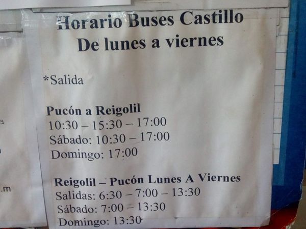
Bus goes from Pucon to Curarrehue then Reigolil
As of January 2024
Bus from Reigolil to Curarrehue at 2pm. 1000 pesos. Two hour bus ride.
November 2024:
Direct bus from Pucón (Terminal Pullman) to Reigolil. 2600 CLP. 10:30 a.m. at a tuesday, but better to ask about the correct time at the terminal, because there is no written information.
SOBO to Parque Huerquehue: Ask the Termas about chartered buses: Whatsapp;+56946809918, +56992318329. Otherwise make your way via Cunco or Temuco-->Cunco. Temuco's Terminal de Buses Rurales (Balmaceda 1475) can be complicated since most buses have their own shop elsewhere. For Cunco go to office "IGI LLAIMA/ Nar Bus"; Balmaceda 997. The bus leaves every 30min.
From Cunco check with locals about bus to Lago Caburga. Supposedly a bus leaves everyday at 4 or 5pm from Balmaceda corner La Concepción. It will pass by the nice supermarket;Supermercado Hesis on "Colico Sur" aka the S-75. Confirm schedule in the municipality of Cunco before traveling at +56 45 2200147.
Hitchhiking is easy up until Lago Collico, after that there are cars but not many stop.
Permits, Entry Fees and Right-of-Way Issues
Links to other Resources
Retired Section Article GPT15 - Curarrehue
Images
