![]()
ENG:Trekking Cerro Castillo

| |


|
|
|
| |||||||||||||||||||||||||||||||||||||||||||||||||||||||||||||||||||||||


Why go
The 'Cerro Castillo Crossing' is one of the best treks in Chile. Go through places with beautiful views of the Cerro Castillo massif with its glaciers, which dominates the northern sector of General Carrera Lake. In addition, there are panoramic views of the Turbio River and the Ibáñez River. In agreement with the National Park where it is located, there are probabilities of spotting huemules, even sometimes near the trail. The road passes through large forests of lengas, portezuelos and glaciers, which gives great variety to the landscape. CONAF has enabled campsites and basic services along the trail, which facilitates the route.
Ideal Date
The best date is between the end of December to March, since before that it is probable to find snow and very cold in the highest sectors of the trek. Recommended if done before December, bring snowshoes; and for all occasions, always carry sticks, as they help a lot to cross the cliffs, rivers and stones.
Access
In vehicle
The starting point of this trek is the Carretera Austral, while it crosses the Cerro Castillo National Park, approximately 70 kilometers from Coyhaique. The exact starting point is Las Horquetas Grandes (place where the road has a U-bend). If you want to leave the vehicle parked there it is necessary to pass the U-bend to be able to turn right to the access point.
Between March and December, you must first go to the CONAF Laguna Chiguay Nursery (7.5 km further north from the starting point along the Carretera Austral) to give notice of the pertinent information, as well as to pay the entrance to the Park. In summer, a Conaf post is installed 500 meters from the entrance of the path. It is important to pay the entrance so that the Park can continue to reinforce its work such as reforestation with native forest (a theme in all of Aysén). If you have little money, the ranger will be willing to help.
Public transport
En Coyhaique se pueden encontrar en temporadas alta, vehículos de turismo que pueden llevarlos a Las horquetas por 5 mil pesos. También hay líneas de buses que realizan recorridos desde Coyhaique en dirección al sur por la carretera austral.
Desde Coyhaique salen varias líneas de buses en dirección al sur:
| Buses Sao Paulo | Coyhaique-Puerto Río Tranquilo-Cochrane (Ma, Ju y Sa, 8:00AM)
Cochrane-Rio Tranquilo-Coyhaique (Mi, Vi y Do) |
| Teléfonos +56672552143 / +56672255726 / +56998748022
Terminal Municipal Coyhaique (Lautaro esq. Magallanes) | |
| Águilas Patagónicas | Coyhaique-Puerto Río Tranquilo-Cochrane (Ma y Jue, 8:30AM)
Cochrane-Rio Tranquilo-Coyhaique (Lu, Mi y Vi) |
| Teléfonos +56672211288 / +56672216886
Terminal Municipal Coyhaique (Lautaro esq. Magallanes) | |
| Buses Don Carlos | Coyhaique-Puerto Río Tranquilo-Cochrane (Lu a Do, 9:30AM)
Cochrane-Rio Tranquilo-Coyhaique (Lu a Do) |
| Teléfonos +56672231981 / +56672232981
Sub. Teniente Cruz 63, Coyhaique | |
| Buses Acuario 13 | Coyhaique-Puerto Río Tranquilo-Cochrane (Ma a Do, 9:00AM)
Cochrane-Rio Tranquilo-Coyhaique (Lu y Mi a Do, 9:00AM) |
| Teléfonos +56672522143 / +56998748022
Terminal Municipal Coyhaique (Lautaro esq. Magallanes) | |
| Buses ECA | Coyhaique-Puerto Río Tranquilo (Ma y Vi, 13:00) |
| Teléfonos +56672431224 / +56672528577
Alejandro Gutiérrez 79, Coyhaique |
Valores aproximados: Coyhaique - Puerto Río Tranquilo: CLP$9000 (US$ 9.4 as of November 2024) / Coyhaique - Cochrane: CLP$13000 (US$ 13.5 as of November 2024)
| Buses Alejandro, Tur Patagonia | Buses Augusto |
|---|---|
| Coyhaique, Las Horquetas, Villa Castillo
Salida desde Unimarc 5.000 por persona Fono: +56976529546 |
Coyhaique, Las Horquetas, Villa Castillo
Salida desde Unimarc 5.000 por persona Fono: +56987472174 |
Permits / Rates
Since December 2018 there is a new concession that charges $ 23500 (US$ 38.5 as of May 2018) per person when entering through Las Horquetas.
Prior Notice
Much of the route is marked with red and white paint in sign =, being a red and a white line; and there are also some species of metallic flags with reflectors of the same colors, so be careful with this, since it helps a lot, especially in the stony parts of the riverbanks.
We must also pay attention to the marks left by the same mountaineers, small piles of broken stones, to point the way. If during the trip a route is not very clear, it costs nothing to make a new pile of stone, to help those who will come
Description of the route
Day One: Big Horquetas (Laguna Chiguay) - Río Turbio Camping

The ideal is to start this day early, since the path is quite extensive. If you start from Laguna Chiguay, it adds up to one hour more to the walk, to take it into account. The starting point is very clear from the road, at a point that it makes a very pronounced U inverted and you see a deep valley to the west side of the road: there is a green sign of the "Chilean Trail". The corresponding gate must be crossed.
Following a path for 4 x 4 (the first day will be almost always along this path, which park rangers use in their vehicles), about 50 meters further on you have to cross a stream through a bridge of sticks about 20 meters above the track. The road runs along the left bank of the river, to be found after a few minutes with a CONAF booth where one can register, receive a map and pay the entrance to the park. It continues through spaces from which the forest for livestock has been cleared. In consideration of the cattle, do not open the gates, since all were placed a small ladder on the right side, to allow the passage of hikers.
After that half hour, the trek goes through a clear path, passing through a house with stables to enter a forest surrounded by lengas for approximately one hour. At this point you go down towards small meadows with cattle, and you must walk straight until you find a stream. Beware of making mistakes, the correct path is found because you can see the gate on the other bank. To wade, it is best to take off your shoes and cross the river (recomandable carry a few shawls to cross, because the stones are slippery: eye to lose the chalas), which takes about 10 minutes, no more. The water reaches the knees, so it is not that difficult. From this point you should already be able to see Cerro Castillo and its glaciers.
After the gate, the road continues similarly as cattle pastures, without major difficulties. After an hour you must cross a new stream, in this case to be placed on the right side (north) of said water course, after another 45 minutes have to cross another stream. In total there are many streams in this path, which each time take a more ferrous color. Depending on the fluvial conditions of the time it is possible to cross them on the trunks or rocks arranged there, otherwise, you have to take off your shoes.
Afterwards, the path continues through a forest of lenga trees of great size, so that after an hour you can see, below, a lagoon on the left. From this point, after about 30 to 45 minutes you will arrive at a campsite enabled by CONAF, with a cabin for the park ranger, tables, places to make fire and a latrine. The place is beautiful, since one is surrounded by lengas of about 15 to 20 meters high. If there are no more energies, one should stop here, but it is worth moving on to shorten the next day's walk.
After this CONAF campsite, you have to continue along the route until you reach Río Turbio, which is unmistakable due to the amount of material dragged by the water. In the background, towards the south west is unmistakable the pass through which the next day will have to pass. One should continue along the river bank to the left, guided by yellow metal signs, similar to a yielding step. At this point, one should see a sign carved in wood that indicates a campsite, however you have to continue about 10 minutes later to reach the place with tables and latrine.
The walk lasts about 6 to 7 hours from Las Horquetas.
Day Two: Río Turbio - Camping Estero del Bosque
This is the most intense day of trekking, and the only possible camping is at the end of the route, since you have to cross a pass. After CONAF camping, continue along the south side of the river, until the route begins to ascend through the lenga forest, becoming increasingly steep and consequently disappearing forest. When crossing a small waterfall located in a clearing of the forest product of ancient landslides, it is good a rest, because it really goes up a lot. From now on there is no more forest and the river is crossed, already transformed into small water courses, to continue climbing by loose rocks, (follow the marks or the piles of stones) to arrive after about 90 to 120 minutes to the pass. .
The pass is basically a passage between two mountains to the other side of the mountain range. The portezuelo is long, it is very boxed, it is very narrow and there is usually a lot of wind so you have to keep warm. From now on they are only stones, so the canes take great importance. The wind can make the rocks roll, so be very careful with this. On both sides of the port, you can see beautiful rock figures, incredibly vertical. From time to time it is good to look back to have a panoramic view of the Turbio River. Finally, when you reach the south mouth of the pass you can see the lagoon in the distance (on the right, like a calm celestial well), but one usually focuses on the El Peñón glacier and mountain on the right. Recommended to photograph and rest in this part.
From this point, the road falls abruptly (beware of falls), so in many sections you have to dare and invent a route to continue downhill until you reach the stream that starts as waterfalls from the hanging glacier. Eye that really under the stones there is a glacier, not land, so it is easy for them to slip or have cracks. It follows along the south side of the stream a long stony path, until finally one ends up going into a dense forest of lengas, until literally the path ends, which is a sign of crossing the stream. There is a wooden bridge that facilitates this task.
Continue along the north bank, almost traveling west, to get to a place where you can take some pictures with the glacier and then sign with the camping sign that says "Camping Estero del Bosque", in the middle of a sector of large trees dead, with their trunks still standing as witnesses. You reach the west arm of the forest estuary (comes from the lagoon) and the route goes up by its north bank, to arrive after about 25 minutes to Estero del Bosque campsite. From the gate to the campsite should be 2 1/2 to 3 hours (with detention time included to take pictures before the Glacier El Peñón). The total route should take about 6 hours, where the last ones are the most intense due to the descent and fatigue.
If you have started early, it is recommended to continue for about 1.5 hours until the La Tetera camp (2 km and 300 meters of altitude), where you can rest with unbeatable views of El Peñón hill and glacier, as well as Cerro Castillo. In addition you earn time for the next day's route.
Day Three: Camping Estero del Bosque - Laguna Cerro Castillo - Camp Porteadores
The proposed route proposes a quiet itinerary, going up to Cerro Castillo Lagoon and going down only half the way to camp at Campamento Porteadores. There is the possibility of, at that point, diverting an additional hour and a half up valley to visit the Estero valley stop, where the New Zealand Camp is located, for which camping is recommended the second night at La Tetera campsite instead of at El Bosque. Another alternative for the strongest walkers is to continue descending to arrive, in a day, until Villa Cerro Castillo.
About 10 minutes after camping El Bosque you have to cross an arm of the estuary by a bridge. From this point the path continues up through the lengas forest for about 90 minutes until the forest begins to finish. Among these last remnants of the forest, is the campsite La Tetera, to camp on the upper side of the route, with Cerro Castillo very close, but that does not offer basic services. La Laguna is about 15 minutes walk from this place, bordering the river that is born just from this same lagoon. There is an impressive view of the Glacier and Cerro Castillo.
The route continues on the south side of the lagoon climbing steeply for about 1 hour, through rocks. Beware of this part, to avoid kinks and falls to reach a plain, where you can appreciate the beauty of the color of the lagoon and Cerro Castillo on it spilling its glacier. One should look towards the south side (towards the opposite side of the lagoon). This plain is the wide pass between two hills, from where one has a great panoramic view of the northern sector of General Carrera Lake, Villa Cerro Castillo, the austral highway , Ibañez River, (left) north ice fields and Hudson Volcano (right). It is worth to sit and contemplate and admire this view for its good minutes. In addition, in this sector there is cell signal (entel).
From here you can go down to Villa Cerro Castillo, by a path clearly marked by the left side facing the valley of the Ibáñez River and where there is much more traffic of people. The descent is not so long if a little steep, takes about 3 hours and a half, normal pace, to the town.
For the enthusiasts, one can go back and continue the ascent for about an hour in a west-northwest direction, to reach a new pass that in this case faces the valley of the Estero Parada. Supposedly, from this point there is a path that goes through the upper margin of the forest to reach the New Zealand Camp that saves the long descent to the Porters' Camp, however it is not an official path the marks have been lost over the years. That is why it is recommended to go down following the red marks that correspond to the official trail. The descent is long, steep, loose and very exhausting. Once arrived at a small plot of land on the edge of the forest, the path becomes more easily recognized again, continuing now not through the edge of the hill but directly towards the valley of the standing estuary. After about 45 minutes from the beginning of the forest, you will reach the path that goes up to the New Zealand Camp. To access the Porteadores camp you must turn right and after about 50 meters, on the other side of the stream, you will find the small shelter and a table of the Porters' Camp. Until this place they are around 4 hours of walk.
It is recommended to continue the trail up the valley stop to visit the Campamento Neozelandés, from where fantastic views of the valley of great mountains are obtained. They are about 1.5 additional hours until this camp walking through a beautiful Lengas forest. The detour is well worth it.
Day Four: Camp Porters - Villa Cerro Castillo
From Camp Porteadores you must continue down the valley following the path that is clearly marked. There are even some wooden benches strategically placed with the best views of the Parada River Valley and Cerro Palo. In about 45 minutes you reach the limit of the Reserve where you must cross the fence. A half hour later a gate is crossed, which must be left closed, then down a zig zag the last steep slope to the shore of the Estero Parada to finally continue through meadows that gently descend to the vehicular road. There are several tracks in these meadows, however you should always continue down to the south to find the path. When viewing a large rock in the middle of the meadow, it is recommended to deviate a little to the right, towards the river, to be able to exit to the vehicular road on the bed of this one and avoid passing through the houses. At this point there is a cell phone signal to coordinate a transport from Villa Cerro Castillo, otherwise you must follow the 6.3 kilometers by vehicular road (about 90 to 120 minutes) until you reach Villa Cerro Castillo.
From Camp Porteadores they are around three hours to Villa Cerro Castillo. They deserve a good meal, in the restaurant before arriving at the town, or in the post that is on the right of the road when arriving at the Villa, which is an old bus. In the town there are more options, such as complete, bread dough, and craft beer "Caiquén".
Recommendations
- Checklist: Aunque sepas perfectamente lo que debes llevar, es preferible chequearlo al empacar. Esta ruta ha sido clasificada como Type 4 equipment checklist: low altitude route, without snow or cold, with camping. In summer, of course. In winter or spring, consider
- Bring good sunblock, sunglasses with UV filter and hat to cover the sun. UV radiation is high and it is easy to get sunburned.
- Bring a good pair of sandals to cross the estuaries
- Take trekking poles, very useful for some descents and crosses of estuaries
- It is DIFFICULT to make a toe in Villa Cerro Castillo to the south, especially in high season. It is advisable to leave the route early and take the buses that come from Coyhaique / Ibáñez and go to Puerto Tranquilo, with amounts ranging between 5 and 10 thousand pesos per passage
Hire guides
- Turismo Tresmil, Claudio Rey - Cochrane, (09) 94746239), (09) 85485839, info@turismotresmil.cl, website Turismo Tresmil, Facebook [https: // www. facebook.com/turismotresmil Turismo Tresmil], Instagram Turismo Tresmil
- Jimmy Valdés, Lord Patagonia Audiovisual and Tourist Services - Cochrane: Lago Brown 388; (09) 84252419; lordpatagonia@gmail.com Website Lord Patagonia
- Pascual Díaz, Turismo Kalem - Puerto Guadal: Los Alerces 557; (067) 2431289; (09) 88112535; turismokalempatagonia@gmail.com; Facebook: Tourism Kalem Patagonia
Photo Gallery
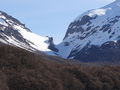
Paso el Peñón at the end of October 2013. A lot of Soft Snow
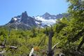
The dramatic views as you approach Cerro Castillo. 2015
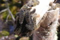
The northern sector of Cerro Castillo has been affected for some years by a plague of cuncunas, which are devoured year after year by trees. The plague advances and the cuncunas that are in the middle, die of hunger.


Revisa la lista completa de 621 rutas de trekking y las 345 rutas de montaña en Chile
|