Circuito Volcán Antuco (english)

|
Contenido
Right time
The right time for trekking is between October and April.
Access by car and the road status
From Los Angeles are 84 miles of paved path Q-45 to the village of Fan. Since there are 7 miles of volcanic rubble on good to the entrance of CONAF in Chacay.
If coming from the north, you can take the path O-97, which, at the height of Cabrera, born to the southeast toward Huepil (paved). From Huepil can continue along this same route to Fan, where much of the road is unpaved. If you want to avoid the rubble, turn into Huepil south to subsequently be taking the route Q-45.
Access by public transport and hitchhiking
Buses depart from Los Angeles bound for Fan (How Often? PRICE?). From there, you should hitch a ride to CONAF. The road is pretty flat, his condition is good and moderately high traffic, so the chances of success in the auto-stop is not bad.
Route description
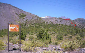
Since the goal of CONAF must go to the post Chacay (2 ½ miles, 1117m above sea level) either on foot or by vehicle. If it did so on foot, follow the Chilean Trail runs parallel to the road vehicle. From the post can see some blue and yellow houses, where one side begins "Velluda Sierra Trail, marked with a sign CONAF See Photo2. This is internal to the south by a grove of cypresses scattered. After a few hundred meters, it begins to climb the slope leading to the slag heaps of lava, not even visible. The trail is well marked throughout this stretch. During the first few meters of climbing the steep and loose soil are suitable for fall.
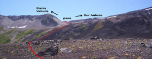
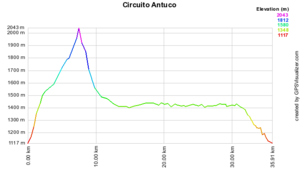
After overcoming the first slope (½ h), there is a sign of CONAF to signal "the Foxes" to the right path that should not be followed (in the letter IGM is named "The Pangues" to this trail, which leads less than 1 hour in a meadow, surrounded by cypress trees and coigües, and the estuary The Pangues). The path to follow, always well marked, continues to climb through the same vegetation by mild slope, up to the heap. Since then the landscape and topography changes abruptly away all signs of life and the land flattens. Addition, the trail becomes more difficult to follow. From here you have to go to the pass that separates the hill Antuco volcano Sierra Velluda, which is visible to the southeast View Photo3. Just at the beginning of the heap you must cross a stretch of newer lava, dark and harsh, quite uncomfortable to walk. Exercise caution on this stretch to keep the path (poorly marked with some very thin sticks and a pair of rocky promontories). It briefly goes south to reach the old lava, more apt to move. then tuck the road almost directly to the "step", provided by the northern bank of the estuary The Pangues. At the start of the heap 1700m (straight), there is a natural arch over the stream of lava, but this is off the beaten path, about 200m south. The trail is marked due to the transit of animals, but disappear with ease. Towards the end of the valley slope is increased to achieve step (2054m), marked with a monolith. They are running 6km from the start of the heap, which can be covered in 2h-3h. From there you can see the southern end of Lake Laja and international Pichachén step. The view is breathtaking, with glaciers on the north side of Sierra Velluda and the south side of Antuco nearby. The trail then drops abruptly to another valley, with some short stretches of carries. Once again reaches the bottom of the valley, we will find a stream that will be with us for a good stretch. After less than two hours of walking, after crossing several smaller streams that feed the main vehicular road is reached leading to Pichachén step. Slightly less than 1km before the road, stands a solitary monkey puzzle. 2.5 miles to the right, there is a shelter-office of Los Barros, where he began the fateful march in May 2005 that culminated in several conscripts killed in the storm. The route, however, continues to take the road to the left, to the north. What follows is a long walk at the foot of Antuco, bordering the lake Laja. They are about 17 miles of walking through a landscape devoid of vegetation, making it essential wear for sun protection. It is not unlikely hitch a ride on this stretch, but the walk takes about four hours to the ski resort. Then, are 4.3 miles down to Chacay provided by the vehicular road.Expected Time
At a normal pace, this trek should take about 9 to 11 hours left and came to Chacay without hitch in the vehicle section. Indeed, it is best done in two days.
Permits / Fees
- You must cancel the entry to CONAF, $ 700 per adult.
Recommendations
- You can ask more detail in the nursery of CONAF: 43-321086.
- The park is open from 8:30 to 20 hours between December and April and between 8:30 to 18:30 from May to November.
Ascent of Antuco and Sierra Velluda
- Antuco normal route from ski center
- Antuco Head south from Chavay
- Antuco Head south from Los Barros
- Sierra Velluda, Route from Los Barros
Waypoints in Google Earth
- Waypoints Antuco circuit. The waypoints were measured in Feb-06, but the layout is only indicative. Includes Antuco points for promotion to the north and south sides. To download the file right-click and then select "Save file as" (IE) or "Save link as" (Firefox, Chrome). By trying to open it directly, some browsers will show the raw code with the coordinates.


