This article is just a draft. You can help by expanding and improving its content
|
|
|
| Summary (editar)
|
| Activity
|
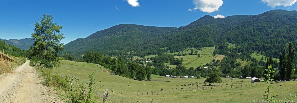
Trekking
|
| Location
|
Chile, Temuco
|
|
|
| Atractions
|
Vistas panorámicas
|
| Duration
|
días "Días" no está en la lista de valores posibles (3 horas o menos, 1/2 día, 3/4 día, 1 día, 1 día y medio, 2 días, 3 días, 4 días, 5 días, 3 - 5 días, 6 - 7 días, 8 - 10 días, 11 - 14 días, 15 - 20 días, 20 - 25 días, 26 - 35 días, 36 - 60 días, 61 - 89 días, más de 90 días) para esta propiedad.
|
|
|
| Trail
|
Siempre Claro
|
| Signage
|
Inexistente
|
| Infraestructure
|
Inexistente
|
|
|
|
|
| Topology
|
Cruce
|
| Gain/Loss (meters)
|
+1466, -1916
|
| Distance (k)
|
51
|
|
|
| Skills
|
No requiere
|
| Original creator
|
Jan Dudeck
|
| Download KMZ/GPX
|
Debes registrarte para descargar. Formulario es BREVISIMO
|
|
|
| Para ver estos botones debes registrarte. Toma 30 segundos: es un formulario minusculo, de solo 3 campos obligatorios.
|
|
| All GPT sections (click to show)
|
|
GPT Section Articles
|
Recent Alerts and Suggestions
Season Section Log
- 2019-Nov-26 / Shaun C / 2 days / Southbound / Regular Hiking Route
Straightforward. Took a short 2 days. Rained incessantly, but still very pleasant, especially the misty Laguna Hualalafquen. Water readily available throughout. Only a few patches of snow (above 1200m).
Summary Table
GPT15: Curarrehue
| GPT15: Curarrehue
|
Hiking
|
Packrafting
|
| Group
|
C: Zona Pehuenche
|
Total
|
51.1 km
|
15 h
|
51.0 km
|
15 h
|
| Region
|
Chile: Araucanía (IX)
|
Trails (TL)
|
9.3 km
|
18.3%
|
7.7 km
|
15.1%
|
| Start
|
Reigolil
|
Minor Roads (MR)
|
32.2 km
|
63.1%
|
32.2 km
|
63.2%
|
| Finish
|
Currarehue
|
Primary Roads (PR)
|
9.5 km
|
18.6%
|
9.5 km
|
18.6%
|
| Status
|
Published & Verified
|
Cross-Country (CC)
|
-
|
-
|
-
|
-
|
| Traversable
|
Nov - Apr (Maybe: Sep, Oct, May)
|
Bush-Bashing (BB)
|
-
|
-
|
-
|
-
|
| Packraft
|
Deployable
|
Ferry (FY)
|
-
|
-
|
-
|
-
|
| Connects to
|
GPT14, GPT16
|
Investigation (I)
|
-
|
-
|
-
|
-
|
| Options
|
82 km (2 Options & Variants)
|
Exploration (EXP)
|
-
|
-
|
-
|
-
|
|
|
Hiking
|
Packrafting
|
|
Total on Water
|
1.5 km
|
3.0%
|
| Attraction
|
2 (of 5)
|
2 (of 5)
|
River (RI)
|
-
|
-
|
| Difficulty
|
1 (of 5)
|
1 (of 5)
|
Lake (LK)
|
1.5 km
|
3.0%
|
| Direction
|
Both ↓↑
|
Both ↓↑
|
Fjord (FJ)
|
-
|
-
|
| Comment
|
-
|
| Character
|
Forest, Farmland, Pehuenche
|
| Challenges
|
-
|
Satellite Image Map
Elevation Profile
Elevation Profile of Regular Hiking Route
|frame|center|Elevation Profile of Regular Hiking Route (2019)]]
Elevation Profile of Regular Packrafting Route
[[File:|frame|center|Elevation Profile of Regular Hiking Route (2019)]]
Section Planning Status
Recommended Travel Period
Benefits of Hiking and Packrafting
Recommended Travel Direction
Section Length and Travel Duration
Suitable Section Combinations
Section Attractiveness
Section Difficulty
Resupply
Resupply Town
Shopping: Food
Shopping: Fuel
Shopping: Equipment
Services: Restaurants
Services: Laundry
Services: ATM and Money Exchange
Accommodation: Hostals and Hotels
Accommodation: Cabañas
Accommodation: Camping
Transport: Ground Transport
Transport: Ferries
Transport: Shipping Services
Resupply on the Trail
Location, Names, Available Items and Services
Access to Route and Return
Access to Start
Return from Finish
Escape Options
Permits, Entry Fees and Right-of-Way Issues
Regular Route
Regular Hiking Route
Regular Packrafting Route
Optional Routes
Investigations and Explorations
Links to other Resources
Alerts and Logs of Past Seasons


