GPT12 - Río Rahue
|
|
|
| |||||||||||||||||||||||||||||||||||||||||||||||||||||
Recent Alerts and Suggestions
* 06.12.19 / Sophie & Hendrik
The following is a chronological accumulation of all our observations made in the last 11 days. Note for navigation difficulties that we walked northbound.
- The most southern CC part direclty north of Liucura is now bordered by fences. You have to follow the path and then go left through a gate. The gate on the western fence is some 80m further south than you would expect. It was locked and we had to carefully (barbed wire) climb over it. It might be a lot easier to take the optional route in the east to get up the ridge.
-We were unable to find and follow the path at S38°24.881' W71°00.281' down to the valley. We endet up on a path a little further south. However, this path starts to lead further and further south, so that at some point we startet to ge back to the original path through the woods, which did cost several hours.
- Getting up the mountain at S38°24.450 W71°01.871' we startet ca 300m further north than indicated by the CC route due to fences and rivercrossing opportunities in the valley. (We thought CC means come up with your own route anyway.) At ca 1720m of altitude, still 300m north of the indicated route we found a good looking path leading up the mountain and followed it. At its end we assumed it would not be a bad idea to continue from here on in north west direction up the mountain. We now know it was a very bad idea. We ended up in a very uncomfortable and seriously dangerous climbing situation in which we really did not want to be. So our advice: stick to the route here!
- The Ford-125 (S38°20.908 W71°09.294') looks impassable right now. You can avoid it by using an improvised bridge about 120m further west.
- At roughly S38°17.091' W71°01.354' the path broke away into a very steep descent. It is passable, but also slippery and includes a certain risk of which you should be aware.
- The daily bus out of Ranquil does not stop at the busstation because it is too large to reverse there. You have to walk down the street ca. 2km to where a bridge crosses the river. The bus reverses here and does not go up further up the road. Right now it stops there at 6 in the morning.
Season Section Log
- 06.12.19 / Sophie & Hendrik / 10 days (45 walking hours) / Northbound / Regular Hiking Route from Liucura without the northern slope, so we went directly to Ranquil from S38°12.723' W71°05.208'.
In total we were 11days on the trail, of which we spend 1.5 in the tent due to bad weather. The route is free except for one fort, but there is a workaround. Also we had a couple of navigation problems, which cost us several hours. See recent alerts and suggestions.
We liked: The quickly chang landscape and its huge variety, beautiful cinematic views, funny animals, that water was always available, bathing in the rivers, beautifully blooming plants.
We did not like so much: The problems we encountered due to navigation mistakes, the hailstorm on the mountain ridge, beercans that people drop on the paths.
We bluntly hated: The amount of horse flies. In the northern part we were not able to make one step without having at least five buzzing arround our faces. This army of blood suckers was sent by a source of pure evil to annoy hikers.
Summary Table
Satellite Image Map
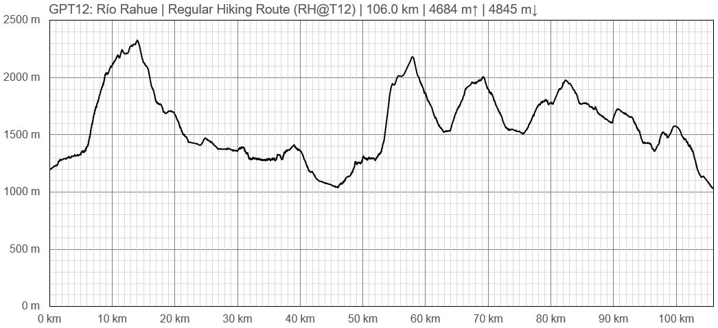
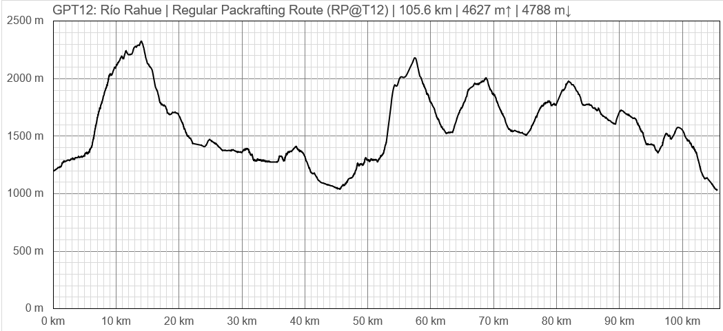
Elevation Profile
Elevation Profile of Regular Hiking Route
Elevation Profile of Regular Packrafting Route
Section Planning Status
Recommended Travel Period
Benefits of Hiking and Packrafting
Recommended Travel Direction
Section Length and Travel Duration
Suitable Section Combinations
Section Attractiveness
Section Difficulty
The isolation and the high passes make this a rather difficult but rewarding trail. Good orientational skill are required because hardly any signposts are placed and some parts of the trail are cross country. The electronic map Topo Chile Deluxe from Garmin shows the contours precisely but some lakes and smaller river are incorrect displayed. Only few trail sections are integrated. Some of the “Alleys” of this electronic map are far off the true position or inexistent. You should use the Greater Patagonian Trail data files for navigation.
Resupply
Ranquil - no shop but there are families who sold us sopaipillas
Resupply Town
Shopping: Food
Shopping: Fuel
Shopping: Equipment
Services: Restaurants
Services: Laundry
Services: ATM and Money Exchange
Accommodation: Hostals and Hotels
Accommodation: Cabañas
Accommodation: Camping
Transport: Ground Transport
Transport: Ferries
Transport: Shipping Services
Resupply on the Trail
Location, Names, Available Items and Services
Access to Route and Return
Bus from Temuco to Liucura every day (on weekdays at 12, sundays at 7.30am and 4pm_ status may 2019), 5 hours of travel. Bus from Ranquil to Lonquimay (on Mon, Wed and Fri at 6.45am from the village, at 6.20am on the road out of the trail approx 15 min of walk from the Carabiñeros).


