GPT32 - Cerro Castillo
|
|
|
| |||||||||||||||||||||||||||||||||||||||||||||||||||||
Recent Alerts and Suggestions
* 2019-Nov-29 / Lea Geibel, Kevin Moe
Snow line is at around 1200 Meters but all passes are safely traversable. The National Park Entrance Fee got raised to 29000 CLP per person for overnight hikes in season 19/20. The park generally seemed very poorly organized, we were told the passes are "closed" at first, whereas they were easy and safe to traverse. The ranger insisted that we could not hike the normal route northbound but have to sign out of the park at the Las Horquetas checkpoint. In high season, the ranger station in the park is manned, so maybe it is possible so sign out there and head northbound.
- 2019-Nov-12 / Eva Havlová
There is still lots of snow in the National Park. I arrived to Villa Cerro Castillo 3 days ago (Novembre 12, 2019) and planed to hike nortbound but rangers didn't let me go. I saw the pass they were talking about (avalanche risk) and I don't think any avalanche could occure, but the thuth is that there is lots of water runing down and the trail is like a stream. They said it might be possible to do it next week.
Season Section Log
- 2019-Nov-29/ Lea Geibel, Kevin Moe/ 3
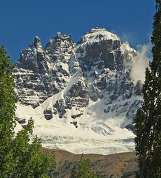
days / Northbound / Regular Hiking Route with OH-MR-V (Villa Cerro Castillo to Las Horquetas)/ The section follows the rather popular tourist Hiking route Las Horquetas for the first two days, meaning there will be less solitude but also rather well maintained trails. The national park and the region around Cerro Castillo was very impressive, we especially enjoyed to take all the side trails and visit the numerous beautiful glacier lagoons. The only unpleasant part of the hike was the organization of the national park. The exorbitant high entrance fees are in no relation to the other parks, which is due to a high ratio of private land in the area but makes the park rather unattractive for tourists. some rangers seemed poorly informed and couldn't give much information (e.g. insisted that passes were "closed" and only after asking numerous times agreed to check with his colleagues that told that they are "open"). They also said it is not possible to hike the regular route of the GPT, because we have to check out of the NP at the checkpoint Las Horquetas. There is an optional hiking route continuing North from there. Due to bad weather coming up we ended up not finishing the northern stretch of the trail and just followed the entire Las Horquetas Route at the Carretera Austral.
Summary Table
Satellite Image Map
Elevation Profile
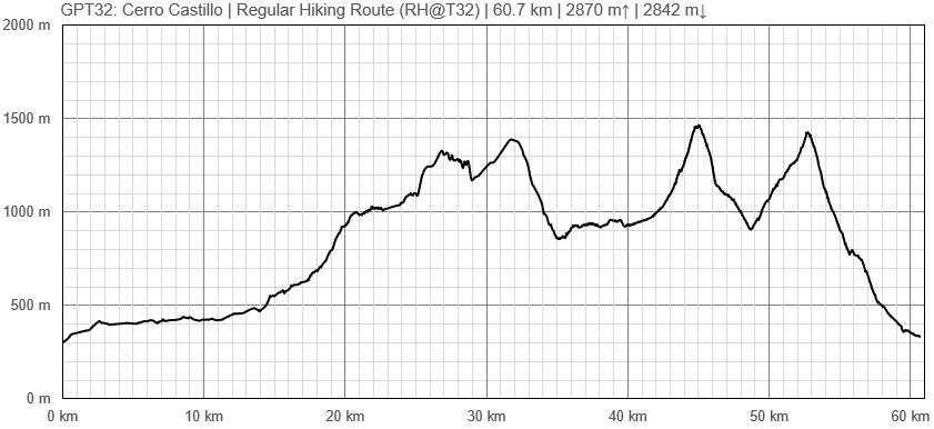
Elevation Profile of Regular Hiking Route
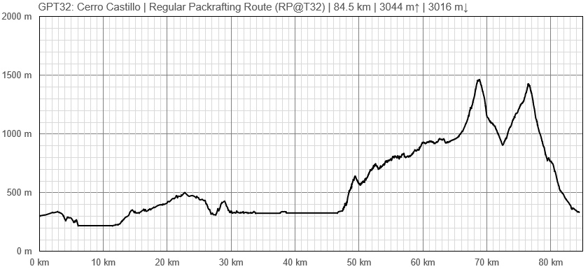
Elevation Profile of Regular Packrafting Route
Section Planning Status
Recommended Travel Period
Benefits of Hiking and Packrafting
Recommended Travel Direction
Section Length and Travel Duration
Suitable Section Combinations
Section Attractiveness
Section Difficulty
Resupply
Resupply Town
Town: Villa Cerro Castillo. Villa Cerro Castillo has several restaurants, small markets, and plenty of lodging options, including a popular backpacker camping destination on the east side of town.
Shopping: Food
Shopping: Fuel
Shopping: Equipment
Services: Restaurants
Services: Laundry
Services: ATM and Money Exchange
Accommodation: Hostals and Hotels
Accommodation: Cabañas
Accommodation: Camping
Transport: Ground Transport
Transport: Ferries
Transport: Shipping Services
Resupply on the Trail
Location, Names, Available Items and Services
Access to Route and Return
Access to Start
Return from Finish
Escape Options
Permits, Entry Fees and Right-of-Way Issues
Regular Route
Regular Hiking Route
Regular Packrafting Route
- Route description by Kara Davis after Season 2017/18:
A sandy beach with a visible structure in the grass is the take-out for Lago Elizalde. After exiting, make your way through the farmland until encountering a gravel road that leads past the house at the top of the hill up to Ruta X-686.
Ruta X-686 is a lightly trafficked but well-formed gravel road that is fenced on either side. After crossing the Río Paloma, Ruta X-686 makes a sharp left and begins to climb. 4 km after the sharp left turn, cross a bridge to the left and climb to a wooden gate. If you descend the steep slope to the left of the gate, there is camping under some trees.
The wooden gate marks the beginning of a very long driveway to a house located near the lake. The route takes you along this driveway until a river crossing. After crossing the river, walk northeast along its shore towards the Río Paloma. After reaching the end of the fenceline near the Río Paloma, turn east and walk along the fenceline until reaching Lago Desierto. At the river outlet, there is a nice beach to put in to Lago Desierto.
There is no camping along the shores of Lago Desierto. The take-out is a rocky beach at the base of a bluff. Walk up the bluff and cross country through the farmland to Lago Azul. At the east end of the farm, descend down a road to a rocky beach at the Lago Azul shoreline with a metal structure.
There are a couple of potential camping options along the shoreline of Lago Azul. There are also several residences on the north shore. The take-out is a long rocky beach set before a well manicured forest. On the east end of the land near Lago La Paloma is an expensive looking house surrounded by several other buildings.
There is a 4WD track to the west of the smaller red house located south of the big residence. Ascend the steep climb on a well-formed road that is criss-crossed with several smaller tracks labeled in english with wooden signs. Due to the steep slopes on either side of the cut out road, there is no camping here.
Eventually, the route turns off of the road onto an overgrown 4WD track. Camping off the track is still difficult because of prickly vegetation and steep terrain. This track ends 2.5 km from where the Regular Packrafting Route joins the Regular Hiking Route. From here, the route involves some bushwhacking and following a small trail as it winds in and out of existence. Just before joining with the Regular Hiking Route, the route widens into an old 4WD track that passes some destroyed structures.
The routes join up at a large rock cairn and continues to follow a 4WD track until reaching a large wooden sign with a map of the Reserva Nacional Cerro Castillo. Here there is also a campsite and ranger station. There is a 5.000 CLP fee to enter the reserve.
The route from here is a popular track for backpackers with designated campsites. The trail is well-formed and winds through the forest. When the trail becomes less obvious, the way is shown with yellow markers. In this area there is a designated campsite with a latrine.
At treeline, follow the cairns and rocks painted with white and red stripes through the scree up and over the first pass (approximate elevation 1.450 m). After the steep descent, reenter the trees. There is a campsite, Camping El Bosque, soon after reaching treeline (approximately elevation 940 m) with water and a latrine.
The trail begins to wind up through the forest toward Laguna Castillo. The sights from Laguna Castillo, which is at the base of the pass, are stunning. There are two tracks that climb up to the pass. Make sure to take the path that climbs to the south instead of continuing southeast over the obvious saddle.
The track down to Ruta X-720 is well formed, marked, and popular, but occasionally braided. Follow it until reaching the wooden stile with a rangers hut. From there join Ruta X-720, a dirt road which leads to Highway 7 and Villa Cerro Castillo.


