GPT19 - Volcán Puyehue
|
|
|
| |||||||||||||||||||||||||||||||||||||||||||||||||||||
Recent Alerts and Suggestions
Season Section Log
- 2021-Dec-03 / Alex Abramov / GPT19: Volcán Puyehue. Northbound.
The "Plateau" still has a LOT of snow.
- Feb 2020 / Matthieu / RR + ascent of the summit + OH to the Hot Springs, Northbound
Great section, amazing views, no technical difficulties with the trails and cross country..
- Fees : In this sense you have to pay the entry of the private property in Lican, at the camping/restaurant of the base of the volcano (10 000 CLP). The owner is called Santiago and is really nice, he gives you all the informations necessary for places to camp and water supply. I could take a photo of the touristic map too, which normally you have to pay for. Going southbound I don´t think that you have to pay something to enter the parc.
- Water supply : NO WATER at the first refuge down the volcano, you got to go a little bit further up and west. All the west flank of the volcano is full of little stream coming from the snow. On this part no difficulties. "Water 12?" wasnt working when I was though, but there was a last stream after before going west to the desert ( at the div 128).You have a good half day of walking without water, so take some supply with you. The water comes back just before the div 126, on a place which looks like a dry lake, with little streams coming down some frozen snow. There is another part without water, that begins a little after Div 126 until the refuge of Neri and Hector. I personnaly thought easy to find water in the forest and got really thirsty because of that. There was nobody in the refuge, so I could find water a few meters after the north gate of the house, following a little trail that went on the right side, directly in the forest and to the river. (A little bit of bush bashing at the end, next to the river). Further on the road down there was some other rivers and there and good camping sites. You join the real road at bridge 63 and no problems of water after.
- Optionnal roads : For the ascent of the volcano, I personnaly , on advice of Santiago, let my tent along the river "Water 145", souther from the waypoint. There are some flat places nice for the tent. From here you can go straight to the top, no technical difficulties.
For the Hot springs (nice experience, but the valley is full of tabaño at this season, so prefer arriving at the sunset to enjoy the water after !) : To go to the valley, I took a path that was on the touristic map but not on the GPT tracks. AFter the dry lake just before div 126 I followed the RR tracks up the hill, going east, and after I quitted the trqcks to go down directly to a little canyon, seeming to be a dry river. Really interessant path, and really easy, all flat in the canyon.It goes directly north and join the OH-TL-1901#001, making a triangle with the GPS tracks. There is a couple of hours walking after, in a nice green valley (plenty of water) until the hot springs. To enjoy the hot springs, I would recommend not to go (as I did) to the waypoint that will drive you in the closed canyon. The rocks in water are full of foam, and the feeling is really not good. I found a good place to camp and bath going back the next day, with traces of camping. About 300m before the waypoint hot springs, Just after the OH track makes a sort of right angle, the river take a shape of sharp angle and there is sand in the found of the river to sit and enjoy without slipping (GPS point of this site :S40°28.036' / W072°12.519'). To go back I followed the OH tracks until the RR, passing by the Geysers.
- Rivercrossing : one, the Rio Hueinahue. The GPS tracks are a good place to cross, going there the rocks before a rapid The river is very large thow, and the rocks slippery. When I passed I had maximum water a little bit above the knees. It is easier to see the good path in the river arriving southbound, because the road is up the river,but it is not so clear going northbound, If you are not confident with rivers, there are bridges up the road, not very far. Better not take useless risks.
- Ressupply locations : Nothing in Rupumeica. Little shops in Maqueo and Maihue. A lot of camping sites, free and payable, along the Lago Maihue.
- 2020-Feb-19 / Martina & Ivo / Regular route southbound (start: km 37, end: Anticura)
2.5 days. Actually we wanted to hike from Riñinahue, so we took a random Bus in Osorno (09:20) to Río Bueno, where there was a connecting Bus to Lago Ranco, where there was another connecting Bus to Riñinahue, and this one continued - to our astonishment - to the bridge over Río Nilahue, where the optional route meets the regular route. We found water in the forest at both waypoints "water?", but we went after a period of heavy rain. The "water?" before the pass is still flowing and there is a lot of snow left to keep it flowing. The section was unexpectedly physically demanding but extremely beautiful! In Anticura we found accommodation, but we didn't look for resupply, which is probably not so easy...
10-02-2020 / Ty/ RR SOBO/ 3 Days I got lucky and got a ride all the way up to Los Venados. I went around Hectors house and camped up before tree line. There’s a bit of water still up there, just a few strong trickles though. I thought they would stay running for a while. Then for day 2 I went to the refuge, with a slight detour to the rim of the volcano. Definitely recommend. The “water?“ at RR-CC-A@19-68.0+3.7 seemed to have plenty in it at the time as well. At the rim a cloud came in and made navigation pretty tricky, but easily managed. Nice refuge with campsites outside. Spring still running. Tables and everything! Overall, an amazing section. From the end I hitched up to Antillanca optional Start for the next section.
16-01-2020 / Arnaud Debilly / Southbound 4 full days We ressuplied in Curiñe, with a minimatket there. To avoid the 15 first kilometers we took the bus from puerto Maihue to Rupumeica Bajo. We slept in the cabañas of Carmen Panguilef (+56 984 54 83 03) in rupumeica bajo who is very welcoming and a proud mapuche. Then the road ends and starts the path to cross the pass to rupumeica alto. Then you follow the minor road until los Venados. The road is blocked by barriers that we crossed easily. At los Venados the path is clearly private and is along the house of Hector. We met him and his wife and they easily let us go through. We overcarried water because we feared the lack of drinkable water. Until almost the treeline, you can hear little rivers not too far from the path. We also drunk melted snow at the top so we had enough. Later in the season, it might be drier (I assume, those little rivers come from the snow melting). The last real rio is just before los venados. After the forest, the volcanic terrain is very easy to walk in and the landscapes are wonderful. We saw many smokes from the volcanic activity but seemed not dangerous. Check the status of the volcano before to go (www.sernageomin.cl). Following the track, it is easy to go between the lava field. Campsites are absolutely great, with an amazing view on the vulcano. We felt an earthquake (5,2) that has been localized near san martin de los andes in Argentinia but it made nothing dangerous with the volcano, luckily. We have had a perfect blue sky without wind during the 2 days on top, it could not have been better. The refugio El Caulle, at the start of the downhill can be a good protection for a bad weather. We found a little spring, to resupply water in the dry rio just under the refugio. On the volcanic terrain, a bad weather changes everything and it must be really difficult and unpleasant to finish this section with rain, snow or wind and without the view. It was for us the most wonderful section we have had until today.
---
January 2020
- The Puyehue Traverse - GPT19*
Okay. This is my first conditions report. I walked the Puyehue Traverse with my parents over the last week. It is basically the last part of GPT19, starting on the rd to Héctor y Neri's (Los Venados)(phone beforehand to secure permission : +569 81868927). Let me know if I should structure it differently in the future.
- Getting to the Los Venados from Osorno *
We caught the bus first to Rio Blanco, another to Largo Ranco. We then lucked out that the Riñinahue bus happened to be passing through! I think this is only once a day and goes all the way to the turn off to Cruce Pichico (3.8km from the turnoff to Los Venados). Again we were lucky and managed to hitch a ride (with two anthropologists!). A car past telling us they (Héctor and Neri) weren't home so we took the bypass - not sure if this is private or not? We made camp by some water for the night.
- Up into the park*
There is more water available if you're willing to walk off the main track. Numerous times I heard water off to the sides. The first water close to the track was after you pass the national park sign where marked in the section pts. Then above the treeline there are better sources available from the snow melt (better and more numerous later in the day). From the geothermal site we side tripped into the valley for a day and came back along the ridge to the SW. The valley has a lot of streams and some great camp spots. You could even do a shortish 2hr detour to camp in the treeline here. We took some slight variations to the optional hiking route.
- Passing the recent lava flow *
Rejoining the RR at a lake we followed the wall around camping a night part way along. (met four French ppl hiking the GPT here). There is snow, but no really good water sources until you get to the points marked at the base of Volcán Puyehue (first one here -40.59224, -72.13547).
- Climbing the volcano *
In short. We didn't. We woke to rain and retreated to the refugio. We spent the day cleaning it. So much rubbish! Carried a load down but there is a lot more if anyone feels like it. It snowed overnight. There was snow down to the refugio at 1400m but only persisted to maybe 1600m. We couldn't see the top of the volcano and in the afternoon, with food running low, decided to bail. The hut has a dunny.
- Getting back into Osorno *
After waiting three hours for a bus we ended up hitching a ride in una camión. He told us we would have been waiting a long time. Maybe one bus a day. Not really sure. But getting there early is a good idea. Coming down you could camp where the rd starts if you want to save money on lodging. We then caught a bus back into Osorno.
24-Jan-2020 Tom & Maddie Regular route SOBO starting from 37km, 1 day and nero. Incredible section! We had no particular issues. It is possible to collect some water along the traverse after Hector and Neri’s property, however no reliable water sources are available until after the pass. There are some small streams flowing from the snow at the top so finding water is not impossible. We carried 3L per person and it was the right amount of water, including a side trip to the summit not on a track listed in the files. I would recommend doing the whole traverse in one day due to the limited water and the exposed nature of the area. Good weather is preferable, not just for the amazing views but also for safety reasons. The refuge at the other end of the pass is quite nice and a good place to spend the night.
Summary Table
| GPT19: Volcán Puyehue | Hiking | Packrafting | |||||
| Group | D: Lagos Chilenos | Total | 83.0 km | 28 h | 70.0 km | 23 h | |
| Region | Chile: Los Ríos (XIV) & Los Lagos (X) | Trails (TL) | 5.4 km | 6.5% | 5.4 km | 7.8% | |
| Start | Puerto Maihue | Minor Roads (MR) | 55.8 km | 67.2% | 34.2 km | 48.8% | |
| Finish | Anticura (CONAF) | Primary Roads (PR) | 2.2 km | 2.6% | 2.2 km | 3.1% | |
| Status | Published & Verified | Cross-Country (CC) | 19.7 km | 23.7% | 18.6 km | 26.6% | |
| Traversable | Dec - Mar (Maybe: Nov, Apr) | Bush-Bashing (BB) | - | - | - | - | |
| Packraft | Useful | Ferry (FY) | - | - | - | - | |
| Connects to | GPT18, GPT20 | Investigation (I) | - | - | - | - | |
| Options | 216 km (6 Options & Variants) | Exploration (EXP) | - | - | - | - | |
| Hiking | Packrafting | Total on Water | 9.6 km | 13.8% | |||
| Attraction | 5 (of 5) | 5 (of 5) | River (RI) | - | - | ||
| Difficulty | 5 (of 5) | 5 (of 5) | Lake (LK) | 9.6 km | 13.8% | ||
| Direction | Both ↓↑ | Both ↓↑ | Fjord (FJ) | - | - | ||
| Comment | - | ||||||
| Character | Valdivian Rain Forest, Volcanic Terrain, Summit Ascents, Hot Springs, Settlers, Lake Packrafting | ||||||
| Challenges | Exposure to Elements, Demanding Navigation, Lack of Drinking Water | ||||||
Satellite Image Map
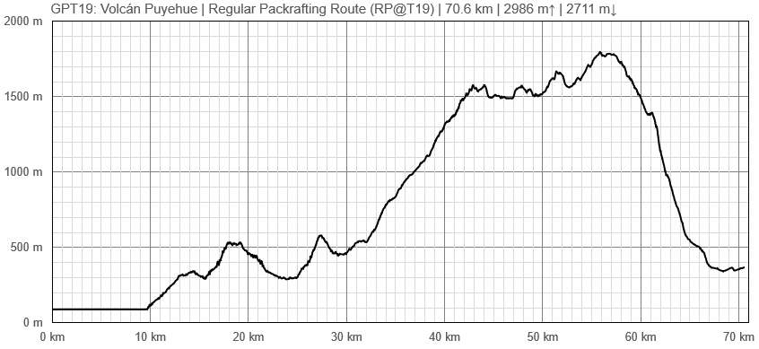
Elevation Profile
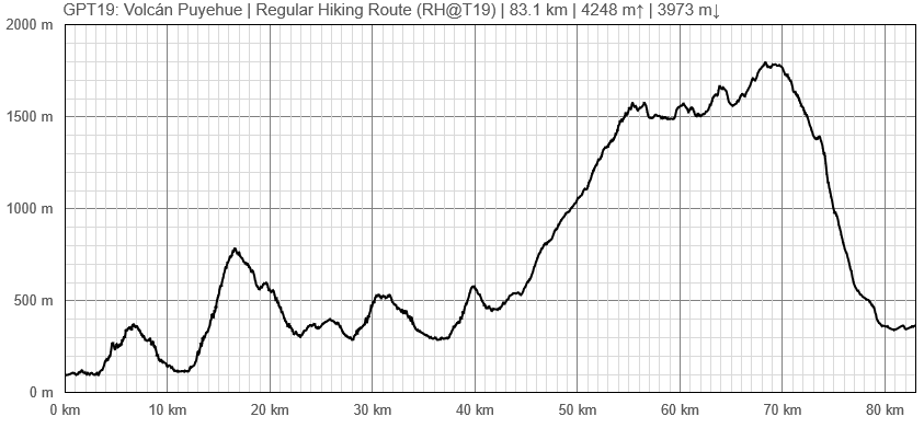
Elevation Profile of Regular Hiking Route
Elevation Profile of Regular Packrafting Route
Section Planning Status
Recommended Travel Period
Benefits of Hiking and Packrafting
Recommended Travel Direction
Section Length and Travel Duration
Suitable Section Combinations
Section Attractiveness
Section Difficulty
Resupply
Resupply Town
Shopping: Food
Shopping: Fuel
Shopping: Equipment
Services: Restaurants
Services: Laundry
Services: ATM and Money Exchange
Accommodation: Hostals and Hotels
Accommodation: Cabañas
Accommodation: Camping
Transport: Ground Transport
Transport: Ferries
Transport: Shipping Services
Resupply on the Trail
Location, Names, Available Items and Services
Access to Route and Return
Access to Start
Valdivia to Maihue:
A bus goes directly from Valdivia to Maihue where the regular route starts, and even further down the gravel road all the way to Rio Hueinahue. It passes by Futrono
Osorno to Riñinahue:
There are a lot of Busses going from Osorno to Río Bueno, where you have to change Bus to Lago Ranco, where you have to change again to Riñinahue. If you take the 09:20 Bus in Osorno you get the once-a-day-connection that goes further than Riñinahue, until the bridge over Río Nilahue, where the optional route meets the regular route.
Return from Finish
Anticura to Osorno: once a day at 07:30 at the Ruta International in front of CONAF.
Dec 2021: The bus driver in Osorno says that the bus currently doesn't travel further than Puyehue due to the pandemic, so maybe it won't arrive in Anticura? It's about 10 km so could be walked though
Escape Options
Permits, Entry Fees and Right-of-Way Issues
The regular route passes through the property of Héctor y Neri's (Los Venados). They prefer you phone beforehand to secure permission : +569 81868927.
Regular Route
Regular Hiking Route
- Route description by Kara Davis after Season 2017/18:
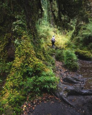
GPT19 begins at the northeastern end of Lago Maihue. The regular hiking route follows T-559, a nice road with beautiful overlooking views of the lake, for many kilometers. Less than a kilometer after the GPS track turns east to contour the north bank of Río Hueinahue, the track turns off of T-559. There is no trail at the turn off, continue cross country until reaching the road on the other side. Be careful crossing this river! At high water, it may be a good idea to walk the few extra kilometers to the T-559 bridge crossing. The river is wide and the river bed was slippery.
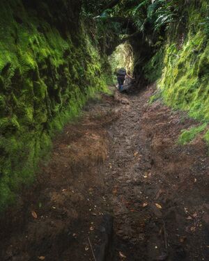
Soon after rejoining T-559 on the south side of Río Hueinahue, turn right onto T-537 and begin to steeply climb. After about 2 kilometers, the road reduces to a very rutted trail with occasional spurs and limited camping. The route joins a gravel road T-567, for about 27 km until the turnoff onto Camino a Predio Contrafuerte, a smaller gravel road. After about 16 km, the road ends at a residence that the GPS route apparently goes right through. This house belongs to Nari and Hector, a wonderful older couple who are very used to hikers coming through their property on their way to Volcán Puyehue. Don’t be too alarmed with the barking dogs, go in and introduce yourself!
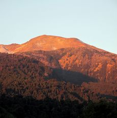
From Nari’s house, there is NO WATER until halfway down the descent of Volcán Puyehue!! It may be possible to grab a drink from some melting snow but don’t count on it during low snow years. Climb a wide rut up the hill behind Nari’s house. The rut reduces to single track and continues to climb through an open forest with plenty of places to camp. After reaching treeline, the trail disappears. You may see the occasional cairn or footprint, but for the most part this is cross-country travel until treeline on the south side of the volcano. The landscape through this section is alien and breathtakingly beautiful.
Just before the very steep descent at approximate elevation 1.400 m, there is a small hut which is popular with hikers climbing the volcano. Descend on a nice trail through the forest with limited camping options. As you approach the road, 215-CH, the route passes by several small cabins. Just west of where the route intersects 215-CH, is a bus stop. The nearest large town is Osorno (see town description in GPT20).


