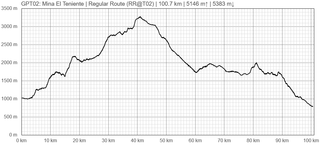
GPT02 - Mina El Teniente
|
|
|
| |||||||||||||||||||||||||||||||||||||||||||||||||||||
Recent Alerts and Suggestions
- 2021-Nov-12 / Marc Anthony
Big locked gate at -33 40.961’ -070 20.773’ after leaving el melocotón heading south. Didn’t find anyone around to ask, but luckily it can easily be jumped if you walk around on the left side. Carry a lot of water! Quite a few kilometers between the water sources. Theres a waypoint in the track files at -33 43.298’ -070 20.705’ that is marked “Water ? 02”, there is no water here! But I found an unmarked water source a few kilometers further at -33 44.474’ -070 21.204’ When walking down from mountain pass towards the mine, the last water source I found was at -34 04.070’ -070 29.602’ marked in track files with “Sobo: Last water 25 km ???”. In was only running a little bit, might dry out soon? At the walking into the plantation area close to the mine on the regular route you will encounter a tall locked gate at -34 04.123’ -070 30.702’. I was able to jump over, but keep in mind that there are a lot of the workers at the plantation driving on the road next to it during the day. If you when you continue through the plantation you will encounter a barbed wire fence that runs all the way across the area blocking the path up onto the mountains. Very difficult to jump over! I noticed another gate when walking straight ahead after jumping the first gate. Would advice that you jump over this gate to exit the plantation, instead of following the track files. This way you avoid the barbed wire.
- 2019-Nov-28 / Family Size
The campground Estero Coyanco (S 33° 40.950', W 070° 20.779') seams to be only open on weekends? One can walk around the closed gate and a person in the campground allowed me to sleep there on a weekday. There would be a small shop, food places and toilets. I stayed up the valley close to S 33° 40.950', W 070° 20.779'.
There was a dead goat further up in the water.
- 2018-Dec-20 / Martin Lizondo / Regular Route Southbound
A lot of water capacity is required. Last water source at Estero Bodegua (S34° 00.894' W70° 25.507'). Avoid the route near puesto at S34° 04.633' W70° 30.757' because the pass is forbidden. Instead, keep following the track high off trail.
Season Section Log
- 2021 Nov-20, SOBO, RR, Kris&Stiina
Locked gate (-33.682407, -70.346283) on the route in the beginning of secotion is for the entrance of Reserva Coyanco. There was a lady that opened the gate and said that one day pass through the reserve costs 5000 pesos, but that we can pay it somewhere later. But as the RR doesn’t continue up the valley but across the bridge and up the ridge from the other side then we didn’t meet anyone who would collect the fees. It could be that it’s a weekend thing as there were quite a few people in the area mostly going to see the Calabozo del Diablo.
No water at the first marked location with question mark (-33.72155, -70.345093), but as Marc Anthony already mentioned there is a small stream of water about 3km further (-33.741233, -70.3534). After that once you reach the first ford there was a lot of water in almost every gully, especially as you reach higher elevations. Snow patches are still melting and providing water. The last water is where it’s marked.
We didn’t jump the gate to walk in the plantation, but walked around the fence, handrailed it. There is a faint path for first few hundred meters and then it’s and easy cross country, just aim for the shoulder on the mountain. The last part was actually really beautiful and I wouldn’t want to skip it, we had a cloud inversion in the morning and about 8 condors circling us, spectacular.
On average we carried 1,7L of water each and besides the first part until the first water and the last part from the last water there really was plenty of water on trail and we could have easily carried only a litre each. For the last part we carried 10L for both of us and it was enough for dry-camping on the ridge and washing dishes and we ended up pouring out about a litre in the morning because we didn’t need that much water.
Once we descended to the road we had an easy hitch to Machali where we resupplied and hitched back to Coya, again an easy hitch. No gas canisters with thread in Machali but we found some in Coya.
It took us 4 and a half days to hike this section, our last camp was about 9,5km from the road.
We ate some great food and recharged all of our batteries in a Peruvian restaurant “Sumaq Ñusta” in Coya before heading back out on trail.
For more stories of the trail, pictures and videos you can find us on Instagram: @smallfootprint_bigadventures
- 2021-Nov 12 / Marc Anthony / RR SoBo
Took me 4 days to hike this section, but I took the emergency exit number 2 because I ran out of water, so didn’t do the last few kilometers.
All the river fords were easy. Quite a long distance between water sources in the beginning. Like in GPT 1 i found the beginning of this section to be quite difficult because of the heat even though it is still springtime. But I only have experience hiking in Scandinavia, so I probably don’t have the best heat tolerance :) As soon as I climbed up to the cooler temperature of the higher altitudes it was a wonderful hike.
Had a lot some trouble with locked gates and barbed wire fence when entering the mine/plantation area. And unfortunately ripped open my plastic water bottle when throwing my backpack over the barbed wire, so lost some precious water.
After a several hours of hiking in the mountains next to the mine I ended up taking emergency exit number 2 because I was running low on water. Must admit that hiking in this exposed terrain during the afternoon heat was also quite exhausting. The guards that picked me up after a while when waiting by the road where extremely jolly and nice. We had a good talk and some good laughs about the whole situation. They gave me water and put me on a bus to Coya by mine entrance. Bus driver even drove me around town so that I could find a open hostel. Certainly didn’t expect all this kindness when trespassing private property! Ended up in a place called Hostel Vista al Cerro in Coya
- 2020-Nov 7 / Fran & Rodri
We walked GPT02 in five days, at first, we wanted to start from Reserva Río Clarillo but it was impossible. The guards of Conaf didn't even try to listen to us, they just said "you can't pass", so we try the alternative across the river and after 5km, they caught us, it's a natural private reserve and closed for public ( more strict than conaf) so they kick us out. Finally we start in the regular route in "El Melocotón".
The entrances it's a private turism property, once inside, you have 2 alternatives, we took the regular because of the water but we had to pay 5.000 pesos each.
Then we walk in and the problems dissapear. in the beggining the water spots are between 7km aprox so be carefull with that.
In the second day we have a lot of river crossing but it was easy. A lot of sun.
At the end of the route we took the emergency exit 1 in the "MinaTeniente" of course its a super private zone, but they were very friendly, make us a lot of questions, our personal details and they took us to the end of the privete zone. Then we walk 5km and arrive to Coya.
In town there is a very good place to eat called "bar catan" (delicious and cheap), and pass the night in "Hostal el ensueño" (15.000 each).
- 2019-Nov-24 / Matus & Anna
We walked GPT02 five days. Including 2 nero days. Again a really hot section, but there is enough water till Estero Codegua. Marked source before mine (water last 25km) is still flowing. Not much, but flowing. After that you won't find any. Trail is in good condition, in few undefines spots just follow gps. We took last optional trail to the left to meet road to Coya, trail was bit overgrown but doable, then we took a regular trail to Coya which is gravel. Shortly after first emergency exit in mine, where is trail cutting a mine property, they are building a high fence that won't be easy to jump. In Coya we are staying in Tu Casita for 20k including dinner. So far it's nice. Ressuplying is good here, we found everything that we needed.
- 2019-Nov-16 / Martina & Ivo / Regular route southbound
It took us 4 days to walk this section. Trails are in good condition. There is practically no snow left and water levels are low. We took the third Emergency Exit in the mine, so we don't know about the last 10 km. The mine's Security Officer wasn't very pleased to drive us out of the mine. In Coya we found accommodation and resupply tiendas. You can also take the bus to Rancagua which runs every full hour.
- 2019-Nov- 14 / Ty & America / SOBO.
•We camped on Reserva Coyanco for 5000 pesos and sweet spots right next to the river. We took a taxi straight there from the city center of Santiago for 25,000. I just saw on the television that the metro is back up to Puente Alto as well.....so that’s cool. •We also took the first emergency exit when arriving at Mina Teniente. Everybody was SUPER friendly. They even gave us a free ride to Machali for Resupply (Isabel supermarket). •After water at the bridge over Estero Codegua, water is pretty much non existent. Nobody was at the puesto, and the next water source was still and dense with tad poles (definitely not ideal)....and probably won’t last for much longer. •There was some just recently passable areas near the top of the pass, but pretty easy to get by! Prefect timing 👌
Summary Table
| GPT02: Mina El Teniente | Hiking | Packrafting | |||||
| Group | A: Precordillera | Total | 105.8 km | ' | - | ' | |
| Region | Chile: Metropolitano (V) & O'Higgins (VI) | Trails (TL) | 49.8 km | 47.0% | - | - | |
| Start | El Melocotón | Minor Roads (MR) | 44.4 km | 42.0% | - | - | |
| Finish | Coya | Primary Roads (PR) | 4.6 km | 4.4% | - | - | |
| Status | Published & Verified | Cross-Country (CC) | 5.9 km | 5.6% | - | - | |
| Traversable | Dec - Mar (Maybe: Nov, Apr) | Bush-Bashing (BB) | 1.1 km | 1.0% | - | - | |
| Packraft | Only Burden | Ferry (FY) | - | - | - | - | |
| Connects to | GPT01, GPT03 | Investigation (I) | (0.7 km) | (0.6%) | - | - | |
| Options | 41 km (Variants Only) | Exploration (EXP) | - | - | - | - | |
| Hiking | Packrafting | Total on Water | - | - | |||
| Attraction | 2 (of 5) | - | River (RI) | - | - | ||
| Difficulty | 3 (of 5) | - | Lake (LK) | - | - | ||
| Direction | Both ↓↑ | - | Fjord (FJ) | - | - | ||
| Comment | - | ||||||
| Character | Semi-Desert, Alpine Terrain, Mountain Pastures, Mining, Arrieros | ||||||
| Challenges | Exposure to Elements, Clambering, Demanding Navigation, Lack of Drinking Water, Resupply Distance, Right-of-Way Disputes | ||||||


