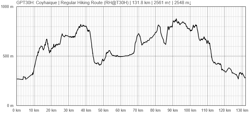
GPT30H (Coyhaique)
Add a new log entry always on top in the appropriate season sub-chapter and use format:
* Start Date to Finish Date (use Format YYYY-MMM-DD) / Duration in Days / Hiking or Packrafting / Travel Direction (SOBO for Southbound or NOBO Northbound) / Chosen Route and/or Option Name (RR for Regular Route) / Names or Alias
Summary with remarks to route that are considered useful for other hikers and packrafters. Include alerts, suggestions and personal perception of attractiveness and difficulties.
Add a sub-chapter by placing two "=" before and after the new sub-chapter heading ('==Sub-Chapter Heading==').
Contenido
Section Log, Alerts and Suggestions
Season 2025/26
Season 2024/25
Season 2023/24
Season 2022/23
- 27 Nov 2022 Frank
Rio Nireguao near El Gato was not fordable in late November - chest deep & running fast. It was easily fordable & only knee deep in late January. Rio Nireguao is the only serious ford on GPT30. All other rivers had bridges or were easily fordable. It is highly advisable to attempt the ford SOBO only. It's a 10 minute walk from the road. If you are unable to cross it NOBO you will have to backtrack for 1 or 2 days.
Reserva National Coyhaique is open Tuesday-Sunday 9:00-16:00 but: You are required to register your visit on www.aspticket.cl Entry costs 6200 pesos for foreigners. The only trail currently open is a loop walk to Laguna Verde, not on the GPT. I asked if I could walk NOBO to exit the park at Rio Baguales. "No, closed" To avoid complications I walked around the park on the road. I got the bus to Rio Baguales & walked to Coyhaique, 13KM downhill. Any bus to Villa Ortega can drop you there. There is a carabinero post at Rio Baguales, I'm not sure if they would let you walk through it to enter the Reserva SOBO. Road is busy & parts are very dusty, not a nice walk, you could bus around it to start at Rio Baguales.
Season 2021/22
Season 2020/21
Season 2019/20
Season 2018/19
Season 2017/18
Season 2016/17
Resupply and Accommodation
Resupply and Accommodation in nearby Towns
Resupply and Accommodation along the Route
Transport to and from Route
Permits, Entry Fees and Right-of-Way Issues
Links to other Resources
Retired Section Article GPT30H - Coyhaique
Images
[[Archivo: | ]]
| GPT30H: Coyhaique | Hiking | Packrafting | |||||
| Group | G: Aysen Norte | Total | 129.1 km | 41 h | - | - | |
| Region | Chile: Aysén (XI) | Trails (TL) | 21.5 km | 16.6% | - | - | |
| Start | Carretera Austral (Camino Picaflor) | Minor Roads (MR) | 38.9 km | 30.1% | - | - | |
| Finish | Coyhaique | Primary Roads (PR) | 49.3 km | 38.2% | - | - | |
| Status | Published & Verified | Cross-Country (CC) | 17.5 km | 13.6% | - | - | |
| Traversable | Jan - Apr (Maybe: Nov, Dec, May) | Bush-Bashing (BB) | 2.0 km | 1.5% | - | - | |
| Packraft | Only Burden | Ferry (FY) | - | - | - | - | |
| Connects to | GPT29H, GPT31H | Investigation (I) | (3.6 km) | (2.8%) | - | - | |
| Options | 109 km (1 Options & Variants) | Exploration (EXP) | - | - | - | - | |
| Hiking | Packrafting | Total on Water | - | - | |||
| Attraction | 2 (of 5) | - | River (RI) | - | - | ||
| Difficulty | 3 (of 5) | - | Lake (LK) | - | - | ||
| Direction | Both ↓↑ | - | Fjord (FJ) | - | - | ||
| Comment | - | ||||||
| Character | Forest, Farmland, Settlers, Road Walking | ||||||
| Challenges | Demanding River Fords, Resupply Distance | ||||||

