GPT35 - RN Lago Jeinimeni
| All GPT sections (click to show) |
|---|
|
GPT Section Articles
|
Recent Alerts and Suggestions
Season Section Log
- 2020-January / Matthieu / Northbound : 7.5 days "tranquilito"
Incredible trekk, lots of different type of views and soil, my favorite since El Chalten. Money required for passing by the reserves !! I hitchhiked 10 km on the road to Casa Piedra, and 12 km between Jeinemini qnd the beginning of the trail that goes north in the mountain to join Chile Chico.
1st part : Reserve Tamango : 6000 CLP the entry I took the old "Huemul trail" in the Tamango reserve, taking the left route at the "Camp 284" It is an old trail for 4x4, so very easy, and closed to vehicles now.
2nd part : The road to Casa Piedra : the rangers I crossed were all agreed that it was not permitted to camp aside of the road (so the information is different that in Nov). One officiql camping at the end of Tamango reserve (WestWine) and one at Casa Piedra 26 km after. 8000 CLP each. At Westwind : no accomodations, only baño. At Casa Piedra . real big house, hot shower, place to cook.
3rd part : Reserve Jenemeni : Entry 8000 CLP. For the camping, the ranger told me that it was permitted to camp wherever I wanted, so the information differs too from november. And at the exit, I told the ranger about my "savage" camping in the conversation, and he didnt tic at all, so no stress. The rangers are very nice ! Good trekk, easy to follow. One very good refuge in the valle Hermoso where fire is possible. a more open refuge/camping site by the east shore of Lago Verde. Many river crossing, all safe except one, before the Laguna Esmeralda. Strong current, and people choose many different way with different profundness. Better do it in the morning, being a glaciar river (I could effectively compare between late in the afternoon and the morning and it is very different).
Last part, to Chile Chico by the mountain : Amazing views, totaly different climate, more dry and with only bushes. At the beginning of the Cross country after the 4x4 road, I would advise to go a few meters west from the GPS tracks, to the east side of the river. There is effectively a fence on the west ridge, and a good trail on the east ridge that can avoid you the difficult crossing of many bushes, and that goes directly to the puesto. Two puestos, The 135 of metal being used by the locals (real bed inside), so just putted the tent outside. The second one 134 is actually a real house. Two mens were here when I arrived, working with the animals. I could put the tent near the house and take water from the sink outside. Many dogs, all nice.
- 2019-Nov-28/ Lea Geibel, Kevin Moe/ 5.5
days/ Northbound / Regular Hiking Route (Cochrane to Chile Chico) with OH-32-2-#003/ This section might have been our favorite out of the whole Group H, where the diversity of the landscape was our favorite part (also including weather and trail conditions). The NP was entered at Tamango just outside of Cochrane. Registration is mandatory, the entrance fee is at 8000 CLP. The ranger asked us to explain our route and since the regular Hiking route did not seem familiar to them, they told us to take the optionals route going north over the pass to WestWinds campground and then do the road walk Eastwards. The pass had some snow patches on the Southern side but was easy to traverse. At the Valley Chacabuco (another entrance to the national park) we got asked for our permits and the route we plan on taking. We heard different information on if it is allowed to camp at the road or not (there were signs that told us not to do it but the ranger said it is okay). After the roadwalk, we passed another ranger station where we had to register and sign a responsibility form telling that we plan to leave at Lago Jeinimeni (and telling that we're only allowed to stay at designated campsites). The hike from there is extremely beautiful and super diverse, the trail well maintained. The rivers were at higher flow but all fords were doable. We camped next to the Refugio because we still weren't sure about the camping rules (other hikers we met said they were told that it's okay to camp everywhere along the river). Leaving the NP at Lago Jeinimeni was straightforward, but it's mandatory to check out at the rangers office. The cross-country section after the road walk was a bit slow on the way up due to many bushes and hilly terrain. We found a nice trail next to the fence leading up to the puesto when going up the ridge on the Eastern side. From the puesto we took a short steep uphill after which the terrain became more open and easier to travel on. It was very windy and snowy in the mountains, which made it difficult to walk at times and it felt like the temperatures were rather low. The lagoons on the way up are filled with exciting birds (flamingos!) and guanacos are running around on the whole plain. Once reaching the plateau we headed down in a pretty straight line which was easier than the uphill until we reached the road
Summary Table
| GPT35: RN Lago Jenimeni | Hiking | Packrafting | |||||
| Group | H: Aysen Sur | Total | 149.8 km | 48 h | 155.6 km | 43 h | |
| Region | Chile & (Argentina): Aysén (XI) | Trails (TL) | 70.4 km | 47.0% | 32.0 km | 20.6% | |
| Start | Chile Chico (Puerto) | Minor Roads (MR) | 35.2 km | 23.5% | 44.7 km | 28.7% | |
| Finish | Cochrane | Primary Roads (PR) | 11.2 km | 7.5% | 12.3 km | 7.9% | |
| Status | Published & Verified | Cross-Country (CC) | 33.0 km | 22.0% | 27.4 km | 17.6% | |
| Traversable | Nov - Apr (Maybe: Oct, May) | Bush-Bashing (BB) | - | - | - | - | |
| Packraft | Very Useful | Ferry (FY) | - | - | - | - | |
| Connects to | GPT34H, GPT34P, GPT36H, GPT36P | Investigation (I) | (30.1 km) | (20.1%) | - | - | |
| Options | 485 km (5 Options & Variants) | Exploration (EXP) | - | - | - | - | |
| Hiking | Packrafting | Total on Water | 39.1 km | 25.2% | |||
| Attraction | 4 (of 5) | 5 (of 5) | River (RI) | 22.4 km | 14.4% | ||
| Difficulty | 4 (of 5) | 5 (of 5) | Lake (LK) | 16.7 km | 10.7% | ||
| Direction | Both ↓↑ | Both ↓↑ | Fjord (FJ) | - | - | ||
| Comment | - | ||||||
| Character | Forest, River Packrafting, Lake Packrafting | ||||||
| Challenges | Demanding River Fords, Exposure to Elements, Demanding Navigation, Resupply Distance | ||||||
Satellite Image Map
Elevation Profile
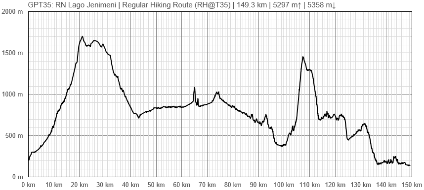
Elevation Profile of Regular Hiking Route
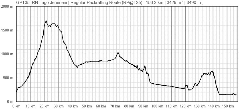
Elevation Profile of Regular Packrafting Route
Section Planning Status
Recommended Travel Period
Benefits of Hiking and Packrafting
Recommended Travel Direction
Section Length and Travel Duration
Suitable Section Combinations
Section Attractiveness
Section Difficulty
Resupply
Resupply Town
Town: Cochrane.
Cochrane is a decently sized town with three mid-range supermarkets. The largest one, which is a grocery and department store, is located adjacent to the town square. There are many lodging and restaurant options. Be sure to withdraw an ample amount of money here because most of the businesses in the next town, Villa O’Higgins, only take cash and there is no ATM.
Shopping: Food
Shopping: Fuel
Shopping: Equipment
Services: Restaurants
Services: Laundry
Services: ATM and Money Exchange
Accommodation: Hostals and Hotels
Accommodation: Cabañas
Accommodation: Camping
Transport: Ground Transport
Transport: Ferries
Transport: Shipping Services
Resupply on the Trail
Location, Names, Available Items and Services
Access to Route and Return
Access to Start
Return from Finish
Escape Options
Permits, Entry Fees and Right-of-Way Issues
Regular Route
Regular Hiking Route
Regular Packrafting Route
- Route description by Kara Davis after Season 2017/18:
Follow 265-CH, a high-speed dirt road, out of Chile Chico. Turn off onto a 4WD track which heads towards a small horse farm. The 4WD track continues up the plateau past the farm. There is very little coverage on the plateau but plenty of flat ground for camping. About 8 km after turning off of 265-CH onto the 4WD track, the route begins the long cross-country journey across an open plateau of tall grass. Occasionally, there is a small trail to follow, but it is probably more efficient to travel cross country in a straight line. See if you can spot any guanacos hiding in the hill or flamingos floating on the small ponds during this section. Try and find the 4WD track which is possible to follow for the last 2 km before the route joins X-753 on the south side of the plateau.
X-753 is a lightly trafficked dirt road surrounded by exposed but very flat land. More trees appear as the route gets closer to Lago Jeinemeni.
Shortly after encountering the sign welcoming you to the Reserva Nacional Lago Jeinimeni, there is a ranger station. The rangers require all hikers to register and pay the park entrance fee (3.000 CLP). For the upcoming trail section (which is a popular and well-marked track), the rangers require you to spend your first night at the Refugio Valle Hermoso, which is approximately 15 km from the beginning of the track. There is a 5.000 CLP fee to camp there which is to be paid at the ranger’s station with the entrance fee. There is also a campsite at the beginning of the track on the shore of Lago Jeinimeni.
The Regular Hiking Route follows a 4WD track along the east and south shores of Lago Jeinimeni. The 4WD track eventually transitions to a single track trail near the outlet of Lago Jeinimeni.
Alternate: After encountering a split in the track marked clearly with wooden signs, take the track towards Valle Hermoso. The rangers informed us the trail that the Regular Packrafting Route follows on the south side of Laguna Esmeralda to Lago Verde was not good.
The route from Laguna Esmeralda to the first pass located just north of Lago Verde is along a rocky river bed and marked with short wooden poles.There are a handful of river crossings which can be dangerous at high flows. An orange pole marks the turn off from the river bed onto the trail leading up to the pass. Ford the river to the pole, and begin the steep, but short climb.
After rounding the northern edge of Lago Verde, the route follows another rocky river valley also marked with wooden poles. Occasionally the route winds into the brush. The Refugio Valle Hermoso is located in the trees south of the river bed and is marked with a wooden sign. No campfires are permitted, but there is a small building with a fireplace, a picnic table, and a latrine.
The route continues for several km along the rocky riverbed with poles and cairns marking the way. Be prepared for several river crossings. About 2 km from the Refugio Valle Hermoso, the route leaves the riverbed and begins climbing up to the second pass. A surprisingly nice trail descends alongside the Avilés River and terminates at Casa Piedra, a stone house at the put-in for the the Río Chacabuco. If wind makes packrafting difficult, it is possible to road walk to Valle Chacabuco along X-83. There is a campsite (8.000 CLP) at Valle Chacabuco as well as a restaurant.
We did not complete the section from Valle Chacabuco to Cochrane and have no knowledge of route conditions.


