GPT31H - Valle Simpson
| All GPT sections (click to show) |
|---|
|
GPT Section Articles
|
Recent Alerts and Suggestions
Season Section Log
- 2022 Feb: 04-05, SoBo, RR, Kris&Stiina
The whole section is a gravel road, except for a few km in the beginning where it is asphalt. We hitched the first 16km and then continued on foot the traffic wasn’t too bad but it wasn’t great for peaceful hiking either, lots of dust eating with every passing car. Chileans do love their fences so everything was well fenced off on both sides of the road for most of the section. We were lucky that some cattle did not agree with the local politics of fencing off the open water and had broken a fence to access the Burgos Lake. Which is where we camped at and had a nice swim. It was right next to the road but bushes helped with making it somewhat private. What they didn’t help that much with was the dust cloud that the passing cars generated, but luckily the traffic was not too bad. The next day we hiked/hitched to the end of the section, as the road was just too boring and we wanted to get on some trails already. Unless you are super into connecting footsteps then we would recommend to just try and get a hitch to the start of next section.
For more stories of the trail, pictures, videos and in case you want to ask us anything you can find us on Instagram: @smallfootprint_bigadventures
Summary Table
| GPT31H: Valle Simpson | Hiking | Packrafting | |||||
| Group | G: Aysen Norte | Total | 36.6 km | 9 h | - | - | |
| Region | Chile: Aysén (XI) | Trails (TL) | - | - | - | - | |
| Start | Coyhaique | Minor Roads (MR) | 20.7 km | 56.6% | - | - | |
| Finish | Villa Frei | Primary Roads (PR) | 15.9 km | 43.4% | - | - | |
| Status | Published & Verified | Cross-Country (CC) | - | - | - | - | |
| Traversable | Sep - May | Bush-Bashing (BB) | - | - | - | - | |
| Packraft | Only Burden | Ferry (FY) | - | - | - | - | |
| Connects to | GPT30H, GPT32 | Investigation (I) | - | - | - | - | |
| Options | 8 km (Variants Only) | Exploration (EXP) | - | - | - | - | |
| Hiking | Packrafting | Total on Water | - | - | |||
| Attraction | 1 (of 5) | - | River (RI) | - | - | ||
| Difficulty | 1 (of 5) | - | Lake (LK) | - | - | ||
| Direction | Both ↓↑ | - | Fjord (FJ) | - | - | ||
| Comment | - | ||||||
| Character | Farmland, Settlers, Road Walking | ||||||
| Challenges | - | ||||||
Satellite Image Map
Elevation Profile
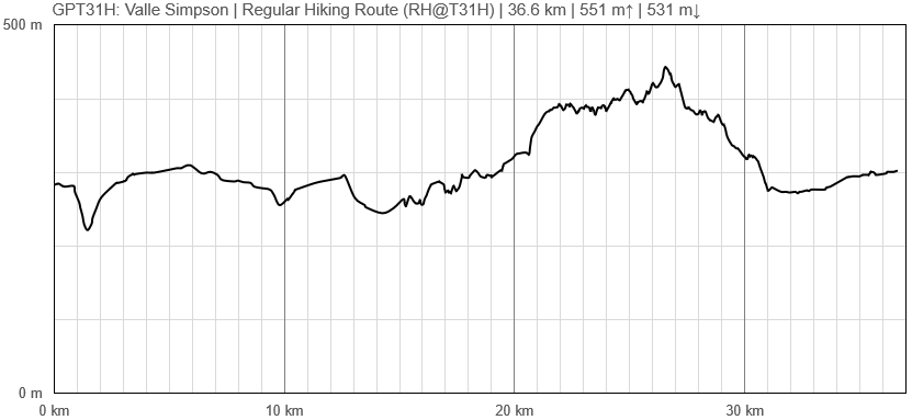
Elevation Profile of Regular Hiking Route
Elevation Profile of Regular Packrafting Route
[[File:|frame|center|Elevation Profile of Regular Hiking Route (2019)]]


