|
|
| Línea 25: |
Línea 25: |
| | }} | | }} |
| | {{Table all GPTs}} | | {{Table all GPTs}} |
| − | ==Section Statistics==
| |
| − | ==Basic statistics==
| |
| − | {| border="1" style="border-collapse:collapse"
| |
| − | |+'''GPT02: Mina El Teniente'''
| |
| − | |style="background-color:#bfbfbf;"|Traversable
| |
| − | |colspan="2"|Jan - Mar (Conditionally: Dec, Apr)
| |
| − | |-
| |
| − | |style="background-color:#bfbfbf;"|Packraft
| |
| − | |colspan="2"|Only Burden
| |
| − | |-
| |
| − | |style="background-color:#bfbfbf;"|
| |
| − | |style="background-color:#bfbfbf;"|Hiking
| |
| − | |style="background-color:#bfbfbf;"|Packrafting
| |
| − | |-
| |
| − | |style="background-color:#bfbfbf;"|Attraction
| |
| − | |style="background-color:#ffbfbf;"| 2 / 5
| |
| − | |style="background-color:#c2edfc;"|No Rating
| |
| − | |-
| |
| − | |style="background-color:#bfbfbf;"|Difficulty
| |
| − | |style="background-color:#ffbfbf;"| 3 / 5
| |
| − | |style="background-color:#c2edfc;"|No Rating
| |
| − | |-
| |
| − | |style="background-color:#bfbfbf;"|Distance
| |
| − | |style="background-color:#ffbfbf;"|100.7 km | 36 h
| |
| − | |style="background-color:#c2edfc;"|100.7 km | 36 h
| |
| − | |-
| |
| − | |style="background-color:#bfbfbf;"|Direction
| |
| − | |style="background-color:#ffbfbf;"|Both ↓↑
| |
| − | |style="background-color:#c2edfc;"|Both ↓↑
| |
| − | |-
| |
| − | |style="background-color:#bfbfbf;"|Comment
| |
| − | |colspan="2"|-
| |
| − | |-
| |
| − | |style="background-color:#bfbfbf;"|Status
| |
| − | |colspan="2"|Published and Verified
| |
| − | |-
| |
| − | |style="background-color:#bfbfbf;"|Zone
| |
| − | |colspan="2"|A: Zona Precordillera
| |
| − | |-
| |
| − | |style="background-color:#bfbfbf;"|Region
| |
| − | |colspan="2"|Chile: Region Metropolitano (V) & O'Higgins (VI)
| |
| − | |-
| |
| − | |style="background-color:#bfbfbf;"|Start
| |
| − | |colspan="2"|El Melocotón
| |
| − | |-
| |
| − | |style="background-color:#bfbfbf;"|Finish
| |
| − | |colspan="2"|Coya
| |
| − | |-
| |
| − | |style="background-color:#bfbfbf;"|Previous Section
| |
| − | |style="background-color:#bfbfbf;"|Next Section
| |
| − | |style="background-color:#bfbfbf;"|Alternative Section
| |
| − | |-
| |
| − | |[[GPT01]]
| |
| − | |[[GPT03]]
| |
| − | |No
| |
| − | |}
| |
| − |
| |
| | ==Recent Alerts and Suggestions== | | ==Recent Alerts and Suggestions== |
| | ==Season Section Log== | | ==Season Section Log== |
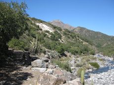
 Estero Coyanco, Cajón del Maipo, beginning of the trek. Photo: Club Andino Patagónico Elal |
|
|
|
|
| Summary (editar)
|
| Activity
|
Trekking
|
| Location
|
Chile, Rancagua
|
| Scenery
|
Mediana
|
| Atractions
|
Vistas panorámicas
|
| Duration
|
días "Días" no está en la lista de valores posibles (3 horas o menos, 1/2 día, 3/4 día, 1 día, 1 día y medio, 2 días, 3 días, 4 días, 5 días, 3 - 5 días, 6 - 7 días, 8 - 10 días, 11 - 14 días, 15 - 20 días, 20 - 25 días, 26 - 35 días, 36 - 60 días, 61 - 89 días, más de 90 días) para esta propiedad.
|
|
|
| Trail
|
Siempre Claro
|
| Signage
|
Inexistente
|
| Infraestructure
|
Inexistente
|
|
|
|
|
| Topology
|
Cruce
|
| Gain/Loss (meters)
|
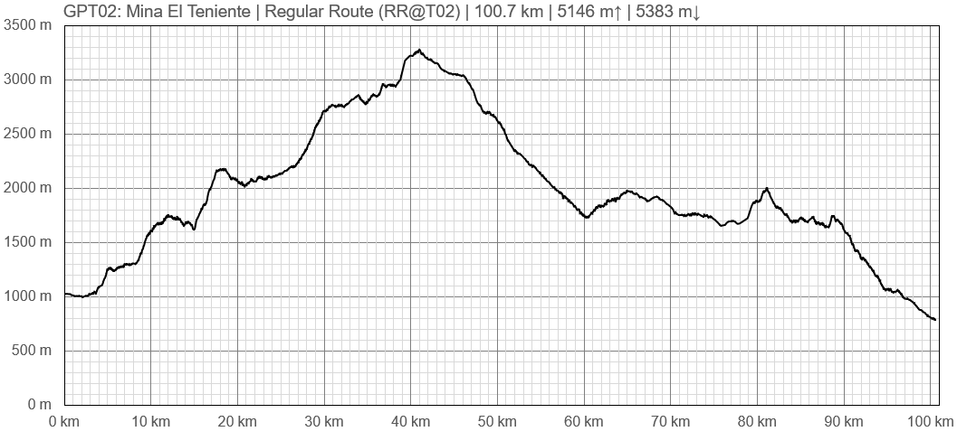
+5146, -5383
|
| Distance (k)
|
100.7
|
|
|
| Skills
|
No requiere
|
| Original creator
|
Jan Dudeck
|
| Download KMZ/GPX
|
Debes registrarte para descargar. Formulario es BREVISIMO
|
|
|
| Para ver estos botones debes registrarte. Toma 30 segundos: es un formulario minusculo, de solo 3 campos obligatorios.
|
|


