Diferencia entre revisiones de «GPT24H - PN Los Alerces Tierra»
(→Summary Table) |
(→Season Section Log) |
||
| Línea 32: | Línea 32: | ||
==Season Section Log== | ==Season Section Log== | ||
| + | * 2020-Jan-13-14 / Shaun / Regular hiking route southbound | ||
| + | |||
| + | This section was a bit better than I expected. Although they were officially closed due to being overgrown, I walked the first 15km of the regular route / Huella Andina and it was fine. In fact, I met two Alceres Park rangers with chain saws putting the finishing touches to a 4km part that was due to reopen the next day. There are many new-ish Huella Andina blue and white trail markers throughout. There were a few other parts of the trail that were closed that I didn’t walk on, but they also may have been passable or about to reopen. And there were a number of other parts that were open and were fine. So it was possible to avoid walking on the road for much of the first 47km. However, the boat service from Punta Mattos to Lago Krugger still does not operate and so I had to walk on the road for the final 20-25km. | ||
| + | |||
| + | The trail to Villa Futalaufquen from Lago Krugger is open for its entire length, not just from Playa Blanco. But, of course, without the Punta Mattos ferry it’s not possible for hikers to cross and start at Lago Krugger, but that trail is another packrafting option. There is a daily boat service from Puerto Limonao (3km north of Villa Futalaufquen) to Lago Krugger that leaves at noon and returns at 7pm. | ||
| + | |||
==Summary Table== | ==Summary Table== | ||
{| border="1" style="border-collapse:collapse" | {| border="1" style="border-collapse:collapse" | ||
Revisión del 12:11 20 ene 2020
| All GPT sections (click to show) |
|---|
|
GPT Section Articles
|
Recent Alerts and Suggestions
- 2019-11-10 / Jan Dudeck
The regular hiking route is according to reports from past years mostly unmaintained. This means hikers must deviate on long stretches to the main road making this section less attractive for hikers. Also the trail from Lago Kruger to Villa Futalaufquen might be unmaintained. Therefore, ask before taking the ferry! The packrafting route GPT24P is unaffected by this issue and remains a highlight if the GPT because its 99% on water.
Season Section Log
- 2020-Jan-13-14 / Shaun / Regular hiking route southbound
This section was a bit better than I expected. Although they were officially closed due to being overgrown, I walked the first 15km of the regular route / Huella Andina and it was fine. In fact, I met two Alceres Park rangers with chain saws putting the finishing touches to a 4km part that was due to reopen the next day. There are many new-ish Huella Andina blue and white trail markers throughout. There were a few other parts of the trail that were closed that I didn’t walk on, but they also may have been passable or about to reopen. And there were a number of other parts that were open and were fine. So it was possible to avoid walking on the road for much of the first 47km. However, the boat service from Punta Mattos to Lago Krugger still does not operate and so I had to walk on the road for the final 20-25km.
The trail to Villa Futalaufquen from Lago Krugger is open for its entire length, not just from Playa Blanco. But, of course, without the Punta Mattos ferry it’s not possible for hikers to cross and start at Lago Krugger, but that trail is another packrafting option. There is a daily boat service from Puerto Limonao (3km north of Villa Futalaufquen) to Lago Krugger that leaves at noon and returns at 7pm.
Summary Table
| GPT24H: PN Los Alerces Tierra | Hiking | Packrafting | |||||
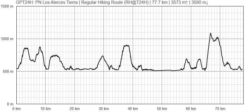
| Group | E: Lagos Argentinos | Total | 68.5 km | 25 h | - | - | |
| Region | Argentina: Chubut | Trails (TL) | 62.4 km | 91.2% | - | - | |
| Start | Villa Lago Rivadavia | Minor Roads (MR) | 2.1 km | 3.0% | - | - | |
| Finish | Villa Futalaufquen | Primary Roads (PR) | 4.0 km | 5.8% | - | - | |
| Status | Published & Verified | Cross-Country (CC) | - | - | - | - | |
| Traversable | Nov - Apr (Maybe: Sep, Oct, May) | Bush-Bashing (BB) | - | - | - | - | |
| Packraft | Only Burden | Ferry (FY) | (9.2 km) | (11.9%) | - | - | |
| Connects to | GPT23, GPT24P, GPT25H, GPT25P | Investigation (I) | - | - | - | - | |
| Options | 71 km (1 Options & Variants) | Exploration (EXP) | - | - | - | - | |
| Hiking | Packrafting | Total on Water | - | - | |||
| Attraction | 2 (of 5) | - | River (RI) | - | - | ||
| Difficulty | 2 (of 5) | - | Lake (LK) | - | - | ||
| Direction | Both ↓↑ | - | Fjord (FJ) | - | - | ||
| Comment | - | ||||||
| Character | Forest, Settlers, Road Walking, Partly Overrun | ||||||
| Challenges | Bush Bashing | ||||||


