Diferencia entre revisiones de «GPT05 - Río Colorado»
(→Season Section Log) |
(→Season Section Log) |
||
| Línea 36: | Línea 36: | ||
7 nights 8 days for us. Super tough section. The entire area around Rio Colorado is extremely challenging; down & up. We went the alternate route to the Hot Springs. (OH-CC-A@05-C-#001). I was tough with multiple steep gullies, then we got there to see the hot springs were COLD. Then the optional hike to | 7 nights 8 days for us. Super tough section. The entire area around Rio Colorado is extremely challenging; down & up. We went the alternate route to the Hot Springs. (OH-CC-A@05-C-#001). I was tough with multiple steep gullies, then we got there to see the hot springs were COLD. Then the optional hike to | ||
Re connect with the RR from the hot springs (OH-CC-A@05-E-#002) was completely impassable. I didn’t go all the way up to the canyon wall. All I could see were route that would take some serious climbing. We had to down climb and take the lower route to climb up again. Property dispute near Volcan Mondaco had no problems. Quiet and didn’t seem like anybody was there for us. Parque Inglés - Molina Bus leaves at 7 am on the weekdays, we hitchhiked. | Re connect with the RR from the hot springs (OH-CC-A@05-E-#002) was completely impassable. I didn’t go all the way up to the canyon wall. All I could see were route that would take some serious climbing. We had to down climb and take the lower route to climb up again. Property dispute near Volcan Mondaco had no problems. Quiet and didn’t seem like anybody was there for us. Parque Inglés - Molina Bus leaves at 7 am on the weekdays, we hitchhiked. | ||
| + | |||
| + | *2019-Dec-17 / Matus & Anna / Regular SOBO and Optional to meet optional start of GPT06 | ||
| + | It took us 7 days including 1 zero due to bad weather. | ||
| + | I agree with everything what was written in previous updates for GPT05. Cross country sections were difficult, but in some of them we managed to find old unused trails which worked for us. | ||
| + | River crossings - Rio Claro in the afternoon was ok. Rio Negro in the afternoon was REALLY challenging, almost not doable. After hour of trying we managed to find one spot we could cross. I wouldn't want to cross Rio Colorado without that bridge at any time. | ||
| + | Optional trail to meet optional start of section 6 was fine in the valley. Problem was to connect it to the climb. We had to climb very steep slope to get there. From that point trail was in good condition. | ||
==Summary Table== | ==Summary Table== | ||
Revisión del 09:24 18 dic 2019
| All GPT sections (click to show) |
|---|
|
GPT Section Articles
|
Recent Alerts and Suggestions
- 2018-Dec / Martin Lizondo / Regular Route Southbound
Volcán Planchón Peteroa in "alerta amarilla", so passing is not allowed. I had to skip the section and continue GPT6 from Puente Inglés.
Season Section Log
- 2019-Dec-8 / Martina & Ivo / Regular route southbound
Six (hard) days for this section. After the first pass there was a tiny snowfield to cross, nothing to worry about. River crossings didn't cause any problems. The bridge Puente Las Yeguas was in excellent condition. The navigation through the cross country parts was quite demanding and took us a lot of time. Right of way conflict before the Laguna Mondaca: The whole valley is private property and belongs to a guy who comes by helicopter for fly fishing at the weekends. His guards spotted us several hours before we arrived at their puesto but welcomed us very friendly and explained everything. They let us camp at the Estero del Volcan. At Parque Ingles we found food and accommodation. There is a bus to Molina (for schedule see section "Access to route").
- 2019-Dec 9 / Ty & America / RR SOBO
7 nights 8 days for us. Super tough section. The entire area around Rio Colorado is extremely challenging; down & up. We went the alternate route to the Hot Springs. (OH-CC-A@05-C-#001). I was tough with multiple steep gullies, then we got there to see the hot springs were COLD. Then the optional hike to Re connect with the RR from the hot springs (OH-CC-A@05-E-#002) was completely impassable. I didn’t go all the way up to the canyon wall. All I could see were route that would take some serious climbing. We had to down climb and take the lower route to climb up again. Property dispute near Volcan Mondaco had no problems. Quiet and didn’t seem like anybody was there for us. Parque Inglés - Molina Bus leaves at 7 am on the weekdays, we hitchhiked.
- 2019-Dec-17 / Matus & Anna / Regular SOBO and Optional to meet optional start of GPT06
It took us 7 days including 1 zero due to bad weather. I agree with everything what was written in previous updates for GPT05. Cross country sections were difficult, but in some of them we managed to find old unused trails which worked for us. River crossings - Rio Claro in the afternoon was ok. Rio Negro in the afternoon was REALLY challenging, almost not doable. After hour of trying we managed to find one spot we could cross. I wouldn't want to cross Rio Colorado without that bridge at any time. Optional trail to meet optional start of section 6 was fine in the valley. Problem was to connect it to the climb. We had to climb very steep slope to get there. From that point trail was in good condition.
Summary Table
| GPT05: Río Colorado | Hiking | Packrafting | |||||
| Group | B: Zona Arrieros | Total | 112.2 km | 40 h | - | - | |
| Region | Chile: Maule (VII) | Trails (TL) | 64.1 km | 57.1% | - | - | |
| Start | Los Queñes | Minor Roads (MR) | 19.2 km | 17.1% | - | - | |
| Finish | Radal | Primary Roads (PR) | - | - | - | - | |
| Status | Published & Verified | Cross-Country (CC) | 28.9 km | 25.8% | - | - | |
| Traversable | (Maybe: Dec, Jan, Feb, Mar, Apr) | Bush-Bashing (BB) | - | - | - | - | |
| Packraft | Only Burden | Ferry (FY) | - | - | - | - | |
| Connects to | GPT04, GPT06 | Investigation (I) | - | - | - | - | |
| Options | 190 km (4 Options & Variants) | Exploration (EXP) | - | - | - | - | |
| Hiking | Packrafting | Total on Water | - | - | |||
| Attraction | 3 (of 5) | - | River (RI) | - | - | ||
| Difficulty | 6 (of 5) | - | Lake (LK) | - | - | ||
| Direction | Both ↓↑ | - | Fjord (FJ) | - | - | ||
| Comment | - | ||||||
| Character | Forest, Alpine Terrain, Volcanic Terrain, Summit Ascents, Mountain Pastures, Arrieros, Unpeopled Areas | ||||||
| Challenges | Demanding River Fords, Exposure to Elements, Clambering, Demanding Navigation, Resupply Distance, Possibly Impassable, Right-of-Way Disputes | ||||||
Satellite Image Map
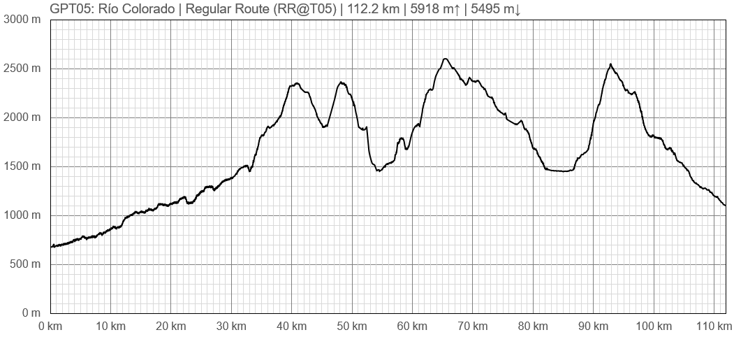
Elevation Profile
Section Planning Status
Recommended Travel Period
Benefits of Hiking and Packrafting
Recommended Travel Direction
Section Length and Travel Duration
Suitable Section Combinations
Section Attractiveness
Section Difficulty
Resupply
Resupply Town
Shopping: Food
Shopping: Fuel
Shopping: Equipment
Services: Restaurants
Services: Laundry
Services: ATM and Money Exchange
Accommodation: Hostals and Hotels
Accommodation: Cabañas
Accommodation: Camping
Transport: Ground Transport
Transport: Ferries
Transport: Shipping Services
Resupply on the Trail
Location, Names, Available Items and Services
Access to Route and Return
Access to Start
Return from Finish
2019-Dec-8
Monday to Thursday
Molina-Radal: 17:00
Radal-Molina: 07:30
Friday
Molina-P.Ingles: 17:00
Radal-Molina: 07:30
Saturday
Molina-P.Ingles: 11:30 / 13:30
P.Ingles-Molina: 18:00
Sunday
Molina-P.Ingles: 09:00
P.Ingles-Molina: 15:30 / 17:00


