ENG:Caleu - Olmué
|
|
|
| |||||||||||||||||||||||||||||||||||||||||||||||||||
Época adecuada
Todo el año. Ideal a finales de mayo y principios de junio, cuando los robles están de color rojo intenso.
Acceso
En auto

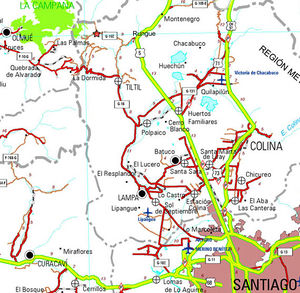
Desde Santiago, se debe tomar la carretera panamericana (ruta 5) en dirección al norte. El desvío a Rungue está en el kilómetro 54. Se debe tomar esa salida (indicada por un cartel de "RUNGUE RETORNO" porque sirve para ambas cosas) y entrar al pueblo. Donde termina la calle por la que venimos, se debe doblar a la izquierda y, pocos metros más adelante, a girar a la derecha (se acaba la calle de todos modos) para cruzar la linea ferrea y luego un puente sobre un estero. Inmediatamente después de cruzado el estero, se debe girar a la izquierda, y comenzar a bordear el estero por un camino de asfalto. Se bordeará luego el embalse Rungue. Tras 3,9 kilómetros desde la panamericana y justo después de cruzar un puente pequeño, surge un desvío a la derecha ("A Caleu"), el que se debe tomar. Este camino está pavimentado también, pero es muy angosto, por lo que se debe tener mucha precaución en las curvas. El camino se interna por el valle y asciende progresivamente. Aproximadamente en el kilómetros 11 desde el desvío (14,9 desde la panamericana) se ha llegado a Caleu y surge una bifurcación: debe tomarse la izquierda, que sigue subiendo ladera arriba. 970 metros más arriba, muy poco antes del paso hacia el valle de Olmué, se encuentra la caseta de cobro y el portón desde donde surge el camino la cumbre del cerro El Roble a mano derecha.
Nota: También es posible llegar a Caleu desde Til-Til, para lo cual se debe dejar la carretera panamericana en un desvío anterior, pero resulta más rápido la variante por Rungue descrita más arriba.
En transporte público
Existen tres recorridos únicos que van desde Tiltil a Caleu, que salen desde el supermercado Unimarc. En primer lugar se debe tomar un bus desde Santiago en el terminal la Paz, cerca del metro Cal y canto con dirección a Tiltil. Por medio de transporte publico sólo es posible asistir los sábados, dado los horarios de ingreso del Santuario. Para esto se debe tomar el bus que sale a las 10 am del supermercado Unimarc de Tiltil, estarán llegando al rededor de las 10:30 hrs a la entrada del santuario(el horario de ingreso es hasta las 12). Para regresar se puede tomar un bus que pasa a las 17:30 hrs desde Caleu a Tiltil por el mismo camino principal.
Descripción de la ruta

From the access gate to El Roble, at 1242 meters above sea level, it is recommended to continue driving 4.1 kilometers further, up to 1680 meters above sea level, on the edge that divides the Caleu and Olmué valleys. To the west, there are beautiful views of the palmar of Ocoa and La Campana. Shortly after this first view of the Olmué valley, a pedestrian fork appears for the path that leads to Ocoa (1680 masl and highest point of the route). It's the parking point. Turn left, heading west. (For the top of the Oak you must continue on the main vehicular road, through the route described in Cerro el Roble (vehicular route)). The route is wide and pleasant, in the shadow of the northernmost oaks of the Southern Hemisphere, and it enters with a gentle slope along the southern slope of the edge that separates the two valleys.
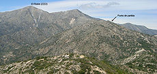
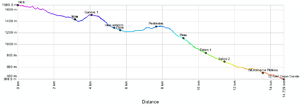
After 2.3 kilometers, the footprint is passed to the northern slope of this edge, with more sun exposure, and the vegetation will flatten suddenly, disappearing oaks, but getting in return a beautiful view of the palmar of Ocoa at our feet. One more kilometer should be traveled along this wide route until it empties into an old quartz mine (on the southern slope). (If you turn right, you will cross the route Caleu - Ocoa). It is at this point that the "wild" stretch of the route begins, along the Cordon de los Penitentes, because there is no clear path along a long stretch. You must continue along the edge, ascending through the bushes and rocks. There are some faint traces of animals, but in general there is no well-defined trail, so the slogan is "always on the edge", along an old pirca that crowns most of the route. After 15 minutes you reach a summit (marked as "summit 1") from where you can see the route ahead.
The next section is somewhat more confusing, because the edge becomes less clear. It is recommended to follow the pirca, which turns a few meters towards the south. Then we must move again towards the west, with the aim of retaking the edge, which becomes visible again. To do this, you must go down a quite hostile slope, between bushes, some of them thorny. Shortly before reaching the lowest part, a path that comes from the south, from Olmué (marked as "trail start") is reached which must be followed. The walk acquires a more friendly character again. 35 meters further on, a plain surrounded by trees is reached. Shortly after, the ascent to the rocky Penitentes hill starts, the last stumbling block of the route. The path will be clear for a long time, ascending gradually. The final stretch before the Penitentes, the footprint and the pirca disappear (after all, the Penitentes is a natural stone) and access must be sought between the bushes. The last section before the summit requires helping with the hands to climb the rocks, but it is not a serious difficulty nor does it justify the use of ropes, although the vegetation makes the ascent somewhat difficult. The summit of the Penitentes is a beautiful viewpoint of the route that we have been following, as well as of the two valleys that the cord separates. The section immediately following is the most complicated part of the route, since one should look for a passage between the dense thorny vegetation of the northern slope (the southern slope is a small precipice) and the large rocks. But finding the way is possible, and then there is a tenuous path that continues with some clarity along the arista same until the Ocoa Pass, the lowest point of the edge, and point at which this route connects with the La Campana National Park Crossing.
Here there are three options: you can choose to go down to the south, and go by Granizo or Cajón Grande (as described in this review) which takes about 1h 45 ', or you can go down to the north, towards Ocoa, which takes about 2h 30 ', and for which you should read the respective section in Traverse of La Campana National Park. If it is low towards the south (by either of the two routes) you can go through a leafy forest of languages, peumos, liters and quillayes and there is an Olmué, closer to Santiago and with buses every hour to Santiago. If it is low towards the north, you can go through a singular Palmar, and you have found a CONAF, where there is no mobilization, and then an Ocoa and the Pan-American Highway (with many buses but that do not necessarily stop on the way). Descent to the south '
- A Hail: Described in La Campana National Park Crossing. This point is closer to the town of Olmué.
- A Cajon Grande: The sign at the beginning indicates 5.5 kilometers of walk from Paso Ocoa. The route is always very clear, although narrow, in the shade of the dense vegetation of the ravine (from which it receives its name). At the beginning, it goes down abruptly, zigzagging. Then the slope decreases, and the estuary of the stream must be crossed several times. After 1h30 'of march a branch is reached. Take the left, and continue on a very wide path (if you take the right, you will follow the path Plateu ). Only 15 minutes later, CONAF is reached, where there is parking. If you walk 15 more minutes on the vehicular road, you will reach a bus stop where it is possible to take buses to Olmué.
Expected time
Between six and seven hours from the parking described. The reference of the first author is 4h 30 'until the end of the edge (Paso Ocoa) and 1h 45' from this point to CONAF of Cajón Grande or Olmué. Add 30 to 40 minutes if you start walking from the oak entrance control in Caleu.
Permits / Rates
- You must cancel $ 4000 (US$ 6.5 as of May 2018) per adult to enter (free children). The entrance is administered by the Association of Communes Chapel of Caleu, and is open weekends and holidays from 9 a.m. to 1:00 p.m. In case of going one business day and wanting to cross the gate by car, you should call the cell phone +56984759457 or +56962382245.
Recommendations
- Checklist: Aunque sepas perfectamente lo que debes llevar, es preferible chequearlo al empacar. Esta ruta ha sido clasificada como Type 1 equipment checklist: low altitude route, without camping, snow or cold.
- Going back to the car can be quite complicated if left at the very beginning of the trail. Even more so considering that the Oak access door closes at 6:00 pm. If you go by car, it is best to leave at least before the door. However, if you do not have a generous soul willing to go to the starting point, it is best to make this route by public transport.
Weather forecast
- Meteochile Region of Valparaíso
- Accuweather Valparaíso
- Accuweather Viña del Mar
- Meteochile Metropolitan Region
- Accuweather Santiago
- Accuweather Puente Alto
Horseback riding in La Campana National Park
To hire horses in the La Campana National Park, it is possible to contact Marco at +56967348561 and +56332271996. Marco Cobra $ 4,000 / hour per horse $ 4000 (US$ 6.5 as of May 2018). In two to three hours you can walk quite well the main forests of palms, and in three to five hours you can reach the waterfall and other points of interest of the park.
Hire guided tours and excursions
- Denomades.com: Tours y trekkings regulares y privados en el Cajón del Maipo y otros destinos. Contacto directo con los mejores operadores locales.
- Contacto: reservas@denomades.com
- Teléfono: +56 229551857
- Facebook: Denomades.com
Photo Geology
- Caleu - Olmue by the Cord of the Penitentes.JPG
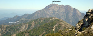
Almost complete view of the crossing Caleu - Olmué by the Cord of the Penitentes from the summit of Cerro La Campana. December 2016


