GPT08 - Volcán Chillan
|
|
|
| |||||||||||||||||||||||||||||||||||||||||||||||||||||
Recent Alerts and Suggestions
- 2019-Nov-10 / Jan Dudeck
Volcan Chillán remains active. The regular route passes the crater closely therefore Option 1 appears currently the saver if someone does not want skip section GPT08 completely. This option passes the danger zone with more distance. In case of an eruption volcanic ash is likely to affect Option 1 but the risk of direct volcanic effects is lower (flash flood from melting snow and glaciers, land slides, lava and flying rocks).
- 2019-Jan-13 / Martin Lizondo / Regular Route Southbound
Volcán Chillán was in "alerta naranja".
Río Ñuble impassable at S36° 50.188' W71° 14.935' Better continue following the minor road in the alternative route.
When hiking the alternative east route (Paso Aguila) do not descend to the valley at S36° 57.919' W71° 14.752'. It's unmantained and overgrounded, because of recent forest fires. Better stay above the tree line until Laguna El Lobo.
Season Section Log
- 2020-Jan-02 / Martina & Ivo / Regular route southbound (and optional hike along Laguna de la Laja)
6 days from Los Sauces to Abanico.
Los Sauces: If you tell the bus driver you want to cross the river by cable car (carro azul) he honks at the bus stop and señor Marcial comes from the other side to get you.
Ford Rio Ñuble: If you are a dwarf like me, you should ask your taller hiking partner to carry your backpack, otherwise it will get wet. Demanding.
Volcan Chillan: PLEASE NOTE: We were absolutely aware that our buddy Volcano could erupt or explode at ANY GIVEN MOMENT and that this was NOT a SAFE option to hike. (But it was beautiful! ...and a bit overgrown in some places. There is not much of the trail left before the first pass.)
Laguna de la Laja: It was beautiful but we definitively wouldn't recommend it. There is no trail along the Laguna. At the beginning you can walk on cow tracks close to the waterfront. Afterwards it's 15 km of cross country. The 3 km into the third inlet took us 3 hours and were really dangerous because of loose rocks and steep cliffs. The following investigation part (@08-04-#002) was mainly a quite nice trail, but we lost it twice and it took us ages to find it again, and in this steep and not very easy terrain you don't want to loose the trail. We were really glad when we got back to the regular route.
From Abanico there are several buses per day going directly to Los Angeles. Resupply in Abanico is possible.
- 30-Dec-2019 / Matus & Anna / SOBO through Optional 1
It took us 5 days. We had to register in Carabinieros. They didn't have a problem with leting us go even regular route, seemed like eventual crossing to Argentina is their primary issue. Optional 1 - to the juction with valley walk without problem. Cross coutry part on the ridge was easy to navigate. On downhill there is no trail so we went crosscountry again. It's bit overgrown in some spots, we found trail cca after half of descend. Last flowing water is before juction with valley walk. We saw some water holes cca 2-3km before Laguna de Lobo. Rest of the regular trail - cross coutry sections were demanding. Otherwise no problem. We got hitch to Los Angeles after CONAF station so no idea about resuply or accomodation.
Summary Table
| GPT08: Volcán Chillan | Hiking | Packrafting | |||||
| Group | B: Zona Arrieros | Total | 140.1 km | 47 h | 134.3 km | 43 h | |
| Region | Chile: Bío Bío (VIII) | Trails (TL) | 80.1 km | 57.2% | 56.6 km | 42.1% | |
| Start | Puente Ingles | Minor Roads (MR) | 41.9 km | 29.9% | 39.5 km | 29.4% | |
| Finish | Abanico | Primary Roads (PR) | 8.7 km | 6.2% | 9.5 km | 7.1% | |
| Status | Published & Verified | Cross-Country (CC) | 9.4 km | 6.7% | 5.8 km | 4.3% | |
| Traversable | Jan - Mar (Maybe: Dec, Apr) | Bush-Bashing (BB) | - | - | - | - | |
| Packraft | Useful | Ferry (FY) | - | - | - | - | |
| Connects to | GPT07, GPT09 | Investigation (I) | - | - | - | - | |
| Options | 271 km (6 Options & Variants) | Exploration (EXP) | - | - | - | - | |
| Hiking | Packrafting | Total on Water | 22.8 km | 17.0% | |||
| Attraction | 5 (of 5) | 5 (of 5) | River (RI) | - | - | ||
| Difficulty | 4 (of 5) | 4 (of 5) | Lake (LK) | 22.8 km | 17.0% | ||
| Direction | Both ↓↑ | Both ↓↑ | Fjord (FJ) | - | - | ||
| Comment | - | ||||||
| Character | Forest, Alpine Terrain, Volcanic Terrain, Summit Ascents, Hot Springs, Mountain Pastures, Arrieros | ||||||
| Challenges | Demanding River Fords, Exposure to Elements, Clambering, Resupply Distance | ||||||
Satellite Image Map
Elevation Profile
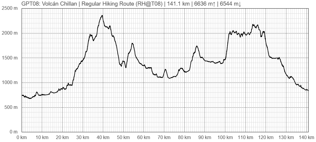
Elevation Profile of Regular Hiking Route
Elevation Profile of Regular Packrafting Route
Section Planning Status
Recommended Travel Period
Benefits of Hiking and Packrafting
Recommended Travel Direction
Section Length and Travel Duration
Suitable Section Combinations
Section Attractiveness
Section Difficulty
Resupply
Resupply Town
Shopping: Food
Shopping: Fuel
Shopping: Equipment
Services: Restaurants
Services: Laundry
Services: ATM and Money Exchange
Accommodation: Hostals and Hotels
Accommodation: Cabañas
Accommodation: Camping
Transport: Ground Transport
Transport: Ferries
Transport: Shipping Services
Resupply on the Trail
Location, Names, Available Items and Services
Access to Route and Return
Access to Start
Bus from San Fabian to Puete Ingles at 6 p.m. in front of the carabinieros. Doesn't run on Sundays and Holidays. (2019-Dec-24)


