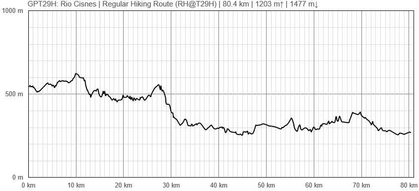
GPT29H (Rio Cisnes)
Add a new log entry always on top in the appropriate season sub-chapter and use format:
* Start Date to Finish Date (use Format YYYY-MMM-DD) / Duration in Days / Hiking or Packrafting / Travel Direction (SOBO for Southbound or NOBO Northbound) / Chosen Route and/or Option Name (RR for Regular Route) / Names or Alias
Summary with remarks to route that are considered useful for other hikers and packrafters. Include alerts, suggestions and personal perception of attractiveness and difficulties.
Add a sub-chapter by placing two "=" before and after the new sub-chapter heading ('==Sub-Chapter Heading==').
Section Log, Alerts and Suggestions
Season 2025/26
Season 2024/25
Season 2023/24
Season 2022/23
- 2023-Mar-18 to 2023-Mar-19 / 2 days / Hiking / SOBO / RR / Martin & Helena
A little more than we expected, there are some nice spots on the way, like Laguna Las Torres.
- 2022 19 Nov Frank 2.5 days SOBO
I got the bus from Villa Amengual to La Tapera then walked back, camped 1 night along the way. Few opportunities for camping as you approach the Carratera Austral as the land is fenced off. Villa Amengual, which is 2KM off route on the Carratera Austral is a good base. On the third day I continued along the Carratera Austral to the junction with the X421 dirt road going to El Gato, a better place to break the journey as there is nothing at the end of stage 29. At the X421 junction there is a bus stop (very few buses) & I hitched from there to Villa Manihuales.
Season 2021/22
Season 2020/21
Season 2019/20
Season 2018/19
Season 2017/18
Season 2016/17
Resupply and Accommodation
Resupply and Accommodation in nearby Towns
Resupply and Accommodation along the Route
Transport to and from Route
Permits, Entry Fees and Right-of-Way Issues
Links to other Resources
Retired Section Article GPT29H - Rio Cisnes
Images
[[Archivo: | ]]
| GPT29H: Rio Cisnes | Hiking | Packrafting | |||||
| Group | G: Aysen Norte | Total | 80.4 km | 19 h | - | - | |
| Region | Chile: Aysén (XI) | Trails (TL) | - | - | - | - | |
| Start | La Tapera | Minor Roads (MR) | - | - | - | - | |
| Finish | Carretera Austral (Camino Picaflor) | Primary Roads (PR) | 80.4 km | 100.0% | - | - | |
| Status | Published & Verified | Cross-Country (CC) | - | - | - | - | |
| Traversable | Sep - May | Bush-Bashing (BB) | - | - | - | - | |
| Packraft | Only Burden | Ferry (FY) | - | - | - | - | |
| Connects to | GPT28H, GPT30H | Investigation (I) | - | - | - | - | |
| Options | None | Exploration (EXP) | - | - | - | - | |
| Hiking | Packrafting | Total on Water | - | - | |||
| Attraction | 1 (of 5) | - | River (RI) | - | - | ||
| Difficulty | 1 (of 5) | - | Lake (LK) | - | - | ||
| Direction | Both ↓↑ | - | Fjord (FJ) | - | - | ||
| Comment | - | ||||||
| Character | Valdivian Rain Forest, Farmland, Settlers, Road Walking | ||||||
| Challenges | - | ||||||

