GPT08 - Volcán Chillan
|
|
|
| |||||||||||||||||||||||||||||||||||||||||||||||||||||
Recent Alerts and Suggestions
- 2019-Nov-10 / Jan Dudeck
Volcan Chillán remains active. The regular route passes the crater closely therefore Option 1 appears currently the saver if someone does not want skip section GPT08 completely. This option passes the danger zone with more distance. In case of an eruption volcanic ash is likely to affect Option 1 but the risk of direct volcanic effects is lower (flash flood from melting snow and glaciers, land slides, lava and flying rocks).
- 2019-Jan-13 / Martin Lizondo / Regular Route Southbound
Volcán Chillán was in "alerta naranja".
Río Ñuble impassable at S36° 50.188' W71° 14.935' Better continue following the minor road in the alternative route.
When hiking the alternative east route (Paso Aguila) do not descend to the valley at S36° 57.919' W71° 14.752'. It's unmantained and overgrounded, because of recent forest fires. Better stay above the tree line until Laguna El Lobo.
Season Section Log
- 2021-Dec-15/ RR NoBo/Marc Anthony
5.5 days Beautiful view of volcán Antuco when walking up towards the ridge line by Laguna Laja and a staying at Los Peucos camping site was a big highlight on my journey on the GPT. Had my dinner in their wonderful hot spring while staring at the clear starlit sky in the cool night. Two nice guys working here and they even donated me some pasta, fruits and vegetables. Walking near the active Chillán Volcano and watching the fumaroles while being circled by a group of condors was also a cool experience.
With that said, this section kicked my ass. Mainly due to some bad fitting shoes I recently bought in Los Ángeles and because I suffered from bad chafing in my butt which made me walk like I had shit my pants for a couple of days. This combined with some tough terrain (specially near Laguna Laja) and countless of horseflies made this section quite challenging for me. But definitely worth it!
Like mentioned by hikers in the previous years fording Rio Ñuble can be a bit demanding especially for shorter people. It was getting late when I reached the river so I decided to camp nearby and cross the river in the morning. Had water up to the balls (i’m 189cm) and the current a bit strong but it was not too bad. Hitched a ride from Puente El Ingles to San Fabian and later jumped on a bus to Chillán to buy new shoes once again. Room with private bathroom for 15.000 at hostal El Molino in San Fabian, nice lady who owns the place.

- Start Date: January 4, 2020
- Section: GPT 8 Southbound
- Duration: 6 Days
- Name/Alias: Ian Hikes + Tobias
- Overview: This section takes you thru some remote areas around the Chillan Volcano region. This section has many hot springs and thermal activity as the volcano is very active these days. This section is longer, and we went a few days at a time without seeing people. The tall jagged mountains make many of the canyons hard to access along with the many parks and reserves. The lower half has you walking around Laguna Laja across the ridgeline which offers amazing views in all direction later giving way to spectacular views of volcan antuco
- Difficulties: Difficult terrain, lots of vertical gain and very remote. Also lots of route finding and cross country above the tree line and big mountain passes. Resupply distance.
- Highlights: Hot Springs!! (The most amazing hot springs I have ever visited in my life) Beautiful mountain passes, great views in all directions and especially of volcan Chillan and Antuco
- Please feel free to reach out to me with any questions at ultratrailca@gmail.com
- 2020-Jan-20 / Martin / Optionsl start south OH 08 - 02 SOBO/ 3.5 days
3.5 days. Solo. Because I was not allowed to walk close to the Volcanoe by the carabineros, following the RR, had to take the optional start south OH 08 - 02, in Nevados de Chillán Ski Resort. Funny enough, I walked the first day across the volcanoe anyway, it had some smoke coming out but nothing dangerous happened. Then followed RR to the end. Cross country segments in the ridge close to Laguna del Laja were demanding and not ideal for a solo hiker. But it was worth the effort, one of the most amazing views I have seen so far. Beautiful section. Resupplied and stayed for one night in Abanico.
- 2020-Jan-05 /Ty & America / RR SOBO/ 3 days
Can ford river @ los sauces easily rather than walking from Puente Ingles. Cable Car was all Locked up. Registration @ El Roble like the others. We camped at the hot rivers close to Volcan Chillan and I fucked up with the gasoline in my stove. Buzzkill...: but Fortunately there was an exit to Termas De Chillan close. We got rides easily from the road.
- 2020-Jan-03 / Maddie & Tom / Regular Route Southbound
4.5 days. Starting at El Ingles and hiking southbound towards Abanico. Lovely section however can be slow at times when the track is hard to follow. We had to register with the Carabineros at El Roble. Before crossing Rio Nuble there is a large gate with ‘private property: no entry’ written on it. We found this off putting. The river crossing itself was fine in the early morning but could be challenging without trekking poles and with a very heavy pack. After the Laguna de La Laja the track becomes especially more challenging and rocky. In poor weather it could be dangerous given the slippery slopes and steep descents. We honestly found this section harder than GPT06 and would swap the difficulty ratings. Took a bus into Los Angeles at 5pm to resupply for the next section. Did not investigate Abanico as we caught the bus as it was leaving.
- 2020-Jan-02 / Martina & Ivo / Regular route southbound (and optional hike along Laguna de la Laja)
6 days from Los Sauces to Abanico.
Los Sauces: If you tell the bus driver you want to cross the river by cable car (carro azul) he honks at the bus stop and señor Marcial comes from the other side to get you.
Ford Rio Ñuble: If you are a dwarf like me, you should ask your taller hiking partner to carry your backpack, otherwise it will get wet. Demanding.
Volcan Chillan: PLEASE NOTE: We were absolutely aware that our buddy Volcano could erupt or explode at ANY GIVEN MOMENT and that this was NOT a SAFE option to hike. (But it was beautiful! ...and a bit overgrown in some places. There is not much of the trail left before the first pass.)
Laguna de la Laja: It was beautiful but we definitively wouldn't recommend it. There is no trail along the Laguna. At the beginning you can walk on cow tracks close to the waterfront. Afterwards it's 15 km of cross country. The 3 km into the third inlet took us 3 hours and were really dangerous because of loose rocks and steep cliffs. The following investigation part (@08-04-#002) was mainly a quite nice trail, but we lost it twice and it took us ages to find it again, and in this steep and not very easy terrain you don't want to loose the trail. We were really glad when we got back to the regular route.
From Abanico there are several buses per day going directly to Los Angeles. Resupply in Abanico is possible.
- 30-Dec-2019 / Matus & Anna / SOBO through Optional 1
It took us 5 days. We had to register in Carabinieros. They didn't have a problem with leting us go even regular route, seemed like eventual crossing to Argentina is their primary issue. Optional 1 - to the juction with valley walk without problem. Cross coutry part on the ridge was easy to navigate. On downhill there is no trail so we went crosscountry again. It's bit overgrown in some spots, we found trail cca after half of descend. Last flowing water is before juction with valley walk. We saw some water holes cca 2-3km before Laguna de Lobo. Rest of the regular trail - cross coutry sections were demanding. Otherwise no problem. We got hitch to Los Angeles after CONAF station so no idea about resuply or accomodation.
Summary Table
| GPT08: Volcán Chillan | Hiking | Packrafting | |||||
| Group | B: Zona Arrieros | Total | 140.1 km | 47 h | 134.3 km | 43 h | |
| Region | Chile: Bío Bío (VIII) | Trails (TL) | 80.1 km | 57.2% | 56.6 km | 42.1% | |
| Start | Puente Ingles | Minor Roads (MR) | 41.9 km | 29.9% | 39.5 km | 29.4% | |
| Finish | Abanico | Primary Roads (PR) | 8.7 km | 6.2% | 9.5 km | 7.1% | |
| Status | Published & Verified | Cross-Country (CC) | 9.4 km | 6.7% | 5.8 km | 4.3% | |
| Traversable | Jan - Mar (Maybe: Dec, Apr) | Bush-Bashing (BB) | - | - | - | - | |
| Packraft | Useful | Ferry (FY) | - | - | - | - | |
| Connects to | GPT07, GPT09 | Investigation (I) | - | - | - | - | |
| Options | 271 km (6 Options & Variants) | Exploration (EXP) | - | - | - | - | |
| Hiking | Packrafting | Total on Water | 22.8 km | 17.0% | |||
| Attraction | 5 (of 5) | 5 (of 5) | River (RI) | - | - | ||
| Difficulty | 4 (of 5) | 4 (of 5) | Lake (LK) | 22.8 km | 17.0% | ||
| Direction | Both ↓↑ | Both ↓↑ | Fjord (FJ) | - | - | ||
| Comment | - | ||||||
| Character | Forest, Alpine Terrain, Volcanic Terrain, Summit Ascents, Hot Springs, Mountain Pastures, Arrieros | ||||||
| Challenges | Demanding River Fords, Exposure to Elements, Clambering, Resupply Distance | ||||||
Satellite Image Map
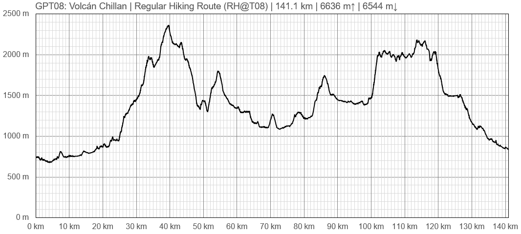
Elevation Profile
Elevation Profile of Regular Hiking Route
Elevation Profile of Regular Packrafting Route
Section Planning Status
Recommended Travel Period
Benefits of Hiking and Packrafting
Recommended Travel Direction
Section Length and Travel Duration
Suitable Section Combinations
Section Attractiveness
Section Difficulty
Resupply
Resupply Town
Shopping: Food
Shopping: Fuel
Shopping: Equipment
Services: Restaurants
Services: Laundry
Services: ATM and Money Exchange
Accommodation: Hostals and Hotels
Accommodation: Cabañas
Accommodation: Camping
Transport: Ground Transport
Transport: Ferries
Transport: Shipping Services
Resupply on the Trail
Location, Names, Available Items and Services
Access to Route and Return
Access to Start
Bus from San Fabian to Puete Ingles at 6 p.m. in front of the carabinieros. Doesn't run on Sundays and Holidays. (2019-Dec-24)
Return from Finish
Bus from Antuco to Los Angeles about once an hour in daytime. A few buses from Abanico to Antuco or you can hitch fairly easily.


