Diferencia entre revisiones de «GPT35 - RN Lago Jeinimeni»
De Wikiexplora
(Página creada con «{{Draft}} {{RutaForme |Actividad=Trekking |País=Chile |CiudadesChile= |BellezaEscenica= |Atractivos=Vistas panorámicas |Duracion=días |RequiereHabilidadTrek=No requiere...») |
|||
| Línea 95: | Línea 95: | ||
===Regular Hiking Route=== | ===Regular Hiking Route=== | ||
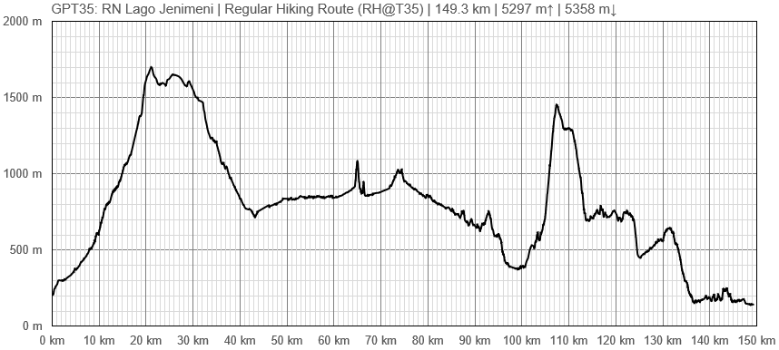
====Elevation Profile of Regular Hiking Route==== | ====Elevation Profile of Regular Hiking Route==== | ||
| − | |frame|center|Elevation Profile of Regular Hiking Route (2019)]] | + | [[File:profile GPT35.PNG|frame|center|Elevation Profile of Regular Hiking Route (2019)]] |
====Comments to Regular Hiking Route==== | ====Comments to Regular Hiking Route==== | ||
===Regular Packrafting Route=== | ===Regular Packrafting Route=== | ||
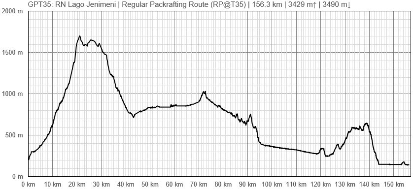
====Elevation Profile of Regular Packrafting Route==== | ====Elevation Profile of Regular Packrafting Route==== | ||
| − | [[File:|frame|center|Elevation Profile of Regular Hiking Route (2019)]] | + | [[File:profile GPT35-p.PNG|frame|center|Elevation Profile of Regular Hiking Route (2019)]] |
====Comments to Regular Packrafting Route==== | ====Comments to Regular Packrafting Route==== | ||
==Optional Routes== | ==Optional Routes== | ||
Revisión del 16:26 27 mar 2019
This article is just a draft. You can help by expanding and improving its content
|
| ||||||||||||||||||||||||||||||||||||||||||||||||||||
Section Statistics
Basic statistics
| Traversable | Nov - Apr (Conditionally: Oct, May) | |
| Packraft | Very Useful (38.8 km | 38.8 % on Water) | |
| Hiking | Packrafting | |
| Attraction | 4 / 5 | 5 / 5 |
| Difficulty | 5 / 5 | 5 / 5 |
| Distance | 149.3 km | 47 h | 156.3 km | 44 h |
| Direction | Both ↓↑ | Both ↓↑ |
| Comment | - | |
| Status | Published and Verified | |
| Zone | H: Zona Aysen Sector Sur | |
| Region | Chile & (Argentina): Aysén (XI) | |
| Start | Chile Chico, Puerto | |
| Finish | Cochrane | |
| Previous Section | Next Section | Alternative Section |
| GPT34 | GPT36H or GPT36P | No |


