Diferencia entre revisiones de «Cerro La Campana (english)»
m (Texto reemplazado: «|right|» por «|») |
m (Texto reemplazado: «|250px|» por «|») |
||
| Línea 8: | Línea 8: | ||
== The Route == | == The Route == | ||
The route from the entrance of the park is well sign-posted and very easy to follow (you also get a map). It is also surprisingly crowded for a Chilean hiking trail. The lower sections are of quite interesting forest at a reasonable gradient. The higher sections get very unpleasant towards the top with a very steep eroded path. The view from the top is worth it though as on a clear day you can see a vast section of the Central Cordillera with Aconcagua a clear high point. The only real way back is via the same way but there is also an old mining road that you can also take. | The route from the entrance of the park is well sign-posted and very easy to follow (you also get a map). It is also surprisingly crowded for a Chilean hiking trail. The lower sections are of quite interesting forest at a reasonable gradient. The higher sections get very unpleasant towards the top with a very steep eroded path. The view from the top is worth it though as on a clear day you can see a vast section of the Central Cordillera with Aconcagua a clear high point. The only real way back is via the same way but there is also an old mining road that you can also take. | ||
| − | [[Archivo:IMG_2656_(Medium).JPG|thumb | + | [[Archivo:IMG_2656_(Medium).JPG|thumb|Exspansive views over the high Andes from the summit]] |
'''Estimated time''' | '''Estimated time''' | ||
Revisión del 11:25 13 oct 2016

|
Contenido
Season
October to April
Access
Vehicle Access
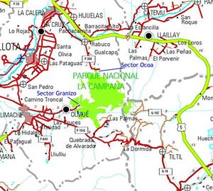
Take Ruta 5 (Route 5), to the exit to Til Til (Ruta G.132). Take this exit west, where after 9 km you will reach a steely bridge, turn right until you get to the town of Til Til (10 km from the bridge); here take the route that will take you to Limache/Olmué by taking the Cuesta de la Dormida. Go up and the descend Cuesta de la Dormida until reaching a fork to Olmue; here take Avenida Granizo on a northeast direction until you reach a dirt road where it is 2,4 km until the entrance of the park. Park your car here.
By public transport
Buses seem liable to change on a regular basis and even the most up to date guidebooks can be incorrect. At the time of writing (October 2009) Pullman bus do a regular service to Olmue from terminal Almeda with one leaving at 8:05 (6000 peso return), it takes roughly 2hrs. Get off the bus in the main square (a small grass square with a sign showing the way to the parks, but don't be tempted to walk from here it's still a long way). From here take a local Agrada bus (with plenty of character) on Av. Granizo (400 pesos) that show in the window that they are going to the park, it's only about 15-20 minutes. The bus will terminate at a turn around point. Here head further up the road and turn left up a dirt track that leads into the park.
Pullman buses return from a shop on Av. Granizo near the square. The return times are in the shop (nobody else will know them) and run until around 8:00pm. Check in at the shop on the way back to reserve a seat on the bus for the way home.
The Route
The route from the entrance of the park is well sign-posted and very easy to follow (you also get a map). It is also surprisingly crowded for a Chilean hiking trail. The lower sections are of quite interesting forest at a reasonable gradient. The higher sections get very unpleasant towards the top with a very steep eroded path. The view from the top is worth it though as on a clear day you can see a vast section of the Central Cordillera with Aconcagua a clear high point. The only real way back is via the same way but there is also an old mining road that you can also take.
Estimated time
The route is only a 14 km round trip but it packs in approximately 1400m of accent. It should take a fit, healthy person about 3-4 hours with roughly the same time to get down given its steepness.
Permits and Fees
It costs 1500 CLP to enter the park
Recommendations
Given the crowds and the steep and unpleasant nature of the climb in the higher reaches I’d recommend trying one of the routes in the more biologically interesting north of the park (however this area is very difficult to get to without a car). On a clear day the views from the top are spectacular though.
Trekking poles are very useful for balance on the steep areas of ascent and decent plus they will save your leg muscles.
External Links
Weather:
- Meteochile Región de Valparaíso
- Accuweather Valparaíso
- Accuweather Viña del Mar
- Meteochile Región Metropolitana
- Accuweather Santiago
- Accuweather Puente Alto
Lodging:
Revisa la lista completa de 621 rutas de trekking y las 345 rutas de montaña en Chile
|


