Diferencia entre revisiones de «GPT01 - Cerro Purgatorio»
De Wikiexplora
(→Elevation Profile) |
(→Section in Numbers) |
||
| Línea 24: | Línea 24: | ||
}} | }} | ||
{{Draft}} | {{Draft}} | ||
| − | ==Section | + | ==Section Statistics== |
{| border="1" style="border-collapse:collapse" | {| border="1" style="border-collapse:collapse" | ||
|+'''GPT01: Cerro Purgatorio''' | |+'''GPT01: Cerro Purgatorio''' | ||
Revisión del 16:02 23 mar 2019
This article is just a draft. You can help by expanding and improving its content
Section Statistics
| Traversable | Dec - Mar (Conditionally: Nov, Apr) | |
| Packraft | Only Burden | |
| Hiking | Packrafting | |
| Attraction | 1 / 5 | No Rating |
| Difficulty | 43587 | No Rating |
| Distance | 39.4 km | 14 h | 39.4 km | 14 h |
| Direction | Both ↓↑ | Both ↓↑ |
| Comment | - | |
| Status | Published and Verified, To be Recorded by GPS | |
| Zone | A: Zona Precordillera | |
| Region | Chile: Region Metropolitano (V) | |
| Start | Santiago, Metro Puente Alto | |
| Finish | El Melocotón | |
| Previous Section | Next Section | Alternative Section |
| Start | GPT02 | No |
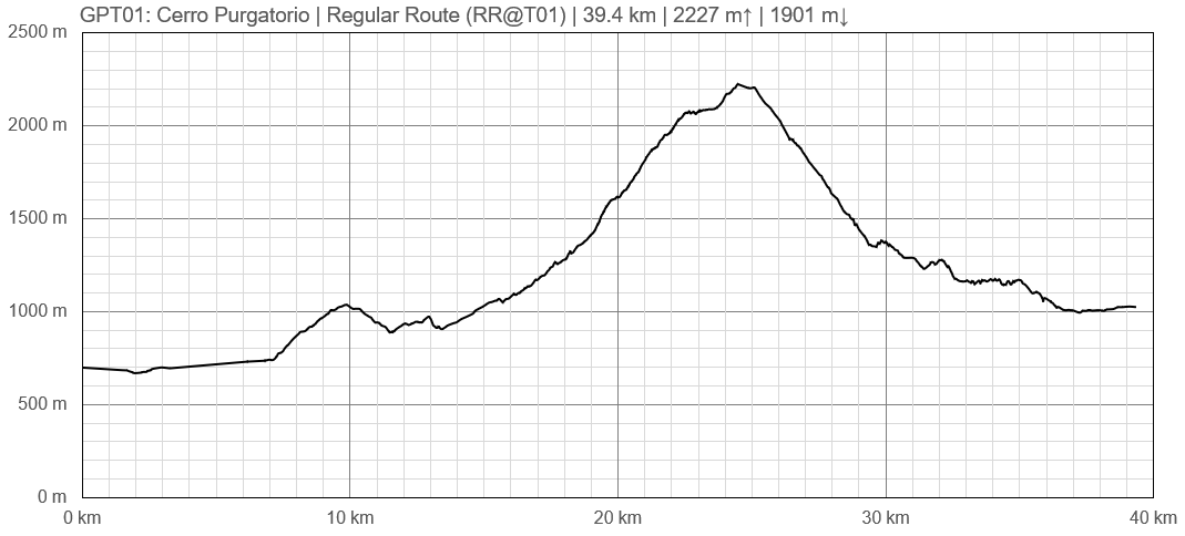
Elevation Profile


