Diferencia entre revisiones de «Estero el Peñón (english)»
m (Texto reemplazado: «Image:» por «File:») |
|||
| (No se muestran 7 ediciones intermedias de 2 usuarios) | |||
| Línea 1: | Línea 1: | ||
| − | |||
| − | |||
{{Google Translator|Estero el Peñón}} | {{Google Translator|Estero el Peñón}} | ||
| + | {| align="left" | ||
| + | |style="width:1000px"| __TOC__ | ||
| + | |<googlemap version="0.9" lat="-32.855852" lon="-70.21427" zoom="14" width="380" height="390" type="satellite"> | ||
| + | http://www.wikiexplora.com/kml/Estero_el_Penon.kml</googlemap> | ||
| + | |style="width:1000px" valign="top" |{{Trekking Chile}} | ||
| + | {{Rando Chile}} | ||
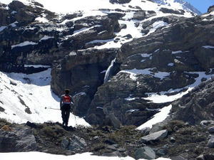
| + | [[File:Estero el penon.jpg|thumb|Estero El Penon. Arriving at the waterfall. Looking northeast, October 2009]] | ||
| + | |} | ||
| − | [[ | + | {{linea divisoria invisible}} |
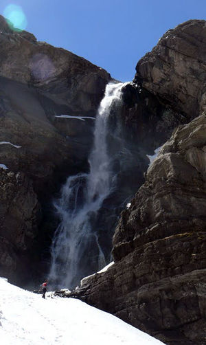
| + | [[File: Estero_el_penon_.jpg|thumb|Cascada del Estero The Rock]] | ||
== Season== | == Season== | ||
The right time for this route is from September to May. There will be enough snow from June to August | The right time for this route is from September to May. There will be enough snow from June to August | ||
== Access == | == Access == | ||
| − | From Los Andes, take the international route to Mendoza CH-60. We must continue along this road for approximately pass the Old Guard and control, 6.3 miles later, turn left onto a dirt road vehicle on [[State Road | | + | From Los Andes, take the international route to Mendoza CH-60. We must continue along this road for approximately pass the Old Guard and control, 6.3 miles later, turn left onto a dirt road vehicle on [[State Road |regular condition]] that the internal Quebrada del Estero the Rock. They are 2.8 kilometers of road vehicle, built for the construction of the hydroelectric plant. However, it is recommended to park about 100 meters before the end to avoid crossing a ditch that crosses the road. |
=== Public transport and hitchhiking === | === Public transport and hitchhiking === | ||
| Línea 14: | Línea 21: | ||
==Route description== | ==Route description== | ||
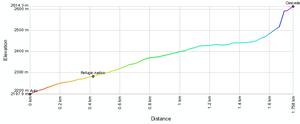
| − | [[ | + | [[File: Perfil_Estero_el_penon.png|thumb|Profile of the short route del Estero The Rock]] |
| + | |||
| − | |||
The route begins in the conducting channel of the hydroelectric plant. From this point you should start walking toward the north. It is quite evident, because the waterfall is visible from the car itself. You must walk about 100 meters along the canal to the stream itself. At this point, begin to ascend the west bank of the creek, climbing a slope initially somewhat rough. Then he continued making progress for about 10 minutes by a relatively clear path to cross a small stream secondary. Just after this, there is a haven of carriers at the foot of a large Rocon. Then he should follow up the valley for about half an hour, in between bushes and rocks scattered to the foot of the waterfall. There's nothing like getting lost on a route so short and so encased. The waterfall is about 20 meters, and discharge from the melting glacier of Cerro Gloria, whose ascent route this short trek is only the beginning. | The route begins in the conducting channel of the hydroelectric plant. From this point you should start walking toward the north. It is quite evident, because the waterfall is visible from the car itself. You must walk about 100 meters along the canal to the stream itself. At this point, begin to ascend the west bank of the creek, climbing a slope initially somewhat rough. Then he continued making progress for about 10 minutes by a relatively clear path to cross a small stream secondary. Just after this, there is a haven of carriers at the foot of a large Rocon. Then he should follow up the valley for about half an hour, in between bushes and rocks scattered to the foot of the waterfall. There's nothing like getting lost on a route so short and so encased. The waterfall is about 20 meters, and discharge from the melting glacier of Cerro Gloria, whose ascent route this short trek is only the beginning. | ||
| − | + | ===Expected Time === | |
| − | At a normal pace, this trek should take about 40-50 minutes until the fall, and about 25 minutes to return. In view of brevity, only recommended as complementary to those who are walking in the area, but does not justify a special trip from Santiago or from the central coast. It is, for example, a good addition if you go to [[Glaciar del Juncal]] or [[Laguna del Inca]]. | + | At a normal pace, this trek should take about 40-50 minutes until the fall, and about 25 minutes to return. In view of brevity, only recommended as complementary to those who are walking in the area, but does not justify a special trip from Santiago or from the central coast. It is, for example, a good addition if you go to [[Glaciar del Juncal]] or [[Laguna del Inca]]. |
== Permits / Fees == | == Permits / Fees == | ||
| Línea 26: | Línea 33: | ||
==Waypoints in Google Earth== | ==Waypoints in Google Earth== | ||
* [[Media: Estero_el_penon.kmz | Route Estero The Rock]]. <br> {{Download waypoints}} | * [[Media: Estero_el_penon.kmz | Route Estero The Rock]]. <br> {{Download waypoints}} | ||
| − | |||
| − | |||
| − | |||
| − | |||
| − | |||
| − | |||
| − | |||
| − | |||
| − | |||
| − | |||
| − | |||
| − | |||
| − | |||
Revisión actual del 10:23 18 oct 2016
| <googlemap version="0.9" lat="-32.855852" lon="-70.21427" zoom="14" width="380" height="390" type="satellite">
http://www.wikiexplora.com/kml/Estero_el_Penon.kml</googlemap> |
|
Season
The right time for this route is from September to May. There will be enough snow from June to August
Access
From Los Andes, take the international route to Mendoza CH-60. We must continue along this road for approximately pass the Old Guard and control, 6.3 miles later, turn left onto a dirt road vehicle on regular condition that the internal Quebrada del Estero the Rock. They are 2.8 kilometers of road vehicle, built for the construction of the hydroelectric plant. However, it is recommended to park about 100 meters before the end to avoid crossing a ditch that crosses the road.
Public transport and hitchhiking
You can easily reach this point in one of the numerous buses that run from Santiago to Mendoza. Among other, you can take Ahumada, El Rapido, Cata, Tac, Tur Bus and Andesmar. Most of them depart from Los Héros bus station. They charge about CLP $12.000 per person to Mendoza.
Route description
The route begins in the conducting channel of the hydroelectric plant. From this point you should start walking toward the north. It is quite evident, because the waterfall is visible from the car itself. You must walk about 100 meters along the canal to the stream itself. At this point, begin to ascend the west bank of the creek, climbing a slope initially somewhat rough. Then he continued making progress for about 10 minutes by a relatively clear path to cross a small stream secondary. Just after this, there is a haven of carriers at the foot of a large Rocon. Then he should follow up the valley for about half an hour, in between bushes and rocks scattered to the foot of the waterfall. There's nothing like getting lost on a route so short and so encased. The waterfall is about 20 meters, and discharge from the melting glacier of Cerro Gloria, whose ascent route this short trek is only the beginning.
Expected Time
At a normal pace, this trek should take about 40-50 minutes until the fall, and about 25 minutes to return. In view of brevity, only recommended as complementary to those who are walking in the area, but does not justify a special trip from Santiago or from the central coast. It is, for example, a good addition if you go to Glaciar del Juncal or Laguna del Inca.
Permits / Fees
- This route does not require permits or admission is charged
Waypoints in Google Earth
- Route Estero The Rock.
To download the file right-click and then select "Save file as" (IE) or "Save link as" (Firefox, Chrome). By trying to open it directly, some browsers will show the raw code with the coordinates.


