Diferencia entre revisiones de «Plantilla:Access to Caleu»
m (Texto reemplazado: «|200px|» por «|») |
(→Acceso) |
||
| (No se muestra una edición intermedia de otro usuario) | |||
| Línea 1: | Línea 1: | ||
| − | == | + | == Access == |
| − | === | + | === By car === |
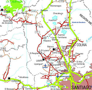
| − | [[ | + | [[Image:Mapa_acceso_el_Roble.jpg | thumb | Map of access to the Oak. The starting point is marked with a star. Image: [http://www.vialidad.cl Dirección de Vialidad]]] |
| − | + | From [[Santiago]], you must take the Pan-American highway (route 5) in the north direction. The detour to Rungue is at kilometer 54. You must take that exit and enter the town. Where the street ends, we must turn left and, a few meters further on, turn right (the street ends anyway) to cross an estuary. Immediately after crossing the estuary, you should turn left, and begin to skirt the estuary along a gravel road in [[state of the road | good condition]]. The Rungue reservoir will then be bordered. After 3.9 kilometers from the Pan-American highway, there is a detour to the right ("A Caleu") which must be taken. This road, also gravel in [[state of the road | good condition]], goes through the valley and ascends progressively. Approximately on the 11th kilometer from the turnoff (14.9 from the Pan-American Highway) Caleu has been reached and a fork arises: you must take the left, which continues up the hill. 970 meters above, just before the passage to the valley of Olmué, the path to the oak tree appears on the right. | |
| − | === | + | === In public transport and hitchhiking === |
| − | + | From the La Paz bus terminal, located on Avenida La Paz and Dávila Baeza street, daily buses depart for Til Til, from 6 AM and every 15 minutes. At 16.00, a bus leaves for Caleu. Passage value $ 1,600. | |
| − | + | It is quite a busy road, so the possibilities of hitchhiking are rather high. | |
Revisión actual del 20:13 6 jun 2019
Access
By car

From Santiago, you must take the Pan-American highway (route 5) in the north direction. The detour to Rungue is at kilometer 54. You must take that exit and enter the town. Where the street ends, we must turn left and, a few meters further on, turn right (the street ends anyway) to cross an estuary. Immediately after crossing the estuary, you should turn left, and begin to skirt the estuary along a gravel road in good condition. The Rungue reservoir will then be bordered. After 3.9 kilometers from the Pan-American highway, there is a detour to the right ("A Caleu") which must be taken. This road, also gravel in good condition, goes through the valley and ascends progressively. Approximately on the 11th kilometer from the turnoff (14.9 from the Pan-American Highway) Caleu has been reached and a fork arises: you must take the left, which continues up the hill. 970 meters above, just before the passage to the valley of Olmué, the path to the oak tree appears on the right.
In public transport and hitchhiking
From the La Paz bus terminal, located on Avenida La Paz and Dávila Baeza street, daily buses depart for Til Til, from 6 AM and every 15 minutes. At 16.00, a bus leaves for Caleu. Passage value $ 1,600. It is quite a busy road, so the possibilities of hitchhiking are rather high.
