Diferencia entre revisiones de «GPT01 - Cerro Purgatorio»
De Wikiexplora
(Página creada con «{{RutaForm2 |Actividad=Trekking |País=Chile |CiudadesChile=Santiago |VallesStgo=Valle Maipo |BellezaEscenica=Discreta |Atractivos=Vistas panorámicas |Duracion=2 días |Re...») |
|||
| Línea 1: | Línea 1: | ||
| − | {{ | + | {{RutaForme |
|Actividad=Trekking | |Actividad=Trekking | ||
|País=Chile | |País=Chile | ||
| Línea 16: | Línea 16: | ||
|MetrosDescenso=1901 | |MetrosDescenso=1901 | ||
|Primer Autor=[[user:Jandudeck|Jan Dudeck]] | |Primer Autor=[[user:Jandudeck|Jan Dudeck]] | ||
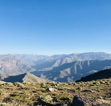
| − | |Imágen Principal= | + | |Imágen Principal=gpt01 Cerro Purgatorio.jpg |
| − | |ComentariosImagen= | + | |ComentariosImagen=View to the central Andes, by [http://notabadplacetopee.com/gpt01/ Austin Davis] |
|KMLZ=GPT01 - Cerro Purgatorio.kmz | |KMLZ=GPT01 - Cerro Purgatorio.kmz | ||
|TipoDeMap=HYBRID | |TipoDeMap=HYBRID | ||
| Línea 76: | Línea 76: | ||
|Start | |Start | ||
|GPT02 | |GPT02 | ||
| − | No | + | |No |
|} | |} | ||
==Section Planning Status== | ==Section Planning Status== | ||
Revisión del 18:34 19 mar 2019
This article is just a draft. You can help by expanding and improving its content
Basic statistics
| Traversable | Dec - Mar (Conditionally: Nov, Apr) | |
| Packraft | Only Burden | |
| Hiking | Packrafting | |
| Attraction | 1 / 5 | No Rating |
| Difficulty | 43587 | No Rating |
| Distance | 39.4 km | 14 h | 39.4 km | 14 h |
| Direction | Both ↓↑ | Both ↓↑ |
| Comment | - | |
| Status | Published and Verified, To be Recorded by GPS | |
| Zone | A: Zona Precordillera | |
| Region | Chile: Region Metropolitano (V) | |
| Start | Santiago, Metro Puente Alto | |
| Finish | El Melocotón | |
| Previous Section | Next Section | Alternative Section |
| Start | GPT02 | No |


