Diferencia entre revisiones de «Glaciar Alto del Plomo»
(→Waypoints - Google Earth) |
|||
| Línea 87: | Línea 87: | ||
*[[Media:Puntos_Trek_Fco_Moreno.gdb|Waypoints Map Source]]. | *[[Media:Puntos_Trek_Fco_Moreno.gdb|Waypoints Map Source]]. | ||
{{Descargar waypoints}} | {{Descargar waypoints}} | ||
| + | <br><br><br> | ||
| + | {{Start english text|{{Download waypoints}} }} | ||
[[category:Trekking en Chile]] | [[category:Trekking en Chile]] | ||
Revisión del 13:45 31 oct 2009

|
Epoca adecuada / Season
La época adecuada para el trekking es entre los meses de Noviembre y Abril.
The season for this trek is between the months of November and April.
Acceso en auto y estado del camino / Vehicle Access and State of the Road
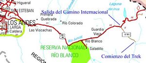
Desde Los Andes, se debe tomar la ruta internacional a Mendoza CH-60. Se debe continuar por este camino por aproximadamente 50 km. y salirse a la izquierda inmediatamente antes de la cuesta de 20 curvas que termina en Portillo, acá nace un camino de tierra que se interna por el mismo valle que recorría el ferrocarril a Mendoza, aún se distinguen vestigios de sus lineas e instalaciones. Este camino por lo general se encuentra en buen estado (dependerá de la última vez que pasó vialidad). Luego de aproximadamente 8 kilometros se llegará a dos casas, residencia de verano del arriero del valle. Este es el punto de inicio del sendero.
From Los Andes, you should take the international road to Mendoza CH-60. Continue on this road for approximately 50 km and exit immediately before the 20-curve slope that ends in Portillo, here begins a dirt road that penetrates the same valley that the railroad used to travel to Mendoza, you can still find traces of its tracks and installations. This road, is generally in good shape. After approximately 8 km you will see two houses, a summer residence for the valley muleteer. This is where the trek begins.
Acceso en transporte público y autostop / Public Transportation and Hitchhiking
Descripción de la ruta / Route description
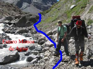
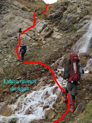
Este trek comparte la primera parte de la ruta con el trek Glaciar del Juncal, seguir éste hasta cruzar el estero Monos de Agua. Una vez en la ribera sur hay que seguir su curso aguas arriba internandonos al este. Dependiendo de la hora de partida el sector previo al cruce del rio puede ser un muy buen lugar para acampar, de esta manera uno se asegura hacer el cruce a primera hora de la mañana con un menor caudal. A partir de este punto la huella es difusa y hay que tener algo de habilidades buscando huellas; como regla general ir siempre por la orilla sur del rio. Luego de 45 minutos del cruce de éste la ladera de los cerros y el rio prácticamente se juntan dejando poco espacio para el sendero, en partes habrá que usar las rocas del rio para abrirse paso. Este estrechamiento no dura más de un kilómetro. Una vez que el rio vuelve a alejarse de la ladera y hay que continuar por 2,5 horas (3 kilometros aproximadamente) hasta que un acarreo da fin al valle. Subir parte de este acarreo en el que se distiguen algunas huellas y cruzar al norte el rio que a esta altura ya no es más que un riachuelo, una vez que se ha cruzado se sube por una garganta en dirección este por alrededor de 1,5 hrs donde se llega al valle del glaciar Alto del Plomo. Este es un buen lugar para instalar el segundo y último campamento, la próxima jornada será por el día.
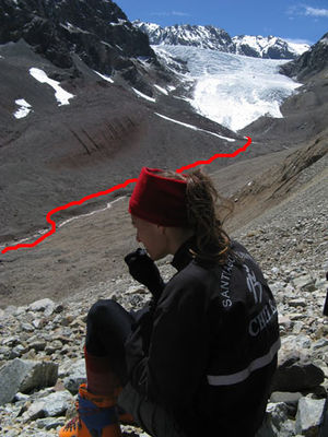
Desde este punto ya no se distingue la ruta sin embargo la dirección es clara ya que es posible ver el glaciar a 3 km de distancia. Es aconsejable fijarse bien en el lugar del campamento y tomar referencias para no perder el campamento a la vuelta. Desde la carpa internarse por el valle, despues de 30 minutos aprox. se llega al rio de éste, cruzar a su ribera norte y seguir su curso por unas 1,5 horas hasta llegar al punto en que es más conveniente enfilar en linea recta al glaciar que seguir la gran vuelta que da el rio para llegar a los hielos. Luego de una hora se llega al glaciar Alto del Plomo.
Tanto para volver a la carpa como para volver al estacionamiento rehacer la misma ruta hecha a la ida, en el primer caso tomará 3 horas y en el segundo una jornada completa.
This trek shares the first stretch of the route with the trek Glaciar del Juncal, follow it until crossing the river Monos de Agua. Once at the south river bank, you must follow the course of its waters towards the east. Depending on the start time, the area right before the crossing of the river can be a very good camping place, this way you will be sure to cross the river first time in the morning, when the river should be carrying less volumes of water. Starting here, the path gets somewhat lost. As a general rule, always keep on the south river bank. After about 45 minutes of crossing it, the hillside and the river practically get together leaving a very small space for the path, at times you will have to use the river rocks to make your way. This narrowing of the path does not last for more than 1 km. Once the river gets farther from the hillside again the trek continues for about 2,5 hours (approximately 3 km) until a slope gives an end to the valley. Ascend part of this slope and cross to the north of the river, once you have crossed you go up a narrow pass towards the east for approximately 1,5 hrs where you will reach the valley of the Alto del Plomo glacier. Here is a good place for your second camp. From this point on you will no longer be able to distinguish the path, but the direction is clear since it is possible to see the glacier at a distance of 3 km. It is recommended to look well at you camping place and check for references so that you don't get lost on your way back from the glacier. From the tent penetrate the valley, after approximately 30 minutes you will reach the glacier's river, cross its north bank and follow its course for about 1,5 hours until reaching a spot where it is more convenient to get to its ice on a straight line rather than going around. After about an hour you will reach the Alto del Plomo Glacier. Take the same route back to the campsite and parking lot. It takes about 3 hours to the former, and an entire day to the later.
Tiempo esperado / Estimated Time
Trek de 4 días considerando un primer día tranquilo de 3 horas de marcha, sin embargo es posible de ser efectuado en 3 días considerando un comienzo temprano el primer día. En este último caso el primer y único campamento debiera de fijarse antes del acarreo del final del valle del Monos de Agua.
4 day Trek considering a first easy day of a walking for 3 hours. It is possible to do it in 3 days starting early on the first day. In this case the first and only camp site would be at the before the slope at the end of the Monos de Agua Valley.
Permisos - Tarifas / Permits - Fees
El fundo es propiedad privada, sin embargo rara vez se controla el acceso. Aparentemente se quiere crear un parque y se está fomentando la ida de excursionistas. Pedir permiso a:
This is private property, but the access is rarely controlled. For permission speak to:
CATHERINE KENRICK ckenrick@terra.cl 09 3376336 02- 2288534
Comunidad Kenrick Lyon propietarios Parque Andino Juncal
Recomendaciones / Recommendations
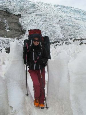
Es posible montarse sobre el glaciar Alto del Plomo para tener una visión global de este enorme glaciar o pequeño campo de hielo, que también se descuelga hacia Argentina al río Plomo. Una vez en lo alto del glaciar, con equipamiento de montaña (arnés, cuerda, piolet, crampones) y conocimiento de montaña, es posible transitar sobre el glaciar rumbo al norte y subir alguna de las variadas y bellas montañas presentes como León Negro, León Blanco, Alto del Río Blanco, Central, entre otros. Considerar dos días adicionales si se desea subir alguna de estas montañas.
El nombre "Alto del Plomo" viene ya que existe otro glaciar más abajo en el río Plomo (glaciar Bajo del Plomo) dentro de Argentina. "Francisco Moreno" es el nombre del paso existente al montarse sobre el glaciar Alto del Plomo desde Chile, y que comunica hacia el valle del río Plomo en Argentina.
It is possible to mount Alto del Plomo Glacier to get a global vision of this gigantic glacier or small ice field, that also hangs to Argentina to the river Plomo. Once high at the glacier, with mountain equipment (harness, rope, ice axe, crampons) and mountain knowledge, it is possible to transit on the glacier with direction north and ascend one of these beautiful mountains like Leon Negro, Leon Blanco, Alto del Rio Blanco, Central, among others. Consider two additional days to ascend one of these mountains.
Waypoints - Google Earth
Para descargar el archivo se recomienda hacer click con el botón derecho del mouse y luego seleccionar "Guardar destino como" (Internet Explorer), "Guardar enlace como" (Firefox) o "Save link as" (Google Chrome). Si se intenta abrir directamente, algunos navegadores abrirán el código crudo del archivo con el listado de coordenadas.
To download the file right-click and then select "Save file as" (IE) or "Save link as" (Firefox, Chrome). By trying to open it directly, some browsers will show the raw code with the coordinates.

