Diferencia entre revisiones de «Estero Aucayes (english)»
m (Texto reemplazado: «|200px|» por «|») |
m (Texto reemplazado: «|right|» por «|») |
||
| Línea 6: | Línea 6: | ||
== Access == | == Access == | ||
===By car === | ===By car === | ||
| − | [[Image: mapa_acceso_maitenes.jpg|thumb | + | [[Image: mapa_acceso_maitenes.jpg|thumb|Map to Maitenes]] |
The Trekking Aucay Estero, must be one of the most beautiful and near the capital of those are available: From Santiago to take road to Cajon del Maipo. There are 22 km paved road to the turnoff to El Alfalfal, where you should turn left. Since there are 14 miles of paved road also very good quality to the town of Maitenes begins the tour. | The Trekking Aucay Estero, must be one of the most beautiful and near the capital of those are available: From Santiago to take road to Cajon del Maipo. There are 22 km paved road to the turnoff to El Alfalfal, where you should turn left. Since there are 14 miles of paved road also very good quality to the town of Maitenes begins the tour. | ||
| Línea 19: | Línea 19: | ||
==Route description == | ==Route description == | ||
| − | [[Image: DSCN1824.jpg|thumb | + | [[Image: DSCN1824.jpg|thumb|the end of the road along the irrigation canal is this nice suspension bridge that allows us to pass on the south side of the box]] |
[[Image:Mapa estero aucayes.jpg|thumb|left|trekking map of the estuary Aucay]] | [[Image:Mapa estero aucayes.jpg|thumb|left|trekking map of the estuary Aucay]] | ||
The best reference to find the driveway, is a railway line used to get a cart with people from the premises of the Intake few tens of meters above the rail line this soon after the bridge that has the sign of "Estero Aucay, the right side of the road (south) is very visible, there is no way of getting lost. Few meters to the left of this train line, it terminates the trellis, and the trail begins just behind a road signage. This trail climbs in less than 10 minutes to a beautiful house belonging to machines of the Intake facility is right next to this house of machines that will find the trail again, again in a few minutes brings us to the top of the hill, which housed an artificial lagoon. This lake is skirted by the left when it is facing south (east side of the lagoon) and from there follow the wide path that is parallel to an irrigation canal, this area is very beautiful product of the vegetation. Approximately 30 minutes running lead to a suspension bridge, which must cross to move to the south side of the Cajon Aucay, already visible in much of its length. Across the bridge there you take a path that descends to the facilities and re-cross the north side, follow the path up and then head directly to the east, passing by the latest facilities Intake, a red shack and a few rustic tables and chairs typical constructions of carriers. | The best reference to find the driveway, is a railway line used to get a cart with people from the premises of the Intake few tens of meters above the rail line this soon after the bridge that has the sign of "Estero Aucay, the right side of the road (south) is very visible, there is no way of getting lost. Few meters to the left of this train line, it terminates the trellis, and the trail begins just behind a road signage. This trail climbs in less than 10 minutes to a beautiful house belonging to machines of the Intake facility is right next to this house of machines that will find the trail again, again in a few minutes brings us to the top of the hill, which housed an artificial lagoon. This lake is skirted by the left when it is facing south (east side of the lagoon) and from there follow the wide path that is parallel to an irrigation canal, this area is very beautiful product of the vegetation. Approximately 30 minutes running lead to a suspension bridge, which must cross to move to the south side of the Cajon Aucay, already visible in much of its length. Across the bridge there you take a path that descends to the facilities and re-cross the north side, follow the path up and then head directly to the east, passing by the latest facilities Intake, a red shack and a few rustic tables and chairs typical constructions of carriers. | ||
| − | [[Image: Perfil_estero_aucayes.png|thumb | + | [[Image: Perfil_estero_aucayes.png|thumb|Profile approximate route. The section plane corresponds to the channel]] |
The path is clear at first, moving among dense vegetation and after about 1 hour for the first time low to the estuary itself, following the edge of the water turns to find the trail that gains altitude quickly while continuing to go down the drawer. After about 6 or 8 hours of walking you can reach the bottom of the drawer, closed by a circle of cliffs by which some paths cross at the top. | The path is clear at first, moving among dense vegetation and after about 1 hour for the first time low to the estuary itself, following the edge of the water turns to find the trail that gains altitude quickly while continuing to go down the drawer. After about 6 or 8 hours of walking you can reach the bottom of the drawer, closed by a circle of cliffs by which some paths cross at the top. | ||
Revisión del 20:43 10 oct 2016

|
Contenido
Season
This trek can be practiced throughout the year, trasita at low altitude so the snow does not cut or gets access to fall into the low pate del Estero. Is more beautiful in spring by the flowering of the vegetation.
Access
By car
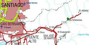
The Trekking Aucay Estero, must be one of the most beautiful and near the capital of those are available: From Santiago to take road to Cajon del Maipo. There are 22 km paved road to the turnoff to El Alfalfal, where you should turn left. Since there are 14 miles of paved road also very good quality to the town of Maitenes begins the tour.
Public transport and hitchhiking
The municipal bus line (Turmaipo) conducts tours to Baños Morales. From October until 1 January, the bus departs on Saturdays, Sundays and holidays. A count of the first of January until 15 March, a bus leaves every day. The exit is on the Metrobus Terminal Bellavista de la Florida (penultimate station on subway line 5). If you have questions subway guards can help. The return value of the passage to Banos Morales is $ 6,000 (the amount in Turmaipo confirm: 8611518 to 8612450, or their website). There are rates for intermediate lengths. The output bus from the terminal is performed at 8:30 and get a bus a day. You can also take this bus in Puente Alto, outside the station Las Mercedes, where the bus passes close at 8:50. You'll recognize the bus by its number, "MB-72". You should stop at the turnoff to Alfalfal
There is no public transportation to Maitenes can hitchhike from the turnoff to the Alfalfal. It is convenient to go by car itself, the road is of very good quality and we do not require a 4x4 vehicle.
It is also possible to privately hire the minibus Turismontaña (850 05 55 / 850 07 83) and fix a price to the same starting point.
Route description
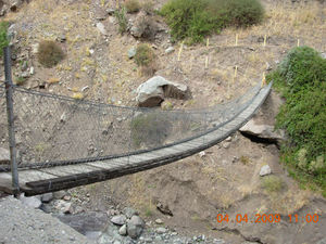
The best reference to find the driveway, is a railway line used to get a cart with people from the premises of the Intake few tens of meters above the rail line this soon after the bridge that has the sign of "Estero Aucay, the right side of the road (south) is very visible, there is no way of getting lost. Few meters to the left of this train line, it terminates the trellis, and the trail begins just behind a road signage. This trail climbs in less than 10 minutes to a beautiful house belonging to machines of the Intake facility is right next to this house of machines that will find the trail again, again in a few minutes brings us to the top of the hill, which housed an artificial lagoon. This lake is skirted by the left when it is facing south (east side of the lagoon) and from there follow the wide path that is parallel to an irrigation canal, this area is very beautiful product of the vegetation. Approximately 30 minutes running lead to a suspension bridge, which must cross to move to the south side of the Cajon Aucay, already visible in much of its length. Across the bridge there you take a path that descends to the facilities and re-cross the north side, follow the path up and then head directly to the east, passing by the latest facilities Intake, a red shack and a few rustic tables and chairs typical constructions of carriers.
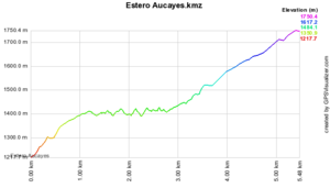
The path is clear at first, moving among dense vegetation and after about 1 hour for the first time low to the estuary itself, following the edge of the water turns to find the trail that gains altitude quickly while continuing to go down the drawer. After about 6 or 8 hours of walking you can reach the bottom of the drawer, closed by a circle of cliffs by which some paths cross at the top.
Expected Time
If the idea is to go trekking, you can go by the day, advancing 1 / 3 of the Cajon, enjoy the water and landscape and back. Two days can easily arrive to the bottom of the drawer and enjoy the water and landscapes.
For mountain activities are recommended in three days thereafter, depending on the objectives. On the barrier cliffs that closes the estuary, is a circus compound from north to south by the High for the Broncos, Alto de las Amarillas, Punta del Paraiso and Echaurren. Splendid mountains of varying degrees of difficulty scarcely promoted in part, along the approach that allows in general, try a normal weekend.
Permits / Fees
So far, no permits are required. However, access to this valley will surely be affected by the Maipo Alto project that involves work in the sector and perhaps implying further restrictions.
Recommendations
Waypoints in Google Earth
- Ruta del estero Aucay. The section of the route after the bridge is for reference only. To download the file right-click and then select "Save file as" (IE) or "Save link as" (Firefox, Chrome). By trying to open it directly, some browsers will show the raw code with the coordinates.


