![]()
ENG:Valle Avilés

| |


|
|
|
| |||||||||||||||||||||||||||||||||||||||||||||||||


General Description


A wonderful trek through the valley of the Aviles River which connects Jeinemeni National Reserve with Estancia Chacabuco, a national park in the making. The trail follows a route the first colonists in the area used to travel between Cochrane and Chile Chico. While this description is from north to south, it is also possible to do this route in reverse.
Access
In Private Vehicle
Jeinemeni National Reserve is located 65 km south of Chile Chico by a gravel road in bad conditions. All wheel drive is highly recommended. Please take into consideration that this trek does not end where it starts, so going in a private car is not a very good idea.
The trek ends at Stone House Campground in Estancia Chacabuco. The campground is next to the highway to Argentina through Roballes Pass, which is another gravel road but is maintained in good condition.
Public transport and hitchhiking
There is no public transport to Jeinemeni National Reserve, and there are few cars to make hitching feasible. The best way to hire a tour in Chile Chico, which in summer 2014 cost 60.000 CLP for a group of up to 4 people, and arrange to have the tour company drop you off at the administration where the trek begins. This way you can also do the trekking to the Cueva de las Manos and see other attractions in the area.
There is no public transportation from Stone House Campground. However, with a bit of patience, hitching is possible.
Route description

Day One
- Administration - Refugio Valle Hermoso
- Duration: 6-7 hours
- Physical difficulty: Medium
- Technical difficulty: Low
The route begins in the administration of the Reserve. Here CONAF has a campground next to Jeinimeni Lake (10,000 CLP as of summer 2014). It's not a bad idea to talk with the rangers about the status of the trail, especially for the level of water in the many rivers and streams higher up in the valley.
From the entrance, follow the 4x4 track to the edge of Lake Jeinimeni. The trails rounds the lake on its southern side, on sunny days granting stunning views of the arid mountains reflected in the still waters. The trail is flat and makes for a pleasant walk. There are some river crossings, which, later in the day or if it has rained recently, will mean having to take off your shoes and getting your feet wet. After one or one and half hours you'll see a shallow lagoon on your left. Cross the small drainage stream and continue west into the interior. Half an hour after the lagoon you reach a deep river with a strong current, take care in its crossing.
After the river the 4x4 track is practically non existent. Follow the cairns, small piles of stones, in order to traverse a rocky wash to the entrance of a small forest.
The trail quickly leaves the forest and there is a fork, clearly marked by a sign. One trail goes to Lago Verde and the other to Valle Hermoso. Take the trail to Valle Hermoso, to the northwest. This trail enters into a dense forest and then exits into yet another river valley. From here we have our first view of the snow and glaciers of the Cordon de la Gloria. Follow the cairns northwest up the valley. Here you'll have to cross many small streams, but none should present any real problem. All the while pay attention to your left hand side for the entrance to the forest and the start of the climb to the pass. The pass itself is an obvious opening in the mountains, and is well marked with a pile of rocks and ribbons tied to the trees. We started the climb 4 hours after the administration.
The climb is short but intense, 400 meters in about 30 or 45 minutes. From the top, we have our first view of the spectacular Lago Verde. This glacial lake is surrounded on all sides by fjord like cliffs, and its turquoise water glisten in the afternoon sun. The descent is as abrupt as the ascent, but the incredible views towards the glaciers of Valle Hermoso and the lake below you are ample reward. Half an hour or 45 minutes on a small beach is reached.
Here a little bit of route finding maybe required. Cross the river and continue alongside the lake. 50 or 100 meters on you have to cross another, deeper river. Look for a spot where the river divides into many shallow streams. The trail leading up valley is well marked with two parallel lines of stones, but on the rocky beach it can be easy to miss.
The trail leaves the lake behind, sometimes passing though the forest and other times on the rocky wash left by the many rivers in the area. 45 minutes from the lake shore you arrive in the Refugio Valle Hermoso, 6 hours from the Administration. The refugio offers benches, a fire pit, and shelter from the elements and is a great place to pitch your tent. One could easily spend a day exploring the aptly named Valle Hermoso. Many glaciers are at half day's walk and the tranquility is unforgettable.
Day Two
- Refugio Valle Hermoso to Puesto Limite
- Duration: 4 or 5 hours
- Physical difficulty: Low
- Technical difficulty: Medium
In this stretch you will have to cross many small streams. It is very important to have a pair of sneakers or sports sandals that can get wet or you will waste time taking off and putting on your hiking boots. This author recommends a good pair of Crocs. As a general rule, always look for where rivers divide into many shallow streams to find a safe place to cross. Follow the cairns and red poles towards the end of the valley. The path is always clear, but depending on the water level, it's possible you will have to leave the path in search of a safe crossing.
From afar we can start to make out the entrance to the Aviles Valley, since it is the only opening between the mountains that heads southward (to the left). The trail enters the forest 2 or 3 hours from the refugio. The entrance is very well marked with stones and ribbons tied to trees. The beautiful lenga forest is dense, and can make route finding difficult, but at least there are no more streams.
The climb to the pass is very gradual and you'll reach the top an hour after entering the forest. Here you have a beautiful view of the Aviles river to the south and the glaciers of Valle Hermoso behind you. You are now entering the private property of Estancia Chacabuco. The descent to Puesto Limite, a campground at the end of the Estancia's property, is very fast. Here you'll find a palisade to protect your tent from the wind, a fire pit, and benches.
According to the map, Google Earth, and the view from the pass, it should be possible to arrive to another glacier and lake from Puesto Limite. This author could not find the trail however. It's possible Conservacion Patagonica will build a trail in the future.
Day Three
- Puesto Limite - Stone House Campground
- Duration: 7 or 8 hours
- Physical difficulty: Low
- Technical difficulty: Low
Now in the property of the Estancia, the trail is very well marked. There are many sites apt for camping which can facilitate two shorter days if your party is tired. Follow the trail to the south. 45 minutes or an hour after Puesto Limite you'll reach another campsite. Take water from the river itself. A few minutes on the trail fords the Aviles River. The trail enters the forest again and starts a long, gradual descent. Two kilometers after crossing the Aviles River, there is a deep tributary that also must be forded. Take comfort in the fact that this is the last time you'll have to take off your shoes. The south side of this tributary also offers a good spot to camp.
The environment is changing very fast, from the humid dense forest to the arid steppe typical of Argentinian Patagonia. 3 kilometers or an hour on, the valley gets very narrow, practically a canyon, and the trail climbs to a beautiful lookout point. The valley opens up quickly and the trail returns to the side of the river. Here there is also good camping, with fresh water, flat ground, and shelter from the wind. One hour from the lookout there is a suspension bridge over a deep and narrow canyon. Although your hairs may stand on end half way across, the bridge is sturdy.
Now across the bridge, the trail climbs slowly reaching another lookout an hour on. Guanacos graze the rich grasslands characteristic of the lower river valley. Two or three hours from the bridge we arrive in the valley floor. From here we can clearly make out the alamo trees indicating the campground, only two kilometers or 30 minutes away.
As of summer 2014, Stone House Campground is under construction. There are shelters from the wind and rain for cooking and a pit toilet. There is no charge. From here to the administration it is 35 kilometers on a public road. It would be a hard walk and hitching is recommended. There is not much traffic, but the workers in the Estancia are friendly and almost always stop for the occasional trekker. At the administration, you can camp in the completed West Winds Campground for 5.000 CLP per person, or continue on to the Carretera Austral. The nearest town is Cochrane, 18 kilometers away.
Estimated Time
Between 3 and 5 days. A fit, determined hiker could do it in 2 days, but this itinerary wouldn't allow much time to enjoy the splendor of the Upper Aviles. Due to the number of excellent campsites, a more relaxed group could take 4 or even 5 days.
Permits / Fees
Jeinimeni National Reserve has an entrance fee of 1.000 CLP for Chileans and 2.000 for foreigners. Camping is free anywhere in the Reserve, except at the entrance where the site costs 10.000 CLP.
Access to the Estancia Chacabuco is free. As of summer 2014, Stone House Campground is also free. West Winds, the campground near the administration which provides all necessary services, costs 5.000 CLP.
Recomendations
- Take Crocs, sandals, or sneakers to cross the many rivers and streams.
- The trail can be done the other way around, from south to north. However, the last day, described here as a gentle descent, will be uphill. Also, transportation from Jeinimeni to Chile Chico is scarce. Make arrangements to be picked up in advance or be prepared to wait an extra couple of days for a car.
Gallery
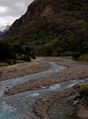
Valle Avilés, 7th january 2013. Pic: Colin Arisman
